

Part 3 of 5 in our August series on Public Safety and Hazard Mitigation in the Comprehensive Plan.
When most people hear “hazard mitigation,” they think of floods, tornadoes, wildfires, or winter storms. Those are real and familiar risks, especially in rural communities.
But communities also face hazards created by the systems we build, the materials we move, the infrastructure we depend on, and, occasionally, the harmful actions of people. A chemical spill on a highway, a rail derailment, a prolonged power outage, a water-system failure, an industrial fire, or a cyber disruption can upend daily life just as quickly as a storm.
The good news is that these risks are not beyond local control. Communities cannot eliminate every accident, equipment failure, or bad actor, but they can make smarter choices about where growth occurs, how critical facilities are protected, where roads and utilities need backup capacity, and how land uses fit together. That is where the comprehensive plan becomes more than a document about future development. It becomes a practical guide for keeping people safe, protecting local investment, and helping a community stay on its feet when something goes wrong.
Technological and man-made hazards are different from natural hazards in one important way: we put them there. And if we put them there, we also make the decisions about what goes next to them — through zoning, subdivision approval, and the future land use map that guides development for decades. The comprehensive plan is the document where those decisions are made. The question is whether it’s making them consciously.

The Hazards We Create — and the Ones We Ignore
Last week we discussed natural hazards, and how FEMA and the Department of Homeland Security categorize human-made hazards into two primary sub-groups of technological hazards and human-caused incidents.
Technological Hazards — unintentional events caused by industrial processes, failure of systems/structures, or everyday technology:
- Hazardous material spills or toxic releases.
- Major transportation accidents (air, rail, marine, highway).
- Critical infrastructure or computer system failures (e.g., power grid or 911 outages).
- Nuclear power accidents or industrial fires.
Human-Caused / Adversarial Incidents — intentional destructive acts carried out by individuals or groups:
- Terrorist attacks (conventional, cyber, or agro-terrorism).
- Use of chemical, biological, radiological, or nuclear (CBRN) weapons.
- Civil unrest, riots, or intentional sabotage.
| Category | Defining feature | Typical examples | Primary planning emphasis |
|---|---|---|---|
| Technological hazard | Unintentional failure, accident, malfunction, or release involving technology, infrastructure, materials, or industrial activity | HazMat spill, train derailment, dam/bridge failure, power outage, industrial explosion, 911 outage | Prevention, engineering controls, maintenance, redundancy, response capability, continuity |
| Human-caused / adversarial incident | Deliberate act intended to harm, disrupt, intimidate, coerce, or exploit a vulnerability | Terrorism, sabotage, cyberattack, active violence, civil disturbance, CBRN attack | Intelligence and threat assessment, security, deterrence, access control, coordinated law enforcement and emergency response |

Tech Hazards
Rural counties are full of man-made hazard sources that most comprehensive plans treat as background features of the landscape rather than planning considerations. Technological hazards are often “routine” emergency-management risks that can become community-scale disasters when they involve hazardous materials, key facilities, or interdependent infrastructure.
Technological hazards should be treated as place-based development and infrastructure risks, not solely emergency response issues. The local hazard mitigation plan (which we discuss throughout this series) supplies the risk assessment, mapped exposure, and mitigation actions; the comprehensive plan translates those findings into future land use, facility siting, capital improvement, infrastructure, and development-regulation policy. FEMA’s mitigation framework centers on identifying hazards, assessing vulnerability, and developing strategies to reduce future losses, while APA and FEMA specifically encourage integrating mitigation into comprehensive plans, zoning, and subdivision regulations,
Hazardous material incidents
Hazardous material incidents include unplanned releases of toxic, flammable, explosive, corrosive, radioactive, or otherwise dangerous substances. They can occur at fixed facilities — such as manufacturing plants, fuel terminals, water-treatment facilities, warehouses, laboratories, agricultural operations, and utility sites — or while materials are transported by truck, rail, pipeline, air, or water.
Illustrative incidents demonstrate the wide range of potential consequences. A 2005 rail collision in Graniteville, South Carolina, released chlorine gas, caused nine deaths, sent hundreds of people to hospitals with respiratory complaints, and required the evacuation of approximately 5,400 residents. In Lac-Mégantic, Quebec, a 2013 crude-oil train derailment released roughly six million liters of petroleum, killed 47 people, displaced approximately 2,000 residents, devastated much of the downtown, and contaminated nearby water resources. Fixed-facility incidents can be equally consequential: the 1976 Seveso, Italy, chemical-plant accident released toxic dioxin over surrounding communities and helped spur Europe’s major-accident-hazard regulations.
Common scenarios include chemical releases from storage tanks or process equipment; anhydrous-ammonia leaks at agricultural facilities; pesticide or fertilizer spills; petroleum-pipeline ruptures; tanker-truck crashes; rail derailments; and fires that generate toxic smoke, contaminated firefighting runoff, or long-term soil and groundwater contamination. The immediate protective action may be evacuation or shelter-in-place, but the land use implications can last for years where contamination constrains redevelopment or affects drinking-water supplies.
In 2005, a major fuel-storage incident at the Buncefield Oil Depot in Hertfordshire caused a large explosion and fire — one of the largest industrial incidents in Europe and the UK’s largest peacetime explosion. Subsequent investigations identified failures in tank-level monitoring, overfill prevention, and safety-management systems. It is useful when discussing fixed-facility risks, industrial buffers, emergency access, smoke-plume planning, and the importance of preventing fuel releases from entering water or drainage systems.
For land-use planning, the central issue is compatibility: avoiding the placement of homes, schools, day cares, hospitals, congregate-care facilities, and other difficult-to-evacuate uses in areas of high consequence near major chemical facilities or transportation corridors. The plan should also consider whether proposed industrial, logistics, or energy development will introduce new hazardous-material storage, transfer, or transport activity near existing neighborhoods.
Useful comprehensive-plan actions include:
- Map fixed-facility hazardous-material sites, hazardous-material transportation routes, pipelines, rail corridors, and environmentally sensitive receptors such as wells, streams, wetlands, and source-water protection areas.
- Establish land-use compatibility policies and, where justified, separation or buffering standards between high-risk facilities and sensitive uses.
- Direct intensive or hazardous industrial uses toward suitable areas with adequate access, emergency-response capacity, utility infrastructure, drainage controls, and separation from residential neighborhoods.
- Coordinate development review with the fire marshal, emergency manager, Local Emergency Planning Committee (LEPC), public works, utility providers, and environmental agencies.
- Require site design that supports incident access, firefighting-water supply, containment of contaminated runoff, clear addressing, and safe truck circulation.
- Identify redevelopment contingencies for potentially contaminated or abandoned industrial sites. There is some good technical and financial assistance out there for brownfield redevelopment.
Kimball, Nebraska, offers a useful small-town example I’ve worked on illustrating why hazardous-material planning belongs in the comprehensive plan. Our hazard-mitigation assessment identifies hazardous waste transport by truck and rail, chemical transfer points, and a concentration of critical facilities near the railroad and Highway 71/Interstate-80. The issue is not whether rail or freight activity should disappear; it is whether future land-use decisions recognize where chemicals move, where water wells and emergency facilities are located, and which routes must remain usable during an incident.
The Emergency Planning and Community Right-to-Know Act (EPCRA, see below) requires emergency planning around extremely hazardous substances and calls for identification of regulated facilities and transportation routes, response resources and procedures, release notification, affected populations, and evacuation arrangements—information that can materially improve the comprehensive plan’s future-land-use analysis.
Transportation incidents
As illustrated above, accidents involving highway, rail, aviation, marine, transit, pipeline, or freight systems, become planning-level hazards when their scale creates mass casualties, hazardous-material releases, prolonged network closure, evacuation needs, major economic disruption, or damage to nearby homes and critical facilities.
In 2023, a Norfolk Southern derailment in East Palestine, Ohio, involved dozens of rail cars carrying hazardous materials; a number of chemicals spilled and caught fire. The event triggered an evacuation order and a prolonged investigation, environmental monitoring program, cleanup, and public-health concern. It illustrates the common tie between hazard materials and transportation infrastructure, as well as how uncertainty about air, water, soil, and long-term health impacts can become a major component of community recovery even after immediate life-safety actions end.
The land use risk is especially pronounced where development abuts high-speed highways, at-grade rail crossings, rail yards, intermodal terminals, airports, ports, pipelines, or designated freight routes. A rail derailment, for example, may involve both immediate physical impact and a chemical-release plume that requires evacuation over a much wider area. A rural highway crash involving agricultural chemicals or fuel may close the community’s only reliable access route for hours or days. A bridge failure may isolate neighborhoods, emergency services, farms, or industrial employers.
Comprehensive planning should move beyond simply mapping roads and railways. It should assess exposure, access, and network redundancy:
- Identify high-risk freight corridors, rail crossings, pipeline crossings, airport influence areas, bridges, truck routes, and locations with recurring crash patterns.
- Avoid locating new schools, high-density residential development, emergency shelters, hospitals, and other high-occupancy or mobility-limited uses immediately adjacent to high-consequence transportation corridors when safer alternatives exist.
- Preserve emergency access, secondary routes, street connectivity, and evacuation capacity in new development.
- Protect rights-of-way and plan grade separations, crossing upgrades, access management, turn lanes, and truck-routing improvements where warranted.
- Coordinate industrial and logistics land use with road capacity, bridge load limits, rail access, parking, noise, air quality, and neighborhood protection.
- Include transportation detours and access continuity in capital improvement plans and programming, particularly for communities with few alternate routes.
Many times, simply assuring a second way out may be the best local planners can do. That as it is, transportation safety should be framed not only as a mobility issue but as a community-resilience issue: the failure or closure of one segment can disrupt emergency response, employment access, supply deliveries, and regional economic activity.
Infrastructure failure
Infrastructure failure encompasses the disruption, degradation, or collapse of systems necessary for daily life and emergency operations: electric power, drinking water, wastewater, stormwater, roads and bridges, communications, public safety dispatch, fuel distribution, and information technology. Failures may result from aging assets, inadequate maintenance, design defects, extreme demand, construction accidents, equipment breakdown, human error, or cascading damage from another event.
Infrastructure failures can range from the loss of a single facility or component to cascading, regional disruption. The 2003 Northeast blackout, caused by a combination of transmission-line failures, inadequate situational awareness, and a failed alarm system, left an estimated 50 million people in the United States and Canada without power. In 2007, I was living in Minnesota when the I-35W bridge collapse in Minneapolis killed 13 people and injured 145 after undersized structural gusset plates failed under increased bridge weight and construction loading. Communications failures can likewise become life-safety events: in 2014, a 911 routing failure in Colorado prevented more than 6,600 emergency calls from reaching the appropriate call center across seven states.
Extended power outages illustrate the cascading nature of this hazard. Electricity loss can disable water pumps and wastewater lift stations, interrupt fuel dispensing, impair telecommunications and internet access, spoil food and medicine, close businesses, reduce heating or cooling, and create life-safety risks for residents who depend on electrically powered medical equipment. A 911 outage can impede emergency dispatch even when first responders remain available. Water-system failure can affect hospitals, schools, fire suppression, food establishments, and industrial operations simultaneously.
In 2000, heavy rainfall in Ontario, Canada, contributed to contamination of a municipal well with E. coli O157:H7 and Campylobacter. Inadequate treatment, monitoring, and response allowed contaminated water to enter the system; seven people died and more than 2,300 became ill. While often discussed as a public health disaster, it is also an infrastructure-governance failure involving source-water protection, system operation, maintenance, monitoring, regulatory oversight, and public notification.
The comprehensive plan should identify infrastructure not merely as public works, but as critical lifelines supporting all other community functions. Appropriate policies include:
- Inventory critical facilities and lifeline assets, including substations, water treatment plants, lift stations, wells, reservoirs, emergency operations centers, dispatch centers, communications towers, bridges, and fuel distribution points.
- Identify single points of failure and facilities without backup power, alternate supply, spare equipment, redundant communications, or alternative access.
- Direct growth only where water, wastewater, drainage, power, road, and communications capacity can be extended and maintained reliably.
- Use the capital improvement program to prioritize replacement, hardening, redundancy, backup generation, interconnection, storage, and preventive maintenance.
- Require utility coordination during annexation, subdivision review, and major-site development review.
- Protect utility corridors, easements, tower sites, water sources, and critical facilities from incompatible development.
- Incorporate continuity-of-operations needs into public-facility siting and design, including backup power, fuel access, secure communications, and all-weather access.
The experience reflected in the Clay County, Nebraska, Comprehensive Plan shows how infrastructure failures cascade. Severe weather has damaged buildings and a grain elevator, knocked out power for days, and placed pressure on transportation and emergency services. The County has responded by providing backup generation at its newer office complex, sheriff’s office, jail, and public-safety answering point—small but important investments that help keep government and emergency operations functioning when normal systems fail.
Industrial and energy incidents
Accidents or failures at facilities that manufacture, store, process, generate, transmit, or distribute energy and industrial materials are far too common to ignore. Examples include manufacturing explosions; refinery and grain-elevator fires; mine incidents; fuel-storage and propane explosions; electric-substation failures; wind, solar, battery-storage, or transmission-system incidents; nuclear-power events; and accidents involving oil, gas, biofuel, fertilizer, or industrial-chemical operations.
Industrial and energy incidents can produce consequences far beyond the affected facility. In the city of West, Texas, population 2,500, a 2013 fire at a fertilizer storage and distribution facility triggered an ammonium-nitrate explosion that killed 15 people, injured hundreds, and damaged nearby homes, a school, and a nursing home. In San Bruno, California, a 2010 natural gas transmission-pipeline rupture released an estimated 47.6 million cubic feet of gas, ignited, killed eight people, destroyed 38 homes, and damaged 70 more. The 2017 Didion Milling explosions in Cambria, Wisconsin, which killed five workers, further demonstrate the combustible-dust risk associated with agricultural and food-processing operations.
These facilities may create risks that are highly localized but severe: blast zones, smoke plumes, toxic releases, fire spread, water contamination, electrical hazards, or extended service interruption. In rural and small-town settings, the issue may arise at grain-handling operations, ethanol plants, agricultural chemical dealers, pipelines, power substations, renewable-energy installations, or industrial parks located at the edge of town. A single facility can also be a major employer, which means an incident may produce both a public-safety emergency and a substantial economic-development setback.
The Upper Big Branch Mine disaster in West Virginia is illustrative. In 2010, an underground coal mine explosion killed 29 miners. While the immediate incident was primarily an occupational disaster, mine emergencies can have wider community impacts through road closures, emergency-resource demand, water-quality concerns, loss of a major employer, and long-term economic disruption.
The comprehensive plan should balance economic-development objectives with risk-informed site selection and design:
- Identify appropriate industrial and energy-development areas through suitability analysis that considers topography, drainage, prevailing conditions, emergency access, utility capacity, proximity to sensitive land uses, and environmental resources.
- Establish compatibility policies for high-hazard industrial uses, including buffers, transitional land uses, landscaping, setbacks, and limits on sensitive receptors nearby.
- Ensure industrial areas have adequate water supply, hydrant capacity, emergency vehicle access, road geometry, rail or truck circulation, and stormwater systems designed to contain contaminated runoff where appropriate.
- Protect emergency access routes from congestion, encroachment, and development patterns that create dead ends or constrain heavy-response equipment.
- Require early consultation among applicants, fire and emergency services, utilities, public works, and planning staff for high-consequence projects.
- Coordinate with employers on business continuity, employee notification, evacuation, sheltering, mutual aid, and post-incident economic recovery.
Our Grand Island, Nebraska, Comprehensive Development Plan shows what a more developed local capability looks like. The community tracks fixed-site and transportation-related hazardous-material events, recognizes the exposure created by multiple rail lines and major highways, and works through the Hall County LEPC on chemical identification, training, and exercises. The lesson is not that every rural county needs a large-city response apparatus; it is that planning, fire, emergency management, health care, and industry should be working from the same map and the same set of assumptions.
Technology-dependent service disruption
Technology dependent service disruption refers to an accidental failure in the digital systems that support public services, utilities, commerce, communications, health care, transportation, and government administration. The initiating event is not malicious: it may be a flawed software update, configuration error, cloud-service outage, vendor failure, equipment malfunction, data-center disruption, damaged fiber line, overloaded network, or human error during system maintenance.
Technology-dependent disruptions can arise from routine maintenance, faulty software, vendor outages, accidental damage, or equipment failure rather than criminal activity. In July 2024, a defective CrowdStrike content update caused widespread Windows-system crashes and disrupted airlines, hospitals, banks, broadcasters, retailers, and government services worldwide; CrowdStrike confirmed that the event was not a cyberattack. In New Zealand in 2025, an accidental contractor cut and rodent damage severed the two principal fiber routes serving Otago and Southland, disrupting mobile, internet, and telephone service and requiring Fire and Emergency New Zealand to rely on backup communications systems.
Despite a non-malicious origin, the impact can be extensive. A vendor outage could disrupt utility billing, permitting, payroll, digital records, public alerts, dispatch systems, online payment platforms, or school operations. A telecommunications failure can impair 911 calling, public notifications, payment processing, remote work, and coordination among field crews. A data center failure may incapacitate multiple public and private entities at once if they rely on the same hosted platform.
This hazard is increasingly relevant to land use planning because physical development and public service delivery depend on digital infrastructure. New development may increase demand for broadband, cellular coverage, smart-meter systems, traffic-control networks, digital permitting, remote health care, and cloud-managed utility infrastructure. The plan should therefore treat communications and information systems as part of the community’s critical infrastructure.
Recommended policies and actions include:
- Incorporate technology disruptions into exercises and HMP mitigation actions, not solely into information-technology plans.
- Identify critical digital dependencies for local government, utilities, public safety, hospitals, schools, transportation providers, and major employers.
- Require or encourage redundant communications pathways, backup power for communications sites, geographically diverse data backups, and alternate work locations for essential functions.
- Include telecommunications facilities such as broadband, cellular coverage, fiber routes, dispatch communications, and public-alerting capability in infrastructure inventories and capital improvement planning.
- Avoid unnecessary concentration of critical systems in one building, one vendor, one network path, or one geographic location.
- Require continuity plans that provide manual workarounds for essential services such as dispatch, water operations, payroll, permitting, and public communications.
Technological hazards may not command the same attention as a flood, tornado, or wildfire, but they can disrupt a community just as thoroughly—and often with far less warning. A chemical release, train derailment, prolonged utility outage, industrial fire, bridge collapse, or technology failure can quickly become a public-health emergency, an economic-development problem, and a test of local government’s ability to keep essential services running. That is why the comprehensive plan should not leave these risks solely to emergency managers.
The comp plan can help communities make smarter everyday choices about where homes, schools, industry, utilities, roads, and critical facilities are located; where growth should occur; which infrastructure needs backup capacity; and where a little more distance, access, redundancy, or design attention can prevent a bad day from becoming a long-term disaster. Zoning, subdivision regulations, site-plan review, capital improvement programming, and close coordination with the local hazard mitigation plan are not glamorous tools, but they are practical ways to reduce exposure, protect vulnerable residents, and keep a community functioning when something important fails.

Human-Caused Hazards
Adversarial hazards require the same life-safety and continuity capabilities as technological events, but add a security dimension: an actor may deliberately choose vulnerable targets, exploit response gaps, create cascading effects, or use misinformation to magnify disruption. Intentional and adversarial hazards should be incorporated into comprehensive planning as security, continuity, and land-use compatibility concerns—not only as law-enforcement or emergency-response responsibilities. The local hazard mitigation plan can identify exposed assets, vulnerable populations, and priority actions; the comprehensive plan can shape development patterns, facility design, infrastructure redundancy, capital investment, and interagency coordination to reduce consequences before an incident occurs.
Terrorism and targeted violence or sabotage
Terrorism and sabotage involve deliberate acts intended to injure people, disrupt public life, damage property, intimidate a population, or impair essential services. Terrorist attacks may use explosives, firearms, vehicles, incendiaries, drones, or other means against people, facilities, gatherings, or symbolic targets. Targeted violence may occur at schools, workplaces, houses of worship, entertainment venues, government facilities, health-care sites, or public events. Sabotage includes deliberate damage to utilities, transportation assets, industrial systems, public buildings, communications equipment, or supply chains.
Past terrorist incidents have repeatedly shown that mitigation is not limited to law enforcement or intelligence. The 2017 Manchester Arena bombing in England was followed by a public inquiry that recommended terrorism risk assessments, security-perimeter planning, staff training, CCTV and patrols, and early consideration of security when public venues are built or converted to new uses. Vehicle attacks on Westminster and London bridges led to temporary and permanent hostile-vehicle measures designed to protect pedestrians while preserving walking, cycling, emergency access, and the quality of public space. The broader lesson for comprehensive planning is straightforward: local governments cannot predict every threat, but they can use site design, public-facility planning, transportation design, infrastructure redundancy, and development review to reduce foreseeable vulnerabilities and limit the consequences of an attack.
Intentional hazards can take many forms, from targeted violence at a school, workplace, public event, or civic facility to sabotage of a utility, bridge, fuel terminal, rail corridor, or communications asset. The most relevant concern for comprehensive planning is not predicting a specific attacker, but reducing foreseeable vulnerabilities in the built environment. Street and site design can limit uncontrolled vehicle access to crowded public areas; facility siting and design can preserve emergency access, visibility, safe egress, and appropriate stand-off distance; and infrastructure planning can reduce the consequences of sabotage by avoiding single points of failure in power, water, transportation, fuel, and communications systems. The US Department of Homeland Security (DHS) provides guidance specifically recognizing public gatherings as vulnerable to active-shooter, bombing, drone, and vehicle-ramming attacks, and provides tools for assessing risks in city streets and special-event areas.
The 9/11 attacks in the US produced broad reviews of aviation security, intelligence sharing, building evacuation, emergency communications, and continuity of government. That may seem well above local comprehensive planning, but there are lessons from the 9/11 Commission to apply at home:
- Large, high-occupancy buildings need workable evacuation plans, emergency communications, and continuity-of-operations arrangements.
- Critical public functions should not be unnecessarily concentrated in a single building or corridor without alternate capability.
- Emergency operations centers, interoperable communications, and unified command arrangements need to be planned before an incident, not improvised afterward.
- Public-facility design should account for emergency access, staging, evacuation, and recovery operations. A 9/11 Commission hearing cited full-building evacuation planning, adequate communications, and continuity of operations as core preparedness elements.
From a comprehensive-planning perspective, again, the issue is not to predict a specific attacker or event. We can’t do that. The iea is to reduce avoidable exposure, eliminate design vulnerabilities where practical, protect critical assets, and ensure that the community can continue functioning after a disruptive incident. High-occupancy civic destinations, public-event areas, government complexes, critical utility sites, transportation hubs, emergency facilities, and facilities with symbolic or economic importance deserve particular attention.
Planning considerations include:
- Identify critical facilities, high-occupancy sites, public gathering areas, utility assets, transportation nodes, and economic anchors that could create severe community consequences if disrupted.
- Avoid unnecessary concentration of critical functions in a single facility, district, or access corridor; pursue geographic dispersion and operational redundancy where feasible.
- Design public spaces, civic facilities, streetscapes, parking areas, and entrances to support appropriate surveillance, clear sight lines, managed access, emergency vehicle movement, and orderly evacuation without making public places inaccessible or hostile.
- Incorporate secure but welcoming site-design practices into public-facility planning, redevelopment, special-event planning, and development review.
- Protect public utility, communications, transportation, and emergency-service assets through setbacks, controlled access, secure equipment locations, backup systems, and alternative routes.
- Coordinate land use decisions with emergency management, law enforcement, fire and EMS, public works, schools, hospitals, utilities, and major employers.
- Ensure that continuity-of-operations planning is part of the design and siting of essential public facilities.
Planning should recognize that a targeted incident can create secondary hazards: fire, structural damage, mass-casualty needs, contamination, transportation disruption, service outages, displacement, and long-term economic harm. This reinforces the need for unified command, interoperable communications, and pre-established roles among public-safety agencies.
Cyberattack
Deliberate attempts to compromise, disrupt, manipulate, destroy, or gain unauthorized access to computer systems, data, networks, or operational technology are in the headlines too often these days. Common examples include ransomware; destructive malware; theft or release of sensitive data; denial-of-service attacks on public websites; compromise of vendor systems; and attacks on industrial-control systems used in water, wastewater, electricity, traffic management, building controls, and manufacturing.
Recent cyberattacks have targeted the computer systems that help run U.S. water and wastewater plants. Federal agencies warn that Iranian-linked actors have focused on internet-connected control devices used to operate pumps, valves, and treatment equipment. These attacks can confuse operators, disrupt normal service, or force a utility to run equipment by hand, even if they do not immediately contaminate the water. Water systems can lower the risk by keeping control equipment off the open internet, using strong passwords and multi-step logins, separating control systems from office networks, keeping backup copies of system settings, and practicing manual operations.
The land use connection is indirect but increasingly important. Communities rely on digital systems to operate their physical systems: water treatment, wastewater lift stations, traffic signals, emergency dispatch, utility billing, electronic permitting, public alerts, hospitals, payroll, schools, and public records. A cyberattack can therefore become a land-use and infrastructure disruption when it disables the systems needed to operate a growing community safely.
Water and wastewater systems are illustrative: their vulnerability may include physical attacks, cyberattacks, and deliberate contamination. A compromise of operational technology can affect treatment processes, pump operations, chemical dosing, storage levels, water pressure, or wastewater collection. For local planning, the lesson is that safe water service now depends on both physical infrastructure—pipes, tanks, pumps, and plants—and reliable digital controls.
Comprehensive plan actions could include:
- Treat communications, information technology, operational technology, broadband, and emergency-alerting systems as components of critical infrastructure.
- Inventory essential digital dependencies of local government, public safety, utilities, health care, schools, transportation providers, and major employers.
- Identify where reliance on a single vendor, cloud platform, data center, communications path, software system, or network creates a single point of failure.
- Direct capital investment toward redundant communications, backup power for network and dispatch facilities, secure data storage, alternate communications pathways, and manual operating capability for essential services.
- Require continuity arrangements for critical services, including protected backups, alternate work sites, paper-based or offline procedures, and tested communications plans.
- Integrate cybersecurity expertise into utility planning, capital-improvement programming, public-facility modernization, and development review for critical facilities.
- Coordinate with state and federal cybersecurity resources and ensure timely reporting procedures for suspected compromises.
The US DHS’ Critical Infrastructure Security and Resilience Agency (CISA) advises organizations to maintain a current inventory of information-technology assets and apply hardening guidance to strengthen configurations—basic actions that also help a local government understand and protect its digital service dependencies.
CBRN incidents
The deliberate use, attempted use, or credible threat involving chemical, biological, radiological, or nuclear agents is termed a “CBRN” incident. The related term CBRNE adds explosives. Unlike an accidental hazardous material event, a CBRN incident involves intent to harm, intimidate, coerce, or disrupt. DHS research explicitly addresses threats involving either accidental or intentional large-scale chemical, biological, radiological, and nuclear incidents; for planning purposes, the distinguishing issue is the deliberate nature of the act and the related security, investigative, and evidence-preservation requirements.
Potential scenarios include the release of a toxic industrial chemical, deliberate contamination of a building or water system, dissemination of a biological agent, placement of a radiological source, or an explosive incident that spreads chemical or radiological material. Deliberate CBRN incidents are rare, but even smaller communities may still face credible CBRNE threats involving improvised explosives, suspicious materials, threats to rural gathering places, or disruption of utility systems that manage hazardous treatment chemicals. Recent responses in places such as Bucks County, Pennsylvania; Green Township, Ohio; Harrison Bay State Park, Tennessee; and rural Suffolk, England, demonstrate that a serious incident may require evacuation, exclusion zones, mutual aid, specialized technical support, public communication, evidence preservation, and continuity of essential services even outside a major metropolitan area.
Comprehensive planning does not replace law-enforcement intelligence, health surveillance, or specialized hazardous-material response. It can, however, reduce physical vulnerability and improve consequences management:
- Identify facilities and systems where contamination would have particularly serious impacts: drinking-water sources, water-treatment and wastewater facilities, food-processing sites, hospitals, laboratories, schools, high-occupancy buildings, and emergency facilities.
- Protect water sources, treatment sites, chemical storage areas, air-intake locations, and sensitive utility components through controlled access, secure siting, monitoring, and appropriate buffers.
- Avoid placing sensitive uses or dense, difficult-to-evacuate development in high-consequence locations near major chemical storage, transport, or industrial facilities when alternatives exist.
- Incorporate shelter-in-place capability, emergency access, building ventilation considerations, communication redundancy, and decontamination-site planning into critical-facility planning.
- Coordinate planning with fire and HazMat teams, emergency management, public health, law enforcement, utilities, hospitals, schools, and the LEPC.
- Plan for longer-term consequences, including contamination assessment, waste disposal, environmental cleanup, business interruption, population displacement, public information, and economic recovery.
Civil disturbance
Civil disturbance includes riots, politically motivated violence, sustained disorder, or other public disturbances that threaten people or property and disrupt essential functions. Federal law defines civil disorder as a public disturbance involving violent acts by three or more people that creates an immediate danger of, or results in, injury or property damage.
These incidents can disrupt transportation, business activity, emergency response, public services, and the use of downtowns, civic districts, campuses, and public spaces. After-action reviews consistently point to the importance of interagency communication, mutual aid, public notification, emergency access, crowd movement, and coordinated street and transit management. Following civil unrest in California in 2020, the state’s after-action report identified communications gaps, mutual-aid coordination problems, training and equipment needs, and the need for better surge planning. A 2022 United Kingdom review of public disorder similarly recommended that local authorities consider crowd flow, road closures, signage, and the management of town-center public space near licensed premises.
A comprehensive plan should not frame protest or public expression itself as a hazard. Peaceful assembly is a normal civic activity. The planning concern is the relatively uncommon situation in which violence, arson, vandalism, blocked access, or prolonged disorder creates public safety risks and disrupts transportation, commerce, government operations, emergency response, or the use of public space.
Land use and urban design choices can either reduce or compound these impacts. Downtowns and civic districts benefit from public spaces that can accommodate lawful gatherings while maintaining emergency access, clear pedestrian routes, sanitation, transit operations, and access to businesses and residences. Communities also need plans that avoid disproportionately concentrating disruptive impacts on vulnerable neighborhoods or small businesses.
Appropriate actions include:
- Identify civic districts, downtowns, campuses, public squares, government buildings, transit nodes, and event areas where large gatherings are likely.
- Design and manage public spaces to support lawful assembly, clear circulation, access for emergency responders, accessible exits, adequate lighting, and effective public communication.
- Maintain transportation and emergency access plans for street closures, detours, transit interruptions, and alternate access to hospitals, fire stations, businesses, and residences.
- Coordinate protocols among law enforcement, fire/EMS, emergency management, public works, transit providers, downtown organizations, and event operators.
- Protect water, power, communications, and public-safety infrastructure located within gathering areas or vulnerable commercial districts.
- Establish business-continuity and rapid-recovery support for affected small businesses, cultural institutions, and community organizations.
- Include responder safety, mutual aid, interoperable communications, and public-information coordination in training and exercises.
FEMA-linked research notes that civil unrest can strain local resources, cause property damage, and lead to responder injuries or deaths; it emphasizes identifying gaps through planning and exercises, and ensuring partnerships, tools, and resources are in place for response and recovery.
Agroterrorism
The intentional introduction or threatened introduction of animal disease, crop disease, pests, invasive organisms, or food system contamination to cause economic harm, public fear, supply disruption, or social instability is termed “Agroterrorism”. It is especially relevant to rural and agricultural communities because agriculture, food processing, livestock production, agricultural transport, and water resources may be central to the local economy.
Confirmed agroterrorism cases are rare. The clearest U.S. example is the 1984 salmonella attack in The Dalles, Oregon, when a religious cult intentionally contaminated restaurant salad bars with Salmonella in an effort to influence a local election. More than 750 people became ill. Many major animal disease outbreaks are not agroterrorism, even when the consequences resemble one. They may result from natural spread, accidental introduction, illegal animal movement, or biosecurity failures.
Planning for an agroterrorism event considers incidents such as a livestock disease outbreak, deliberate contamination of feed or food products, intentional spread of crop pathogens, release of destructive pests, or interference with slaughter, storage, processing, or distribution systems. Even a limited event caould lead to quarantines, animal depopulation, loss of market access, business interruption, labor impacts, food-price increases, reputational damage, and long-term effects on producers and agricultural communities.
Comprehensive planning can contribute by recognizing the agricultural and food system as critical economic infrastructure, rather than treating it only as a land-use category. This is particularly important in communities with livestock concentrations, feedlots, grain handling, food-processing plants, ethanol facilities, agricultural chemical suppliers, farm-to-market logistics, or major agricultural research and extension functions.
Key planning actions include:
- Plan for indirect consequences: worker displacement, disrupted freight, reduced tax base, loss of export markets, stress on local businesses, and reputational impacts on the community and region.
- Map and protect agricultural production areas, livestock facilities, processing plants, feed and seed suppliers, grain-storage and handling facilities, cold storage, food-distribution sites, agricultural transport corridors, and water resources.
- Avoid land-use conflicts that impede necessary agricultural biosecurity measures, emergency vehicle access, quarantine operations, disposal, or logistics.
- Coordinate with producers, extension services, veterinarians, animal-health officials, public health agencies, food processors, emergency management, and economic-development organizations.
- Identify potential sites and procedures for animal quarantine, temporary staging, disposal, decontamination, mass feeding, worker support, and continuity of agricultural commerce (also necessary for natural disaster mitigation).
- Protect agricultural water supplies, drainage systems, and food-processing infrastructure from contamination and access vulnerabilities.
- Include agricultural businesses in continuity planning, emergency communications, mutual aid, and post-incident economic-recovery strategy.
Not every human-caused incident is terrorism. A malicious insider, vandal, disgruntled employee, criminal extortionist, or ideologically motivated offender can create a major emergency without fitting a narrow terrorism definition.
Natural hazards happen to communities. Man-made hazards are approved by them — one permit at a time.
What EPCRA Tells You — and How to Use It
The Emergency Planning and Community Right-to-Know Act (EPCRA) requires facilities that store or use hazardous chemicals above threshold quantities to report annually to their State Emergency Response Commission and Local Emergency Planning Committee (LEPC). The result is a publicly available database of hazardous material sites — Tier II reports — that identifies every regulated facility in a county, the chemicals stored there, and the quantities on hand.
This is exactly the kind of information a comprehensive plan’s hazard chapter should include. Most plans never reference it — not because the information is unavailable, but because the connection between LEPC data and land use planning has never been made explicit.
For planners, EPCRA Tier II data provides a starting point for several important planning tasks: mapping the location of hazardous material sites relative to schools, hospitals, residential areas, and other sensitive land uses; identifying facilities that may warrant buffer zone requirements or conditional use restrictions; and understanding which transportation corridors carry the greatest hazardous material risk.
Consider a county that overlays its EPCRA Tier II facilities, its Pipeline and Hazardous Materials Safety Administration (PHMSA) pipeline data, and its railroad corridors on a single GIS map — and then compares that map to its future land use designations. That exercise will almost always reveal conflicts: proposed residential development near a pipeline corridor, a school sited within the potential impact zone of a chemical facility, a new commercial district adjacent to a rail line carrying hazardous goods.
Those conflicts are not inevitable. They are the product of planning decisions made without reference to available hazard data. And they can be addressed — through buffer requirements, overlay districts, conditional use standards, and siting criteria — before development makes them permanent.
📋 Planning Takeaway Your county’s EM should receive Tier II hazardous material reports every year. Your comprehensive plan almost certainly doesn’t reference them, even accounting for required trade secrets and non-disclosure restrictions. Connecting those sources — adding a hazardous materials facility map to your plan’s public safety chapter and establishing buffer standards in your zoning regs — is one of the highest-impact, lowest-cost improvements a county can make to its hazard planning framework.

Compatibility Planning: Keeping Incompatible Uses Apart
The planning tool most directly applicable to man-made hazards is compatibility planning — the deliberate use of zoning, buffer requirements, and land use designations to keep incompatible uses separated from each other.
Compatibility planning is not new. Agricultural protection zoning has long used minimum lot sizes and buffer requirements to separate farming operations from residential development. Industrial zoning establishes districts where heavy uses can locate away from residential areas. What most counties lack is a systematic approach to compatibility planning that accounts for hazard risk — not just nuisance impacts like noise and odor, but genuine safety risks from fire, explosion, chemical release, and transportation accidents.
A Framework for Planning
A compatibility planning framework for man-made hazards might include:
Pipeline setback requirements
Many states have no mandatory setback requirements for development near pipelines. Counties can in certain circumstances adopt their own standards — minimum setbacks from high-pressure natural gas lines, hazardous liquid pipelines, and gathering lines — as part of their development regulations. PHMSA provides consequence modeling data that can inform appropriate setback distances.
Railroad buffer zones
For rail lines, especially those carrying significant quantities of hazardous materials, a zoning overlay that restricts high-density residential development, schools, hospitals, and other sensitive uses within a defined buffer can reduce the consequences of a derailment or release. This doesn’t prevent railroad operations — there is no way for a local jurisdiction to do that — it simply manages what goes next to them.
Hazardous material facility overlay districts
An overlay district that applies additional review requirements to development within a defined radius of EPCRA-regulated facilities gives planning staff and elected officials a systematic basis for evaluating the hazard implications of new development proposals. It doesn’t prohibit development — it requires that hazard implications be considered before approval is granted.
CAFO siting standards
Minimum setbacks from residential areas, schools, and water bodies; required manure management plans; and mandatory odor impact assessments can all be incorporated into conditional use permit standards for large animal feeding operations. These standards protect neighboring landowners while giving producers a clear framework for siting decisions.
Jefferson County, Nebraska, or example, identified the sort of information many rural comprehensive plans overlook: crude oil and benzene moving by rail, a 40-inch natural-gas pipeline crossing the county and nearby communities, and the practical need to notify residents and practice shelter-in-place procedures. That is the beginning of compatibility planning—not a ban on infrastructure, but a recognition that future growth, emergency access, and public communication must account for what already runs through the landscape.
The best examples of mitigation of man-made hazards are not in communities who claim to have eliminated risk; they are communities who have identified where risk sits and begun to connect it to daily planning decisions.
The Evacuation Planning Gap
One dimension of man-made hazard planning that is almost always missing from comprehensive plans is evacuation planning. Natural gas pipeline ruptures, train derailments carrying hazardous materials, and industrial facility releases can all require rapid evacuation of the surrounding area — sometimes within minutes.
Evacuation planning is primarily the responsibility of emergency management, but the comprehensive plan shapes the physical conditions that determine whether evacuation is possible. Road networks with single points of access, dead-end subdivisions, and bridges with weight limits that restrict emergency vehicle movement are all land use outcomes that affect evacuation capacity. A comprehensive plan that requires multiple access points for new subdivisions, maintains emergency egress corridors near high-hazard facilities, and coordinates road network planning with evacuation route needs is doing hazard mitigation work — even if it doesn’t call it that.
As we discussed in Week 1 on public safety and land use and Week 2 on natural hazards, the comprehensive plan accumulates individual land use decisions into patterns that are very difficult to reverse. A subdivision approved with a single access road next to a pipeline corridor is a decision that may matter enormously on the day a rupture requires evacuation — and that decision was made years earlier, by a planning commission that never made the connection.
What a GIS Overlay Reveals
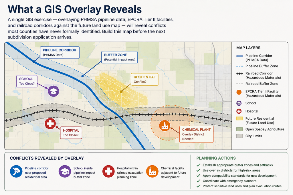
A single GIS exercise — overlaying PHMSA pipeline data, EPCRA Tier II facilities, and railroad corridors against the future land use map — will reveal conflicts most counties have never formally identified. Build this map before the next subdivision application arrives.
Building a Risk-Informed Comprehensive Plan: Where We Are
Week 1 — Public Safety Infrastructure
Week 2 — Natural Hazards
Week 3 — Technological & Human-Caused Hazards  ← you are here
Week 4 — Flooding & Floodplain Management
Week 5 — The Hazard Mitigation Plan
         ↓
One Risk-Informed Comprehensive Plan
Planning for What We Can Influence
Human-made hazards can feel complicated because they cross so many lines: land use, transportation, utilities, public safety, economic development, agriculture, health care, and technology.
Yet the basic planning response is familiar. Know where the risks are. Keep incompatible uses apart. Preserve more than one way in and out. Protect water, power, communications, and emergency services. Build in backup capacity where it matters most. Talk to the people who operate the systems every day — farmers, utilities, emergency responders, school leaders, business owners, hospitals, and industry—and make sure the comprehensive plan reflects what they know.
The local hazard mitigation plan provides the risk assessment and project list; the comprehensive plan gives those findings a home in everyday decisions about zoning, subdivision design, capital improvements, infrastructure, and public facilities. No plan can promise that nothing will fail. A good plan can make failure less likely, less damaging, and easier to recover from. That is not alarmism. It is simply good stewardship of the places we call home.
Next Sunday, August 23rd, we turn to the hazard that is both natural and man-made, both predictable and preventable: floods and floodplain management.
Questions about man-made hazards and compatibility planning in your comprehensive plan? I am looking for my next big thing —maybe I can help?
I am getting ready for my presentation on Heritage Tourism in Planning coming up at the Western Planner Conference coming up in Sioux Falls 26-28 August. Always a great time.

FURTHER READING
The hazardous materials data referenced in this article is publicly available and already covers your county. The resources below will help you go deeper — whether you’re looking for pipeline data, EPCRA reporting guidance, or compatibility planning frameworks for local governments.
Tools & Data
- EPA Emergency Planning and Community Right-to-Know Act — US EPA website for EPCRA program, with links for more information (US federal website are changing rapidly these days).
- EPA Toxic Release Inventory (TRI) — Annual data on toxic chemical releases and waste management from industrial facilities. Useful for identifying facilities with significant chemical hazard profiles.
- PHMSA National Pipeline Mapping System — US DOT interactive map of all regulated pipelines in the United States by location, operator, and product type. The essential starting point for pipeline hazard analysis in any comprehensive plan. Limited public access.
Reports & Research
- EPCRA and Local Emergency Planning: A Guide for Communities — EPA guidance on the LEPC process, Tier II data access, and the connection between emergency planning and land use.
- Hazardous Materials Transportation Risks — Transportation Research Board analysis of hazardous materials transportation risks.
- Preventing the spark: How can rural areas respond to the UK’s rising wildfire risk? — English researcher Jessica Sellick, PhD, briefing on wildfires in the context of Great Britain, what rising wildfire activity means for rural communities, and current efforts to close the gaps.
Planning Guidance
- FEMA Integrating Hazardous Materials into the Local Comprehensive Plan — FEMA guidance on addressing man-made and technological hazards in a local comprehensive planning process.
- OECD Guiding Principles for Chemical Accident Prevention, Preparedness and Response ‑ Third Edition — Chapter 14 Land-use Planning provides genral principles for prevention and mitigation of chemical accidents.
- Hazardous Materials Planning Guide — LEPC Handbook. A practical reference for local emergency planning committees and planners working at the intersection of hazardous materials management and land use planning.
Books
- Encyclopedia of Technological Hazards and Disasters in the Social Sciences — Duane A. Gill, Liesel A. Ritchie, and Nnenia M. Campbell, ed. (Edward Elgar Publishing, 2024)
A massive, multi-contributor reference exploring the social, political, and cultural origins and aftermaths of human-caused disasters. An expensive book new, so be sure to check interlibrary loan! - The Devil Never Sleeps: Learning to Live in an Age of Disasters — Juliette Kayyem (Public Affairs, 2022)
A former deputy secretary of Homeland Security discusses disaster response, recovery, and resilience. - A Century of Man-Made Disasters — Nigel Blundell (Pen and Sword History, 2019)
A catalog of 20th-century mechanical, structural, and industrial misadventures born of industrial scale and human folly. - The Only Plane in the Sky: An Oral History of 9/11 — Garrett M. Graff (Avid Reader Press / Simon & Schuster, 2019)
Weaves together hundreds of first-person accounts from victims, first responders, political leaders, and families. - Inviting Disaster: Lessons From the Edge of Technology: An Inside Look at Catastrophes and Why They Happen — James R. Chiles (Harper Business, 2001)
Explores major technological accidents—from structural collapses to power grid failures—and the recurring patterns of human error behind them. - The Lac-Mégantic Rail Disaster: Public Betrayal, Justice Denied — Bruce Campbell (Lorimer, 2018)
An in-depth analysis of the deadly 2013 runaway oil train derailment and explosion in Quebec, exploring regulatory failures and the transport of volatile crude oil. - Toxic Communities: Environmental Racism, Industrial Pollution, and Residential Mobility — Dorceta Taylor (NYU Press, 2014)
Explores how low-income and minority neighborhoods face disproportionate placement of hazardous waste and industrial facilities due to zoning and segregation. - The Buncefield Explosion — David Fieldstein, ed. (Sceptre Education, 2006)
A documentary record featuring photographs of the massive blaze, local maps, site diagrams, and accounts of the emergency response and local impact. - Land Use and Society: Geography, Law, and Public Policy — Rutherford Platt. (Island Press, 1995)
A broad examination of how land use decisions shape community outcomes, including exposure to industrial and technological hazards. - Planning for Disaster: How Natural and Manmade Disasters Shape the Built Environment — William G. Ramroth, Jr. (Kaplan Publishing, 2007) — Our August 2026 book of the month.
Architect Bill Ramroth outlines how disasters have shaped history and how we can make incremental improvements to do better the next time disaster lands.
This page contains affiliate links. As an Amazon Associate, JCShepard.com earns from qualifying purchases at no additional cost to you.
Webinar Alert!
The Maryland Department of Planning is hosting an online webinar on Tuesday 25 August 2026, “The Venn Diagram Between Hazard Mitigation Plans and Comprehensive Plans”.
“In partnership with the Mid-Atlantic Planning Collaboration, the Maryland Department of Planning (MDP) is presenting this webinar to explore trends in the hazard mitigation planning field, share insights and recommendations from the newly adopted Maryland Hazard Mitigation Plan, elaborate strategies for resilience planning with an equity lens, describe how state agencies are helping Maryland’s jurisdictions implement the Resilience Sustainable Growth Principle, and highlight best practices. The webinar will conclude with a case study of Queen Anne’s County, which successfully integrated hazard mitigation within the comprehensive plan and its implementation. Panelists will share national, regional, state, and local perspectives.”
Find out more and register here.
Survey Alert!
The Survey of Rural Challenges Open Now
The Survey of Rural Challenges is a project of SaveYour.Town and SmallBizSurvival.com, and it is open for responses every other year. People participate mostly from across the US, Canada, and other countries, including Australia, the UK, and New Zealand. Since 2015, over 2,200 people have answered the survey.
The survey will collect voluntary responses online from August to October 2026. The survey is open to rural people globally: USA, Canada, Australia, New Zealand, or any other country. Anyone who lives or works in a small town can answer. More than 2200 people answered the survey in previous years.
Rural experts Becky McCray and Deb Brown analyze the results and share them on both websites as public reports, infographics, presentations, and articles.
Add your rural challenges here: https://saveyour.town/survey2026.
Resources
Rural-Ready Engagement: Practical Tools for Small Town Planners
 Watch the full replay: youtube.com/@Engaging-Communities (February 2026)
Community engagement can look very different in small towns and rural communities. This webcast was co-sponsored by the APA Community Engagement Interest Group and the Small Town & Rural Planning Division.
Dynamic Decisions Podcast (Season 2 Episode 15)
“Stop Chasing Smokestacks. Grow What You Have” with Teasha Cable of cModel Data, now playing on Youtube (audio), Apple Podcasts, Spotify (May 2026). Other listening links here.
The Rural Impact Podcast (Episode #86)
“Pathways to Powering Rural America” My guest spot on Michelle Rathman’s podcast. Episode page here, listen on Apple Podcasts or Spotify, or watch (!) on youtube. We talked about energy, data centers, and good governance, plus so much more.
Popular posts on JCShepard.com
- The Planning Process—From Vision to Action in Small Towns and Rural America (January 2026)
- Historic Preservation and Rural Economic Development: A Rural Growth Strategy (April 2026)
- Small Towns Can Build a Strong Outdoor Economy Without Selling Out (June 2026)
- The Rise of Rural Entrepreneurship: Building Economies from the Ground Up (January 2026 on Medium.com)
- Reviving Rural America: Why Heritage Tourism Is a Game-Changer Now (September 2025)
- Main Street America and the Revival of Downtown (June 2026)
- What is Economic Development in Modern America? A Field Guide for Small Towns and Rural Places (March 2026)
- Rethinking the Rural Economy: New Paths, New Possibilities for Growth (August 2025)
- How Small Towns Succeed: A Proven Playbook for Rural Action (November 2025)
- Reviving Rural America: Why Heritage Tourism Is a Game-Changer Now (September 2025)
- Is Rural Really the Same as Non-Metro? (February 2026)
- Rural Housing Supply Crisis: Why Small Towns Are Running Out of Homes (February 2026)
- The Rural Comeback: How Small Town Innovation Sparks Growth (August 2025)
- Small Towns, Big Impact: How Rural Communities Are Designing Their Own Futures (November 2025)
- Stop Chasing Smokestacks: A Practical Guide to Small‑Town Economic Development (May 2026)
- Soils and the Comprehensive Plan: What Your Soil Survey Is Trying to Tell You (July 2026)
Check out The 12 Planning & Sustainability Books You Need in 2026 and browse through the Small Town & Rural Community guides on our Resources page.
.