

October 2026 series: Transportation & the Comprehensive Plan
You know the moment. You’ve been driving a state highway for twenty minutes through open farmland—center pivots, a grain elevator on the horizon, a pickup or two coming the other way—when a green sign tells you you’ve arrived: Welcome to …, followed by a population figure, maybe the year the town was founded, or, out West, the elevation. A few hundred feet later, the speed limit drops from 65 to 35. But the road hasn’t gotten the message. It is the same two lanes, the same wide shoulders, and the same long sight lines that carried you across the county.
The sign says you’re in town; the road says you can keep going.
Most drivers believe the road. Some learn otherwise from a deputy parked behind the co-op, and they leave with a ticket and a lasting impression of a town they never actually visited. Others never slow down at all, and the people who pay for that are the ones trying to cross to the post office, pull out of the café, or walk a child to school. Either way, the town loses something: a customer who didn’t stop, a visitor who won’t come back, or a neighbor who no longer feels safe on Main Street.
That gap between what a place says and what it is built to do is one of the most common, and most fixable, problems in small-town transportation. It is also, at heart, a planning problem rather than an engineering one.
Nebraska law asks every comprehensive plan to describe “the general location, character, and extent” of a community’s major roads, streets, and highways. Most plans handle location and extent well enough, with maps, classifications, and project lists. Character is where the real opportunity lies, and it begins with a distinction planners too often blur: the difference between a street and a road.
This post takes a closer look at what recent comprehensive plans say about that distinction, drawing on transportation chapters on plans I wrote with the communities of Grand Island and Hall County, Kimball and Burwell, and Clay, Jefferson, and Thayer counties in Nebraska, along with projects I worked on for Aztec, Bernalillo, Ruidoso Downs, and Raton in New Mexico. The landscapes differ, from the Platte Valley to the Rio Grande, but the story is remarkably consistent—and so are the practical ways communities are beginning to decide, in writing, what each corridor is for.

Streets and Roads Have Different Jobs
A road, or highway, connects places. Its job is to move people and goods over distance reliably, at a reasonably consistent speed, and with as few interruptions as practical. Frequent driveways, closely spaced intersections, people crossing on foot, and cars slowing to turn into parking lots all work against that purpose.
A street serves the places along it. Its job is to give people access to homes, shops, schools, churches, parks, and public spaces. Its success is measured not only by how quickly traffic passes through, but by whether people can reach a front door, cross safely, park, walk to the next business, and make use of what the town has built there.
Both are necessary. The trouble begins when we ask one piece of pavement to do both jobs at once.
On a road, limiting access can make travel safer and more predictable. On a street, access is the point. A shop that people can see but cannot comfortably reach gains little from the traffic rushing past it. The same is true of a house, a school, or a downtown block. A road built to carry traffic through town may be important to the regional economy. But if the community also expects it to function as a main street, a business district, and a front door to town, it needs to be designed for more than moving vehicles quickly.
The Planning Language
Transportation planners already have a system for describing this difference: functional classification. The Federal Highway Administration groups public roads according to the kind of service they provide within the larger network. At its simplest, the system is about the balance between mobility and access. It recognizes that most trips begin and end on local streets, move through collectors, and then reach arterials or highways for longer-distance travel.
The categories vary somewhat between urban and rural areas, but the basic hierarchy is familiar:
- Principal arterials carry the longest trips and the largest traffic volumes. Interstates, freeways, and major state highways fall here. Their primary job is mobility, so they generally have the greatest degree of access control.
- Minor arterials connect important parts of a community or region and supplement the principal arterial system. They still emphasize movement, though they may have more intersections and direct access than a freeway or expressway.
- Collectors gather traffic from local streets and distribute it to arterials. They occupy the middle ground: they need to move traffic, but they also provide access to neighborhoods, farms, businesses, and smaller activity centers.
- Local roads and streets make up most of the network. Their principal purpose is direct access to adjacent land rather than carrying through traffic.
That is useful language, and it matters for federal-aid eligibility, transportation-system planning, traffic forecasting, and roadway design. Functional classification is not just a line on a map. It influences the assumptions agencies make about speed, access, intersection spacing, design standards, and what kind of improvement is likely to be funded. FHWA’s Highway Functional Classification: Concepts, Criteria and Procedures sets out the details.
But classification alone does not settle the local question. A state highway may be classified as an arterial because it connects towns and carries regional traffic. That can be entirely appropriate. It does not automatically answer how that highway should work once it reaches the hardware store, the elementary school, the grain elevator, the downtown, or the subdivision that used to be at the edge of town.
That is where a comprehensive plan has work to do.
A plan should use the functional-classification map as a starting point, then add the community’s own intention. Which corridors are meant to move people through town? Which are meant to support local businesses and redevelopment? Where should access be consolidated? Where should a highway begin to slow down, pick up curbs and sidewalks, and act like a street? And where should the community resist the steady accumulation of driveways, signs, parking lots, and turning movements that can turn a useful highway into a dangerous commercial strip?
Putting the distinction in writing
The Grand Island(Nebraska) Comprehensive Development Plan makes this point in plain language. Its transportation chapter opens by observing that “streets—providing local access—and roads—serving through traffic—are very different things,” and then turns the difference into two policies that could serve almost any town on a highway. Policy 15.1.3 reads: “High-volume roads and highways should minimize local access to preserve carrying capacity.” Policy 15.1.4 follows: “Streets providing local access should prioritize value added to adjacent property and calm through traffic.” The first protects the road’s job; the second protects the street’s. Between those two sentences sits most of what this article is about.
The plan goes on to describe a street as “a platform for building local wealth,” and it is blunt about what happens when that platform is neglected: “In a well-planned neighborhood, streets and sidewalks are centers of community life, welcoming residents and customers to interact and get to know each other. In poorly planned development, streets become walls and moats, fostering division and isolation.” The same pavement can knit a town together or cut it apart, depending on what we ask of it.
A plan should also check whether the official map still matches what is happening on the ground. Classification maps change slowly; streets change every time a subdivision is platted or a store opens. In Ruidoso Downs, New Mexico, every street except US 70 is classified as local, yet the city’s 2021 plan lists eleven streets that appear to function as collectors or above, and calls for a traffic analysis of volumes, function, access, and speed—coordinated with the regional transportation planning organization—before reclassifying them. Bernalillo’s 2022 plan describes Sheriff’s Posse Road, originally a narrow lane to the rodeo grounds, which became the only route to US 550 for a string of new subdivisions and then a cut-through from Rio Rancho once a connection to Venada Plaza Drive was paved. Residents told the town they wanted sidewalks and bike lanes there, but not necessarily a wider street. A road’s classification can lag years behind its actual job, and the comprehensive plan is a good place to catch up.
The financial side
There is a financial difference, too. A street costs a town money throughout its life: for pavement, drainage, lighting, snow removal, policing, and eventual reconstruction. Our friends at Strong Towns argue that calling infrastructure an “asset” can obscure the long-term obligations that come with it.
The value of the land along the street matters. In Redlands, California, for example, an Urban3 case study found that the city’s relatively small downtown generated 6.5 times the property- and retail-tax production of the 120-acre Mountain Grove Shopping Center. That does not mean every downtown street pays for itself, or that every shopping center is a mistake. It does mean communities should look beyond traffic counts and acreage when they evaluate growth. They should ask what each development pattern contributes in taxable value, jobs, services, and activity—and what its streets, utilities, drainage, and public services will cost to maintain over time.
A wide commercial corridor can carry a great deal of traffic while producing relatively little value per acre. A compact downtown block may carry fewer cars, but it can support several businesses, upper-floor housing, public life, and a more productive tax base on a much smaller amount of land. Those are not arguments against roads. They are arguments for being clear about what each corridor is supposed to accomplish.
Small towns have argued about who pays for the road for as long as there have been small towns. In 1871, forty residents of Fairbury, Nebraska, signed a call for a public meeting to push for a bridge across the Little Blue River, hoping to build it mainly with subscriptions of work and material. The estimated cost was $1,500, and a third of it was pledged before the meeting adjourned. The effort fell through anyway. That October, the Jefferson County commissioners levied a five-mill tax to build three bridges, to be collected year to year until the bridges were paid for. Jefferson County’s 2026 plan reprints the story from a 1948 county history, and it still reads like a capital-improvements discussion.
The modern version appears in every county plan in this set. Hall County, Nebraska, maintains about 189 miles of asphalt road. An average asphalt road should last about 15 years—less under heavy traffic—so the county would need to rebuild at least 13 miles a year just to keep up with wear and tear. Its 2025 plan reports that it is managing about three. The county has already returned several miles of asphalt on the former Cornhusker Army Ammunition Plant site to gravel, and the plan acknowledges that a similar step may be necessary again. That is what deferred maintenance looks like when someone writes it down honestly: not a crisis on any given day, but a slow surrender of pavement the public once paid to build.
Cities face the same arithmetic. Grand Island budgeted about $13.5 million in gas-tax funding for its 2023 capital street projects, plus nearly $1 million from the general fund, with a similar amount for 2024. Kimball’s 2024 one-year street plan totaled less than $190,000, all of it for armor coat, crack seal, curb and gutter, and replacement street sections—at a time when about two-thirds of community survey respondents rated city streets low or very low. In Ruidoso Downs, a 2017 assessment found about a third of city streets in poor condition, and nearly 80 percent of survey respondents chose improving and maintaining streets as a priority. Raton has set a target of $1 million a year in street improvements, against a state fuel-tax distribution of a little more than $225,000 in 2018; the rest has to be leveraged from other sources.
Two lessons follow. First, every foot of pavement a town requires is a foot it will have to maintain, so street width is a fiscal decision as well as a safety decision. Grand Island’s plan notes that while engineers once assumed wider streets were safer, “more recent studies have found that wider streets are more dangerous—people drive faster on wider streets,” and it commits the city to “review and update street and road standards to optimize required widths of pavement” (Action 15.1.10). Bernalillo makes the same case from the other direction: its narrow streets, many running alongside historic acequias, are “part of what gives Bernalillo its charm,” and narrower residential standards also slow traffic.
Second, the street budget is where the comprehensive plan either gets implemented or doesn’t. In Nebraska, the Board of Public Roads Classifications and Standards requires every municipality and county to file a One- and Six-Year Plan of road and street improvements, and every Nebraska plan in this set directs the governing body to review that plan annually for conformance with the comprehensive plan. It is one of the least glamorous actions in any plan, and one of the most consequential.
That gives a comprehensive plan a more useful question than, “How many cars can this corridor carry?” It should also ask: “What is the land along this corridor meant to become?”
If the town wants shops, housing, and a main street people can use, the design must help those places succeed. If the priority is a reliable connection between towns, the plan should protect that road from a growing string of driveways and turning conflicts. And if a corridor must do some of both, the community should say so plainly, identify the tradeoffs, and design the transition deliberately rather than letting it emerge one driveway at a time.
When the road is the lifeline
Rural highways and county roads carry one more job that rarely appears on a classification map: getting people out, and help in, when something goes wrong. Jefferson County’s plan, drawing on the hazard mitigation plan for the Little Blue and Lower Big Blue Natural Resources Districts, identifies US 136, Highway 15, and Highway 4 as likely evacuation routes. Thayer County’s plan lists nearly twenty local road segments that are vital for travel and have been damaged or cut by flooding. Hall County’s plan points to the need for truck stops, repair facilities, and emergency truck parking near the I-80 interchanges for the days when the Interstate or US highways close for crashes or hazardous weather.
None of that is separate from the street-and-road question. A corridor that serves as an evacuation route needs to keep working as a road—reliable, passable, and free of avoidable conflicts—even where it passes through town. A county road segment that floods every few years is a maintenance problem, a hazard mitigation project, and sometimes the only way to reach a farmstead or a school. A comprehensive plan that names its lifeline routes gives the county board, the highway superintendent, and the emergency manager a common list to work from.
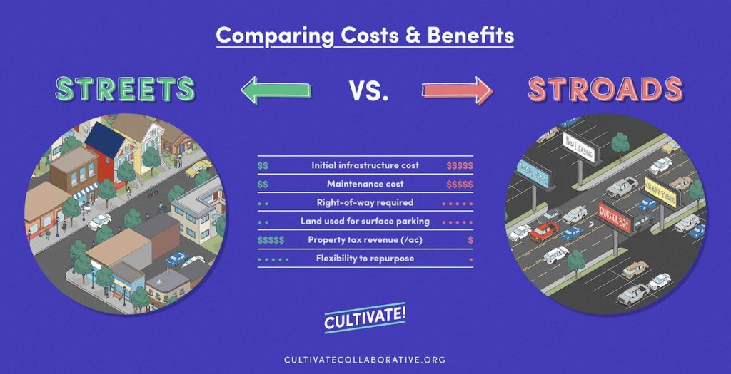
The Stroad Problem
Trouble starts when one piece of pavement tries to do both jobs of a street and a road. Chuck Marohn, founder of Strong Towns, calls it a “stroad”: the futon of transportation, this street-road hybrid is too fast to be a good street and has too many driveways and turning movements to be a good road.
In many small towns, the stroad has grown along the state highway at the edge of town, with no purpose or intention to its design behind the usual AASHTO Green Book and the Manual on Uniform Traffic Control Devices. The road was built to connect places. Then, one parcel at a time, businesses located along it for the visibility and the passing traffic: a gas station, a fast-food restaurant, a dollar store, a farm supply store. Each got its own driveway and its own parking lot. As turning traffic grew, the road was widened and a turn lane added. Each decision made sense on its own. Together, they produced a corridor that serves neither purpose well.
Those compromises affect everyone using the corridor. Traffic isn’t efficient, because every business entrance is a potential conflict. And the street isn’t productive, because few people want to walk, sit, or linger next to traffic moving at highway speed. Each business sits on its own island of parking, and walking to the one next door, let alone across the road, often means crossing several lanes without a sidewalk or crosswalk. So people drive a few hundred feet instead, adding still more turning traffic.
It is also where safety problems concentrate. Stroads combine the two conditions that make crashes both likely and severe: many points where vehicles turn across each other’s paths, and speeds high enough to make those conflicts dangerous. The risk rises fastest for people outside a vehicle. A pedestrian struck at a higher speed is far less likely to survive. And design shapes behavior far more than signs do. If a street looks and feels like a highway, people will drive it like one, whatever the posted limit says.
That is why a stroad is less an engineering accident than a planning outcome. It is what a corridor becomes when no one decides what it is for.
Recognizing the stroad—and fixing it
The plans in this set describe the pattern without using the word. Raton, New Mexico, identifies the junction of I-25 and US 64/87 at Exit 451 as the largest contributor to traffic congestion in the city. It is a popular stop for travelers looking for a meal or a room for the night, and the plan describes an obsolete interchange “constrained by frontage roads in three quadrants and service stations with multiple driveways on all four sides.” During busy summer months, traffic can back up to the Interstate’s through lanes. The businesses depend on the highway, and the highway’s performance is now limited by the businesses. That is a stroad at an interchange.
Bernalillo offers a sharper example. US 550, the four-lane route to the Four Corners, carried more than 45,000 vehicles a day at the Rio Grande bridge in 2019, and it is where most of the town’s crashes occur. Crashes at its intersection with Camino del Pueblo rose from 49 in 2010–2012 to 121 in 2017–2019; at Camino Don Tomas, from 30 to 120. Some of that increase likely reflects years of construction, as the plan acknowledges. But the response is instructive. NMDOT has widened the highway to six lanes with raised medians, added restricted-crossing U-turns that require side-street drivers to turn right and then make a U-turn at a dedicated signal, and built New Mexico’s first continuous-flow intersection at NM 528. The state has chosen to make US 550 more of a road. The plan sensibly recommends comparing crash rates once regular drivers have adapted.
Ruidoso Downs shows the opposite predicament. US 70 is the city’s only arterial: a four-lane divided state highway and a designated New Mexico Priority Freight Corridor, with relatively frequent at-grade intersections. It is also, in effect, the city’s main street. The only public sidewalks in town run along US 70, and the city earns a Walk Score of 15. The plan does not try to fight the highway’s freight role. Instead, it asks NMDOT for a phased streetscape plan—wider sidewalks, ADA-compliant ramps, pedestrian crossings, landscaping, lighting, and bike lanes where feasible—along with traffic control standards and access policies for the corridor.
Fixing a stroad starts with deciding its primary job, then choosing tools that fit that job. Where movement comes first, the plans lean on a familiar toolkit:
- Access management. Fewer, better-placed driveways. FHWA counts corridor access management among its Proven Safety Countermeasures, citing reductions of 5 to 23 percent in total crashes on two-lane rural roads and 25 to 31 percent in fatal and injury crashes on urban and suburban arterials when driveway density is reduced. Grand Island’s plan lists access management projects on State Street, 13th Street, and Faidley Avenue west of US 281 among the MPO’s short-term priorities.
- Backage roads. For years, the standard answer to strip development was a frontage road running right alongside the highway. Clay County’s 2025 plan notes that experience has shown “backage roads” to be more effective: local access built a block or so off the highway, connecting to it at fewer points. Grand Island’s plan expects new development to “provide access improvements and a backage road system along major roadways.” Raton’s Exit 451, hemmed in by frontage roads, shows how the older approach can crowd an interchange.
- Consolidated access and alleys. Grand Island and Hall County both encourage “consolidated access along section roads, rather than individual driveways.” Grand Island adds what may be the oldest access-management tool in town: “Preserve alley access city-wide, to reduce need for curb cuts.” The alley is the original backage road.
- Safer crossings on four-lane highways. Thayer County’s plan describes a $4.4 million Highway Safety Improvement Program project on US 81 near Hebron that would replace four existing intersections with restricted crossing U-turn (RCUT) intersections. Side-street drivers turn right and make a U-turn at a median opening rather than crossing four lanes of traffic. FHWA estimates that converting a two-way stop-controlled intersection to an RCUT reduces fatal and injury crashes by 54 percent.
- Better two-lane roads. Not every highway needs four lanes. According to Hall County’s plan, NDOT is designing a “Super 2” upgrade of US 30 between Grand Island and Kearney—two lanes with paved shoulders and passing lanes about every five miles—for a forecast 7,825 vehicles a day in 2035. A Super 2 improves a rural road’s ability to do its job without the cost and footprint of a four-lane expressway.
Where access comes first, the tools change. A road diet—typically converting four undivided lanes into two through lanes and a center turn lane—frees room for on-street parking, bike lanes, or wider sidewalks, and FHWA’s Road Diet Informational Guide reports expected crash reductions of 19 to 47 percent. Aztec, New Mexico, plans exactly that for Main Avenue downtown, as discussed below.
Grand Island’s plan raises one more design choice worth a hard look. Through downtown, US 30 follows a one-way pair on First and Second Streets. “One-way streets promise greater traffic capacity,” the plan observes, “yet also encourage speeding and detract from accessibility to business along these streets. Many cities are eliminating one-way pairs and returning to two-way streets in the interest of traffic calming and economic development downtown.” A one-way pair is a road solution applied to a street. Whether it still fits depends on what the town wants downtown to become—which is, again, a comprehensive-plan question.

A Dutch Illustration: Make each road’s role clear
The Netherlands offers a useful illustration of what it looks like to make a road’s purpose explicit. Under its long-standing Sustainable Safety (Duurzaam Veilig) approach, the Dutch classify roads by function: through roads built for traffic flow, access roads that serve homes and businesses, and, in between, distributor roads that connect the two.
The aim is to make each road’s intended role clear through its design: where traffic should flow, where it should connect, and where local access takes priority.
Speed limits follow the same logic. Outside built-up areas, distributor roads are typically limited to 80 km/h (about 50 mph) and access roads to 60 km/h (about 37 mph). Inside towns, distributor roads usually carry 50 km/h (about 30 mph), while local access streets are generally designed for 30 km/h (about 20 mph).
Dutch guidelines tie each category to consistent visual cues, especially pavement markings. A rural distributor road typically has a solid double center line. A rural access road typically has no center line at all, with dashed edge lines where the road is wide enough. The markings are meant to help drivers recognize the road’s function before they need to look for a speed-limit sign.
That middle category is where the lesson for American main streets lies. When through traffic reaches a built-up place, somebody has to decide which function gets priority. The Dutch answer is to make that decision explicitly and then design for it, rather than letting a highway quietly carry on through town. Where a distributor road enters a village, the change may be marked at the town boundary by a roundabout or a narrowed entrance, at the point where the limit drops to 50.
Some Dutch villages have gone a step further: they built a bypass for through traffic and redesigned the old main road as a slower street oriented to the homes and shops along it. American towns know the risk of that approach, since a bypass can pull businesses away from downtown toward the new highway. The difference lies in what happens next. A bypass only helps a main street if the town decides what the old road should become, and plans the land along the bypass accordingly.
Bypasses closer to home
American examples are closer than the Netherlands. In Kimball, Nebraska, Chestnut Street carried State Highway 71 through the heart of town until the highway moved to a bypass on the east side, with a new bridge over the Union Pacific tracks and US 30. Chestnut Street is now classified as a minor arterial, and Kimball’s 2024 plan describes it as functioning “in many ways as the city’s ‘Main Street’ through the downtown core.” It still passes beneath the railroad through an Art Deco underpass that has been recommended as eligible for the National Register of Historic Places. Highway 71, meanwhile, carries Heartland Expressway traffic between Scottsbluff and Colorado, and the corridor plan recommends extending the bypass south of town. The old road and the new one are each free to do their own job.
Aztec, New Mexico, is in the middle of that transition. US 550 runs through downtown as Main Avenue, carrying heavy truck traffic between Bloomfield and Durango. The city has been working with NMDOT on the East Aztec Arterial, a two-lane route intended to take through traffic—especially trucks—off Main Avenue. Our Aztec (New Mexico) Comprehensive Plan (2021) lays out the sequence: complete the arterial, move the US 550 designation to it, transfer ownership of Main Avenue from NMDOT to the city, and then build a Complete Street and road diet downtown, for which the state appropriated $100,000 for study and improvements in 2021. A North Main Extension would create a pedestrian-friendly commercial street between downtown and the Animas River, with civic space for events such as the summer farmers market and trail connections across the river to Aztec Ruins National Monument.
Aztec’s plan also names the risk raised above. The East Aztec Arterial will cross private land that is currently landlocked, and “careful land use planning, access management, and extension of supporting infrastructure will be required for future development to preserve the function of the East Aztec Arterial as a highway bypass.” Put simply, if the new road fills up with driveways, the town will have built itself a new stroad and moved the old problem across town.
Grand Island faces both halves of the question at once. In November 2025, NDOT opened a four-mile realignment of US 30 on the city’s west side, and the city will use the old section of US 30 as a city street, according to Midwest Contractor. The comprehensive plan expects the realignment to “likely have effects on future land use between the village of Alda and city of Grand Island.” Further out is a potential East Bypass, the largest unfunded High Priority Vision project in the MPO’s long-range plan, which would divert traffic from South Locust Street near Wildwood Drive around the east side of the city to the airport and on to US 281 north of Capital Avenue. NDOT has dedicated Build Nebraska Act funding to preliminary design and forecasts about 8,800 vehicles a day in 2035. The plan is candid that such a project “would have a substantial impact on both existing and future land use and development across the city,” and it directs the city to engage NDOT on design “to assure local needs are met and impacts on existing residents are minimized” (Action 15.2.5).
The lesson from all three is that a bypass is a land-use decision dressed up as a highway project. The plan should say what the old road will become and how the land along the new one will be zoned, served, and accessed—preferably before the right-of-way is bought.
Technology can help—but it cannot decide
The Dutch example also raises a modern question for American communities: what can technology do to help roads perform their intended function? In the 1990s, transportation agencies called this field Intelligent Vehicle-Highway Systems, or IVHS. Today, the more common term is Intelligent Transportation Systems, or ITS. The name has changed, but the basic idea remains the same: use sensors, communications, signs, data, and vehicle-to-infrastructure connections to make travel safer, more predictable, and more efficient.
For a small town, that can mean practical tools rather than science fiction. A speed-feedback sign can tell an approaching driver, “You are doing 48 in a 35.” A pavement sensor can activate a warning sign when a vehicle approaches a busy crosswalk. An intersection can adjust signal timing for a school dismissal, a freight movement, or an emergency vehicle. Dynamic message signs can warn drivers about a crash, floodwater, a closed bridge, smoke, ice, or a detour ahead. On a rural highway, those are useful tools—especially where weather, farm equipment, wildlife, long distances, or limited emergency-response capacity make a mistake more consequential.
The next step is connected-vehicle technology: roadside units that exchange information with equipped vehicles or third-party applications. In principle, a town approach could warn a driver about a sharp curve, a stopped school bus, an emergency vehicle, a work zone, an icy bridge deck, or a pedestrian in a marked crossing before that driver can see the hazard clearly. The technology is no longer confined to a laboratory. State DOTs are deploying roadside units along signalized intersections, interstate routes, and rural corridors; Utah, Colorado, and Wyoming, for example, are expanding interoperable vehicle-to-everything systems along a multistate network.
Some small towns already sit inside these networks. In Bernalillo, the Mid-Region MPO’s long-range plan designates I-25, US 550, and NM 528 as Intelligent Transportation Systems priority corridors, where investments such as real-time traveler information and commercial vehicle and freight management communications are planned.
But ITS cannot solve a stroad by itself. A flashing sign may remind drivers to slow down. It cannot make a wide, straight, driveway-filled corridor feel like a town street. A connected vehicle may warn of a pedestrian crossing ahead. It cannot replace a sidewalk, a refuge island, a sensible crossing location, or land-use decisions that stop adding turning conflicts one parcel at a time.
That is the planning test: use technology to support a clear transportation purpose, not to avoid making one. If a corridor is meant to remain a high-speed regional connection, ITS can help manage incidents and warn drivers before conditions change. If it is meant to become a town street, the design still has to establish lower speeds, safer crossings, and a built environment that tells drivers they have arrived. Technology is most useful when it reinforces what the road already says.

The Edge of Town: What Drivers Feel and What They See
The distinction between streets and roads becomes hardest, and most consequential, where a highway enters town. There, a community has to decide where movement gives way to access—and make that decision visible in the street itself.
A real community gateway is not just a welcome sign, although a well-made sign can be part of one. It is the place where the physical environment begins to tell drivers that they have entered a different kind of place: a place with people walking, children crossing, businesses opening onto the street, homes nearby, and public spaces worth paying attention to. It is a first impression, but it is also a safety treatment, a land-use decision, and an economic-development statement.
A good gateway tells drivers, physically, that the rules have changed. Travel lanes may narrow. Curbs and sidewalks may appear. Street trees, lighting, buildings, and parked cars may move closer to the roadway. A median, refuge island, roundabout, or a change in pavement texture may interrupt the long, straight view ahead. The point is not to make a driver nervous. It is to make the driver attentive.
None of this requires a monument or a fountain. A town can spend a great deal of money on decorative signage while leaving the actual road unchanged. That may improve the photograph, but it does little to change how fast people drive through town. The more durable approach is to make the roadway itself communicate the transition from rural travel to a place where access, safety, and local activity matter.
Federal Highway Administration research on main roads through rural communities makes the same basic point. Small communities often sit on highways that serve two very different purposes: outside town, the road carries faster long-distance traffic; inside the built-up area, it must accommodate driveways, crossings, pedestrians, bicycles, parking, and local businesses. FHWA found that relying on enforcement alone tends to produce only temporary compliance. A more lasting approach is to change the look and feel of the roadway so drivers recognize that its function has changed.

A Gateway is a Sequence
Where the transition happens matters as much as how it happens. A welcome sign may mark a municipal boundary, but that boundary may have little to do with where the town actually begins. After years of annexation, highway-oriented development, and strip commercial growth, the sign may stand well before the place people recognize as town. Or it may stand after drivers have already passed the first businesses, subdivisions, school entrances, and turning movements that require lower speeds and more attention.
Here in the county seat near where I live, when you come in from the south you hit city limits about a mile before anything is built yet… then the speed limit drops from 65 to 35 in a matter of feet in a school zone. Yet on the north side of town, the speed limit stays at 65 well into town itself. It only makes sense in the mind of the State Department of Highways.
This is not an argument that every community entrance should be manicured, expensive, or free of commerce. Small towns need gas stations, motels, repair shops, farm-supply stores, restaurants, local advertisers, and directional signs. Those businesses are part of the local economy, and a highway corridor may be the only place where some of them can reasonably locate.
Interstate interchanges are a special case. They are often the first thing a traveler sees of a town, and they have a highway-service job of their own: fuel, food, lodging, repairs, and the truck parking that Hall County’s plan calls for when I-80 closes. Raton’s Exit 451 is the city’s front door for I-25 travelers and also its worst bottleneck. Planning those entrances means accepting their highway-service role while still deciding where, beyond the ramps, the road begins to act like part of town.
A gateway works best where the built environment begins to change—or where the community wants it to begin.
And it is rarely a single point. Entrances work better when they step drivers down in stages:
- First comes the rural highway, where long-distance travel is still the primary purpose.
- Then comes a transition area, where drivers begin to encounter development, turning movements, crossings, or other evidence that the road is approaching a town.
- Finally comes the town street, where the roadway is designed around access, lower speeds, pedestrians, businesses, and the public life along it.
That progression gives drivers time to read the environment and adjust. It is also more honest. A 25- or 30-mile-per-hour sign at the edge of an open, wide, highway-like cross section asks drivers to ignore what the road is telling them. A sequence of physical changes gives the sign some help.
The research is a useful caution, too: paint and signs alone are not always enough. In Iowa, researchers tested low-cost gateway and traffic-calming treatments in five rural communities. Some treatments, including pavement legends and painted lane narrowing, had limited or inconsistent effects. More tangible measures performed better in particular locations: speed-feedback signs in Union (pop. 400) and Slater (pop. 1,600) reduced observed 85th-percentile speeds by as much as 7 mph, while a high-visibility entrance treatment at Dexter (pop. 640) reduced speeds by 4 to 9 mph at some locations. The practical lesson is not that every town needs a roundabout or a major reconstruction. It is that a gateway should be a coordinated set of cues, and the most effective cues tend to have some physical presence.
Gateways in the plans
Grand Island’s plan makes the entrance an explicit action: “Maintain and improve community entrances to Grand Island along major corridors” (Action 15.2.7), with the city, Hall County, and Nebraska DOT named as the responsible organizations. That short sentence matters. It puts the entrance corridors on the city’s work list, names the state as a partner, and gives staff a policy basis to raise entrance design whenever a highway project, annexation, or development proposal comes forward along one of those corridors.
Bernalillo shows what the town-street end of the sequence can look like on a state highway. Camino del Pueblo (NM 313) follows the old route of US 85 along the Rio Grande and functions as the town’s “Main Street,” lined with commercial, institutional, and residential buildings. It carries 9,000 to 10,000 vehicles a day—a fraction of US 550’s volume. On-street parking along much of its length helps calm traffic, makes walking more pleasant, and supports local businesses. Working with NMDOT, the town has rebuilt it in phases, adding ADA-compliant sidewalks and signalized mid-block pedestrian crossings with refuge islands at El Zocalo Plaza, Town Hall, and a commercial cluster. Two highways meet in Bernalillo, and the town has let each one do a different job.
Aztec’s plan, meanwhile, captures a gateway principle in a single strategy: build new median projects “to help beautify the community and encourage slower travel speeds.” The landscaping is not decoration for its own sake. It is meant to do some of the work of telling drivers where they are.

Signage and Billboards
The edge of town is also a first impression. It shapes how visitors, business owners, and potential residents judge a place, and whether they stop at all. A town entrance lined with billboards, vacant lots, and scattered signs tells a different story than one where the road narrows toward a recognizable main street.
But there is a difference between helping people find services they need and allowing every parcel to compete for attention at full volume, screaming into the void in capital letters and neon.
When each business installs its own large sign, freestanding reader board, flag, banner, lighting package, and driveway marker, the result is rarely a stronger commercial corridor. It is visual competition. Each sign may make sense on its own. Together, they can make it harder to see the signs that matter, harder to read the road ahead, and harder for a visitor to understand where the town begins or where its center is.
The problem is especially acute at the edge of town, where drivers are already processing a great deal of information. They may be adjusting to a lower speed limit, watching for a turn, looking for fuel or food, encountering driveways and turning vehicles, noticing pedestrians, and trying to understand whether they are entering a commercial strip, a downtown, or a residential neighborhood. A corridor full of competing messages adds to that workload.
A well-designed gateway does the opposite. It helps organize information. It makes the travel lane, sidewalk, crosswalk, business entrance, and town center easier to read. It gives local businesses a setting in which their signs can be seen without requiring each one to be taller, brighter, or more animated than the last.
Billboards and distraction
Billboards raise a separate concern because they are designed to draw attention away from the driving task. That is not an attack on advertising; it is the basic purpose of advertising. The safety question is whether a sign’s location, size, brightness, movement, or frequency of message changes demands attention at the same moment a driver needs to watch the road.
The research is not as neat as either side of the billboard debate sometimes suggests. It is difficult to isolate the effect of a single billboard from the surrounding traffic, roadway design, land uses, weather, lighting, driver behavior, and crash-reporting limitations. Some studies have not found a clear causal relationship between billboard presence and crashes. The outdoor-advertising industry, for example, points to field research indicating that drivers generally keep most of their visual attention on the forward roadway.
Still, the broader safety concern is not imaginary. Research finds active billboards draw more glances and more long glances than conventional static signs. That’s the reason businesses invest in signs, yet those same studies conclude that roadside advertising also creates a modest but non-negligible safety risk through distraction—especially when a driver suddenly encounters a complex situation after a period of relatively simple driving. That description should sound familiar to anyone thinking about the entrance to a small town: a fast rural highway can quickly become a corridor with driveways, turning traffic, intersections, pedestrians, and lower expected speeds.
A 2015 multi-state study of digital billboards in Alabama and Florida found that crash rates were higher in areas within the influence of the digital signs than in comparison areas downstream. That finding does not prove that every digital billboard causes crashes, and it should not be treated as a universal formula. It does reinforce the common-sense concern that changing, illuminated, attention-seeking signs deserve more caution than a static, well-placed business sign.
Recent research from Texas makes the point plainly: outdoor advertising is intended to attract driver attention, which can take attention away from driving. The study examined conventional and digital billboards, including nighttime illumination and the effects of changing content, and called for regulation that keeps pace with changing sign technology.
In Grand Island’s plan, we cite one of the more striking findings, as reported by Colorado engineering professor Wes Marshall, in his book Killed by a Traffic Engineer. On the Ayalon Highway in Tel Aviv, Israeli researchers compared crash records while billboards were present, covered, and then restored. Covering the billboards was associated with a 30 to 40 percent reduction in injury crashes, and restoring them with a substantial increase, according to Scenic America’s summary of the Gitelman study. One urban freeway is not a small-town highway, and a single study should not carry too much weight. But it fits the broader pattern: signs designed to capture attention tend to succeed.
The practical planning lesson is simple. A community does not need to prove that every billboard is dangerous before deciding that a busy town entrance is not the right place for an additional visual distraction. The case for sign regulation is not only crash reduction. It is also legibility, community character, economic development, and the ability of drivers to recognize the transition from highway to town.
What the federal law does—and does not do
In the United States, part of this landscape is governed by the Highway Beautification Act of 1965. Congress declared that outdoor advertising along the Interstate and primary highway systems should be controlled to protect the public investment in highways, promote the safety and recreational value of travel, and preserve natural beauty. States that do not provide “effective control” of outdoor advertising along covered routes risk a reduction in federal-aid highway funds.
The law matters, but it is not a complete answer for a local gateway corridor.
The Highway Beautification Act establishes the federal-state framework for billboards near covered highways. It does not create a universal prohibition on outdoor advertising, and it leaves significant room for state agreements, permitting systems, grandfathered signs, on-premises signs, and signs in commercial or industrial areas. In practice, a community can enter town on a federal-aid highway and still encounter a substantial amount of legally permitted signage.
One detail of the federal framework is especially relevant at the edge of town. As the Grand Island and Hall County plans note, the so-called Kerr Amendment allowed outdoor advertising in commercial and industrial zones along covered highways. Those are exactly the zones that tend to line highway entrances. Zoning decisions along an entrance corridor can therefore affect not only what gets built there, but where billboards may be eligible under state law.
It also does not govern every road that concerns a town. On local streets, county roads, and many locally significant entrance corridors, what drivers see depends largely on state law and local sign codes. Even along a state highway, local zoning, development standards, annexation decisions, and sign regulations can affect the number, placement, size, height, lighting, and design of signs associated with businesses and new development.
That is why sign policy belongs in the comprehensive plan conversation. A community should not wait until one proposed billboard or electronic message center triggers a dispute. By then, the debate often becomes a narrow argument about one parcel, one business, or one applicant. The better time to decide is earlier, when the town can ask what it wants its entrances to communicate and how signage should fit into the whole corridor.
The French example
France addresses part of the same issue through separate controls on the landscape outside town. Outdoor advertising outside built-up areas is prohibited in principle, with limited exceptions. Rules associated with the Loi Barnier also restrict new construction along certain major roads outside urbanized areas. A town seeking different setback rules must justify them with a planning study that addresses safety, nuisances, and the architectural and landscape quality of the entrance.
Neither is a “gateway law” on its own, and neither has solved the problem. France has its own version of the strip: the commercial zone of big-box stores, parking lots, and roundabouts at the edge of town. Concern about those entrees de ville is part of what led to the setback rules in the first place.
What the two instruments do is keep billboards away from rural roads and require a deliberate justification before new construction crowds certain major roads. The decision about what an entrance should become still has to be made locally.
Remember the First Amendment
Many local sign codes were written decades ago, and some may no longer hold up in court. In Reed v. Town of Gilbert (2015), the U.S. Supreme Court struck down a sign code that treated signs differently based on what they said. Content-neutral regulation is essential for compliance with the First Amendment to the U.S. Constitution. In City of Austin v. Reagan National Advertising (2022), the Court clarified that: distinguishing between on-premises and off-premises signs (billboards) is not, by itself, content-based.
The practical advice is straightforward: have your older sign code reviewed by an attorney as well as a planner, then get busy bringing it up-to-date.
Several of the plans I’ve worked on make that recommendation directly. In Burwell’s plan, we suggested the city review its sign code “to offer greater protection to adjacent property values.” In reality, we adjusted within what the Planning Commission and City Council were willing to enforce. In Clay County, we suggest revisiting current signage rules “to assure conformance with the latest case law.” Both cite City of Austin as confirmation that local sign codes may continue to strictly regulate off-premises advertising.
Towns also have tools of their own. One is a corridor or gateway overlay district: a zoning layer along the main entrances that can set standards for building placement, parking, landscaping, and signs. It lets a town shape the approach it wants without rewriting the rules for the whole community.

What This Means for your Comprehensive Plan
A comprehensive plan is the right place to decide what each road into town is supposed to do. It can establish the community’s intent before individual access permits, development proposals, sign requests, resurfacing projects, or bypass discussions make that decision incrementally.
- Decide what each corridor is for. Functional classification describes a road’s role in moving traffic and providing access. Your plan should add the community’s intent: where movement takes priority, where access does, and what the land along each corridor is meant to become.
- Check the map against the street. Where streets function above or below their classification, work with your MPO, regional planning organization, or state DOT to update the map, as Ruidoso Downs proposes.
- Compare what development patterns return. Where the data allow, look at the taxable value per acre of downtown blocks and corridor development, alongside what their streets and utilities cost to maintain.
- Review the street budget against the plan every year. In Nebraska, that means the One- and Six-Year Plan; elsewhere, the capital improvements plan. That is where intent becomes pavement.
- Right-size the pavement. Review street standards for required widths, as Grand Island’s plan directs. Narrower local streets cost less to maintain and encourage slower driving.
- Locate your gateways. Mark where the highway should begin to behave like a town street, show that transition in the comprehensive plan, and consider a corridor overlay to guide development along the approach.
- Coordinate with your state DOT early. If your main street is also a state highway, redesign depends on the state’s cooperation. Get the town’s goals into the plan before the next resurfacing project is scheduled; restriping during resurfacing is often the least expensive moment to change how a road looks and feels.
- Manage access along entry corridors. Fewer, better-placed driveways make the approach safer and preserve room for a real transition.
- Plan backage roads, shared access, and alleys. Expect new development along major roads to consolidate driveways and connect behind the frontage, and preserve alleys to reduce curb cuts.
- Plan a bypass and the old road together. If a bypass exists or is proposed, decide what the old main road should become, and how the land along the new route will be zoned.
- Name your lifeline routes. Identify evacuation routes and flood-prone road segments with your hazard mitigation plan, and keep those corridors working as roads.
- Review your sign code. Check it against current case law, and make sure it supports the first impression the town wants to give.

Where the Road Meets the Town
Every town on a highway has a place where the road meets the town. Sometimes it is a roundabout, a row of street trees, or a block where the buildings step up to the sidewalk and drivers instinctively ease off the gas. More often, it is simply wherever the speed-limit sign happened to be planted decades ago, by someone who never had to cross that road on foot. In too many communities, no one decides what should happen at that point. It just happens, one driveway, one sign permit, and one resurfacing project at a time.
The places in this post show that it doesn’t have to. In Grand Island, we wrote in the distinction between streets and roads into two policies and made its community entrances an action item. Kimball let its old highway become a main street once the bypass took the through traffic. Aztec is building a bypass and planning the road diet that should follow, while warning itself not to let the new route fill up with driveways. Bernalillo allowed one highway to become more of a road and the other more of a street. None of that work is finished, and every piece of it depends on a state DOT. But each effort started with a plan that said, in plain language, what the corridor was for.
The Netherlands and France reach the same lesson by different routes: road function, the design of the town entrance, roadside development, and visual character cannot be treated as unrelated decisions. For a planning commission or a city council, that lesson is practical rather than abstract. It shapes how you review the One- and Six-Year Plan, how you respond when the DOT schedules a resurfacing, what you require of the next commercial plat along the highway, and whether your sign code helps or hurts the first impression your town makes.
So before the next project is scheduled, put one question on the agenda and expect your comprehensive plan to answer it: Where, exactly, should the highway begin to behave like a town street? The answer will differ at every entrance, and it may take patient negotiation with the state, the county, and the property owners along the way. But a community that can point to that spot on a map, and explain why it belongs there, has already done the hardest part of the work.
Next Sunday: Beyond the automobile. Multimodal systems for transit, bikes, sidewalks, and trails.
John C. Shepard, AICP, is a planner and economic development practitioner with more than thirty years in public-sector and consulting practice, and is incoming chair of the American Planning Association’s Small Town and Rural Planning Division. The views expressed here are his own.

Further Reading
Sources and background
- Strong Towns — Safe & Productive Streets: https://www.strongtowns.org/streets
- Strong Towns — What is a STROAD and why does it matter?: https://www.strongtowns.org/journal/2018-3-1-whats-a-stroad-and-why-does-it-matter
- Urban3 — Redlands, California case study: https://www.urbanthree.com/case-study/redlands-ca/
- Federal Highway Administration — Corridor Access Management (Proven Safety Countermeasures): https://highways.dot.gov/safety/proven-safety-countermeasures/corridor-access-management
- Federal Highway Administration — Traffic Calming on Main Roads Through Rural Communities (2008): https://www.fhwa.dot.gov/publications/research/safety/08067/
- Federal Highway Administration — Outdoor advertising control: https://www.fhwa.dot.gov/policy/olsp/fundingfederalaid/d.cfm
- U.S. Supreme Court — City of Austin v. Reagan National Advertising (2022): https://www.supremecourt.gov/opinions/21pdf/20-1029_i42k.pdf
- SWOV — Principles for a safe road network: https://swov.nl/en/fact-sheet/principles-safe-road-network (behind Cloudfare filter)
- SWOV — Recognizable road design (fact sheet): https://swov.nl/system/files/publication-downloads/fs_recognizable_road_design_archived.pdf (behind Cloudfare filter)
- Légifrance — Code de l’environnement, outdoor advertising outside built-up areas (in French, behind Cloudfare filter): https://www.legifrance.gouv.fr/codes/article_lc/LEGIARTI000031966585
- French Senate — report on the entrées de ville and the 1995 Dupont amendment (in French): https://www.senat.fr/rap/l09-128/l09-1281.html
Books
- Killed by a Traffic Engineer: Shattering the Delusion that Science Underlies our Transportation System by Wes Marshall (Island Press, 2024)
Translates engineer-speak into plain English, and the obfuscation of engineer data into plain facts you need to know to save lives in your community. Read a short excerpt on the blog here. Top entry in our 12 Planning Books recommended for 2025. - Confessions of A Recovering Engineer: Transportation for a Strong Town by Charles Marohn (Wiley, 2021)
Chuck Marohn delivers a vision for more accessible and engaging local transportation systems in his second book in the Strong Towns series. He delivers withering critiques of his chosen profession, yet also offers real-world examples of communities doing better for all residents. Our October 2026 featured book of the month. - Strong Towns: A Bottom-Up Revolution to Rebuild American Prosperity by Charles Marohn (Wiley, 2019)
Advocates for fiscally sound, community-focused development. Our December 2025 book of the month. - Street Design: The Secret to Great Cities and Towns by Victor Dover and John Massengale (Wiley, 2013)
It is practical and richly illustrated, useful for anyone designing a main street. - Walkable City: How Downtown Can Save America, One Step at a Time by Jeff Speck (Farrar, Straus and Giroux, 2012)
A readable case for streets designed for people, and it also bridges to next week’s article.
As an Amazon Associate, jcshepard.com earns from qualifying purchases. This does not affect the price you pay or our recommendations.
Resources
Rural-Ready Engagement: Practical Tools for Small Town Planners
 Watch the full replay: youtube.com/@Engaging-Communities (February 2026). Community engagement can look very different in small towns and rural communities. This webcast was co-sponsored by the APA Community Engagement Interest Group and the Small Town & Rural Planning Division.
Dynamic Decisions Podcast (Season 2 Episode 15)
“Stop Chasing Smokestacks. Grow What You Have” with Teasha Cable of cModel Data, now playing on Youtube (audio), Apple Podcasts, Spotify (May 2026). Other listening links here.
The Rural Impact Podcast (Episode #86)
“Pathways to Powering Rural America” My guest spot on Michelle Rathman’s podcast. Episode page here, listen on Apple Podcasts or Spotify, or watch (!) on youtube. We talked about energy, data centers, and good governance, plus so much more.
Popular posts on JCShepard.com
- The Planning Process—From Vision to Action in Small Towns and Rural America (January 2026)
- Historic Preservation and Rural Economic Development: A Rural Growth Strategy (April 2026)
- Small Towns Can Build a Strong Outdoor Economy Without Selling Out (June 2026)
- The Rise of Rural Entrepreneurship: Building Economies from the Ground Up (January 2026 on Medium.com)
- When the Zoning Code Works Against the Plan (September 2026 just last month!)
- Reviving Rural America: Why Heritage Tourism Is a Game-Changer Now (September 2025)
- What is Economic Development in Modern America? A Field Guide for Small Towns and Rural Places (March 2026)
- Rethinking the Rural Economy: New Paths, New Possibilities for Growth (August 2025)
- How Small Towns Succeed: A Proven Playbook for Rural Action (November 2025)
- Reviving Rural America: Why Heritage Tourism Is a Game-Changer Now (September 2025)
- Is Rural Really the Same as Non-Metro? (February 2026)
- Revitalizing Main Street the Idea-Friendly Way (August 2026 on Medium.com)
- Floodplain Management and the Comprehensive Plan: Beyond the FEMA Flood Map (August 2026)
Check out The 12 Planning & Sustainability Books You Need in 2026 and browse through the Small Town & Rural Community guides on our Resources page.
.