

Part 4 of 5 in our August series on Public Safety and Hazard Mitigation in the Comprehensive Plan.
Nearly every comprehensive plan acknowledges flood risk. Too seldom do our planning processes translate that acknowledgment into effective floodplain management.
Every community has a relationship with water. Some are defined by a major river, a lake, a creek, a drainageway, or a coastline. Others may appear dry most of the year, until a stalled storm, rapid snowmelt, saturated ground, or an overwhelmed drainage system reveals where water has always intended to go.
Flooding is the nation’s most common and costly natural hazard, but it is often treated as a narrow regulatory issue: a FEMA map, a floodplain regulation, an elevation certificate, and a permit review for property inside the mapped floodplain. Those tools matter. They protect lives, support participation in the National Flood Insurance Program, and establish an essential regulatory floor. But they are not the whole flood-mitigation strategy.
A FEMA Flood Insurance Rate Map tells a community where federal flood-insurance requirements apply. It does not necessarily show the full extent of current or future flood risk. It does not capture every undersized culvert, overwhelmed storm sewer, altered drainageway, filled wetland, or upstream development decision that changes how water moves through a watershed. And it cannot answer the larger comprehensive-planning question: where should a community grow, and which lands need to remain open because they are already performing an essential public-safety function?
That question matters in cities, towns, and rural counties alike. A subdivision that appears safely outside the mapped floodplain may add runoff to a downstream neighborhood. A commercial site may meet every local drainage requirement while eliminating wetlands or low areas that once stored water during heavy rain. A road, ditch, culvert, or levee can solve a localized problem while shifting floodwater and risk somewhere else. Each decision may be technically defensible on its own. Over time, however, a series of site-level decisions can reshape an entire watershed.
Today, we examine floodplain management as more than a FEMA compliance exercise. The central argument is straightforward: communities reduce future flood losses not only through emergency response, insurance, levees, and drainage projects, but through the land-use choices they make before the next storm arrives.

Floods Are Both Natural and Man-Made
Flooding is unique among natural hazards in one important respect: it is simultaneously a natural phenomenon and a land use outcome. A river floods because rain falls, snow melts, groundwater rises, or a storm stalls over a watershed longer than anyone expected. No comprehensive plan can prevent those events. But how much water reaches the river, how quickly it arrives, where it spreads, and how much damage it causes are all shaped by land-use decisions made upstream and across the watershed over decades.
That is the distinction planners need to keep in view. Weather creates the event. The built environment helps determine the consequence.
A healthy watershed does not move every drop of rain directly into a stream. Forests, grasslands, soils, wetlands, floodplains, depressions, and vegetated stream corridors slow water down. Some rainfall infiltrates into the ground. Some is taken up by vegetation. Some is stored temporarily in wetlands, swales, ponds, and floodplain areas before draining gradually downstream. Those processes do not eliminate flooding, particularly during large events, but they reduce the speed and peak volume of runoff moving through the system.
Development changes that system, usually one site at a time. Rooftops, roads, driveways, parking lots, and compacted lawns prevent infiltration and accelerate runoff. Ditches, storm sewers, culverts, drainage tiles, and channelized streams move that water away efficiently from the individual site—but often deliver it more quickly to the next property, drainageway, or community downstream.
A watershed that was 10 percent impervious a generation ago and is now 30 percent impervious does not simply have more pavement. It has a different hydrologic response to the same storm. Water reaches streams faster, peak flows rise, channels erode more aggressively, and downstream communities have less time to react. The practical effect is that a rainfall event once absorbed or slowed by the landscape can become a flash-flood event after years of incremental development.
The same is true of floodplain encroachment. Floodplains are not vacant land waiting for a productive use. They are part of the river’s operating system: areas where water can spread, slow, and temporarily store during high-flow events. When fill, buildings, roads, parking lots, levees, or other improvements occupy that space, floodwater does not disappear. It is displaced. In some cases, it moves deeper, faster, or farther onto adjacent property. In others, it raises flood stages upstream or redirects water toward homes, farms, roads, and public infrastructure that had not previously been exposed.
Wetlands and riparian areas perform related functions. A wetland complex in an upper drainage basin can hold water long enough to reduce the sharp runoff pulse that would otherwise move downstream after a heavy rain. Vegetated stream corridors stabilize banks, filter sediment, slow overland flow, and provide hydraulic roughness that dissipates energy rather than concentrating it. Straightening a ditch or channel may appear to solve a localized drainage problem, but it often increases velocity and transfers that problem downstream.
The consequences are not always visible at the point of decision. A county approves a 150-acre commercial development outside the mapped floodplain—technically compliant, apparently safe, and perhaps well positioned for growth. The project meets the local drainage requirement, includes detention, and does not place a building in the Special Flood Hazard Area. At the site level, the approval may seem entirely reasonable.
Ten years later, however, downstream neighborhoods that had never flooded before experience repeated inundation during storms that residents remember surviving without trouble in the past. The river did not necessarily change course. The watershed changed. More runoff arrives sooner. Drainage structures designed for an earlier development pattern are undersized. Small channel alterations and filled depressions have removed storage that nobody had treated as public infrastructure. The original development may be miles away and the decision-makers who approved it may never have understood the approval as a flood-management decision.
In Grand Island, Nebraska, for example, flood mitigation has been treated as a watershed project rather than a single-site drainage problem. The Upper Prairie–Silver–Moores Flood Control Project combined stormwater detention cells, a diversion channel, and upland detention dams to reduce flood risk in the northern portion of the city. Completed in 2019, through a partnership involving the City and the Central Platte Natural Resources District, the project removed approximately 600 structures from the floodplain. During the 2019 flood event, it was estimated to have avoided $47 million in potential damage. The lesson is not that every community needs a large diversion channel. It is that upstream storage, detention, and coordinated watershed investments can protect neighborhoods long before water reaches them.
This is the cumulative-impact problem in floodplain management. No single subdivision, parking lot, agricultural drainage improvement, or commercial pad site necessarily creates a community-scale flood problem on its own. But a pattern of individually reasonable decisions can transform watershed behavior over a generation. The damage then appears downstream, after the approvals are long forgotten and when the available choices are much more expensive: larger culverts, drainage projects, buyouts, emergency response, road repairs, higher insurance costs, and repeated rebuilding.
As explored in the earlier articles on wetlands and the comprehensive plan and natural hazards, decisions that increase flood risk rarely announce themselves as flood-management decisions. A subdivision approved two miles upstream, a wetland filled for a commercial development, a roadside ditch straightened to drain a field, or a stream buffer cleared to maximize buildable area can each appear modest in isolation. Together, they reshape the flood behavior of the watershed below.
For comprehensive planners, that means floodplain management cannot be confined to the FEMA map, the floodplain ordinance, or the permit review for sites within the mapped Special Flood Hazard Area. It belongs in the future land-use map, development-area boundaries, transportation planning, stormwater standards, open-space strategy, subdivision design, capital-improvement programming, and the routine review questions asked before a site is graded or a plat is approved.
The relevant question is not only, “Is this site in the floodplain?” It is also: What will this decision do to the watershed—and who will bear the consequences when the next major rain arrives?
How Land Use Shapes Flood Risk: A Watershed Cross-Section

Each upstream land use decision reshapes flood behavior downstream. The connection is real — it is just rarely visible at the moment of approval.
Flood Events
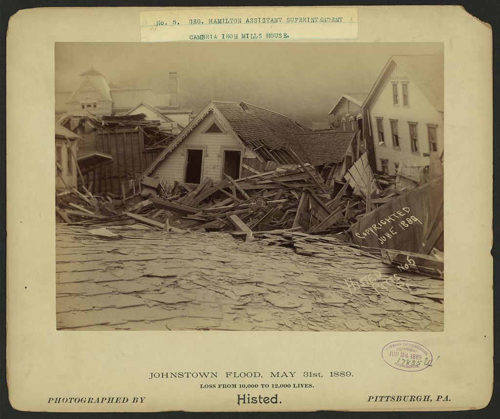
Flooding events have the potential for widespread property damage and risk of death or injury. The Great Mississippi Flood of 1927 is often regarded as the most consequential U.S. river flood, with about 500 deaths and estimated damage of up to $1 billion ($14 billion today). It inundated roughly 16 million acres across multiple states; contemporary estimates put damage above $400 million, an enormous sum for the time. The Johnstown Flood of 1889 is a legend not only in Pennsylvania where it happened but also one known by folk signers everywhere, with 2,208 fatalities and over $17 million in damage (over $500 million today).
Across the US and Canada, a few flood events in particular tell the story of how flood disasters often become planning failures or planning turning points: development in flood-prone land, watershed alteration, overreliance on structural protection, and post-disaster choices about whether to rebuild or retreat.
Hurricane Hazel, Ontario, 1954
On October 15, 1954, the remnants of Hurricane Hazel produced extreme rainfall across southern Ontario. Rivers and tributaries in the Greater Toronto area rose rapidly, particularly the Humber River, sweeping away homes, bridges, roads, and people in low-lying valley areas. Canada’s official death toll was 81, and damage exceeded $100 million in 1954 dollars.
Hazel’s importance lies in where the losses occurred. Residential development and other uses had extended into river valleys and flood-prone areas that appeared usable during ordinary conditions. But the river corridors were still part of the active flood system. When an extreme storm arrived, water occupied those corridors with destructive force.
The event fundamentally reshaped Ontario floodplain policy. Governments consolidated regional conservation-authority functions, strengthened flood-warning capability, acquired vulnerable floodplain land, expanded mapping, and changed zoning to prevent redevelopment in high-risk river-valley areas. The Toronto and Region Conservation Authority describes post-Hazel land acquisition and stricter zoning as central to limiting future development in flood-risk areas.
Planning lesson: The most reliable mitigation is often to keep the highest-hazard portions of a floodplain available for flood conveyance, storage, parks, recreation, and ecological function—not to assume that residential redevelopment can be made safe solely through site-level improvements.
Great Mississippi Flood, 1927
The Great Mississippi Flood of 1927 was the largest and longest-lasting flood on the Mississippi River to that point, resulting in approximately 500 deaths across Arkansas, Mississippi, and Louisiana. Levee failures and overtopping inundated about 11 million acres in the Delta, displaced more than 750,000 people, and exposed deep inequities in evacuation, relief, labor conditions, and recovery.
The disaster occurred in a landscape increasingly shaped by an engineering philosophy of confining the river behind levees. That “levees-only” approach treated flood control as a problem of keeping water in a narrower channel. The 1927 event demonstrated the limitations of that premise: a river basin of that scale cannot always be contained by a single line of structural defenses, and when a levee fails, the resulting flood can be abrupt and catastrophic. The event helped end the policy debate over reliance on levees alone.
Congress responded with the Flood Control Act of 1928, authorizing a comprehensive federal flood-control program for the Lower Mississippi Valley. It established the Mississippi River and Tributaries project and supported a larger system incorporating levees, spillways, outlets, floodways, reservoirs, and storage features rather than levees alone.
Planning lesson: Structural protection is valuable, but it changes rather than eliminates risk. Floodways, spillways, and designated storage areas acknowledge that high water must sometimes be accommodated. Land use within those areas should be compatible with periodic inundation, and communities behind levees must plan for residual risk if defenses are exceeded or fail.
Midwest Flood, 1993
The Midwest Flood of 1993 was a long-duration, basin-wide disaster caused by persistent heavy rainfall over much of the Upper Mississippi and Missouri River basins. Rivers stayed high for months; at St. Louis, the Mississippi remained above flood stage for 80 days. The event affected nine states, displaced about 37,000 people, and caused widespread damage to homes, farms, transportation networks, utilities, and local economies.
The flood exposed the limits of rebuilding in frequently inundated places. It also became a landmark in the evolution of U.S. nonstructural flood mitigation. Rather than directing recovery exclusively toward repairing levees and reconstructing homes, federal, state, and local governments used voluntary acquisition programs to buy flood-prone properties, remove structures, and return land to open space. FEMA reports that post-1993 buyouts became the principal action in Missouri, while broader regional programs acquired roughly 12,000 properties across nine states.
Many communities also paired acquisitions with parks, trails, habitat restoration, and flood-storage areas. This made the post-flood decision more than a housing-recovery program: it altered future land use in places where repetitive disaster had made continued occupation increasingly difficult to justify.
Planning lesson: Buyouts are not simply a post-disaster relief measure. They are a permanent land-use intervention. A comprehensive plan can identify repetitive-loss areas, floodway neighborhoods, and low-density floodplain development as future open-space, greenway, conservation, or compatible agricultural areas before the next disaster creates a rushed political decision.
Southern Alberta Floods, 2013
From June 19 to 22, 2013, exceptionally heavy rain fell across Alberta’s Rocky Mountain and foothill headwaters. Rapid runoff into the Bow, Elbow, Highwood, Sheep, and other river systems produced major flooding in Calgary, High River, Canmore, Siksika Nation, and numerous other communities. The event affected 32 local governments that declared local states of emergency.
The floods highlighted the interaction of mountain hydrology, rapidly growing urban areas, development in river corridors, and aging or limited protective infrastructure. Later assessments placed total losses at roughly CAD $4–6 billion, with limited property-level floodproofing and prior floodplain development identified as contributing factors. The event also showed that urban flood risk can be created far from the flooded block: rain falling in headwaters moved quickly through connected river systems into built-up communities downstream.
Recovery revived attention to flood-hazard management across Alberta. The policy discussion included flood mapping, structural protection, floodway and flood-fringe controls, upstream mitigation, and stronger consideration of headwaters and watershed integrity. A post-flood Alberta action compendium specifically emphasized headwaters land uses, riparian systems, and the reduction of linear disturbances—such as roads, trails, and other surface disruptions—that can reduce infiltration and increase runoff and sediment movement.
Planning lesson: Flood risk begins upstream. Municipal floodplain ordinances matter, but they are incomplete without watershed-scale coordination involving headwaters, riparian areas, wetlands, stormwater systems, regional growth patterns, and the development decisions of neighboring local governments.
Red River Flood and Grand Forks Fire, 1997
The 1997 Red River flood followed a winter of heavy snowfall and spring conditions that produced rapid melt and major runoff in the exceptionally flat Red River Valley. The Red River of the North reached a record crest at Grand Forks, North Dakota, on April 22nd, after dikes were breached and the city was inundated. The highest daily flow was recorded on April 18, and the eventual peak stage reached 54.35 feet.
The event became especially memorable because flooding and infrastructure failure cascaded into a downtown fire. Floodwaters damaged the water plant, reducing firefighting capacity; an electrical fire began in the downtown area and ultimately gutted much of the business district. The flood and fire affected the Grand Forks Herald building as well as numerous other properties. More than 50,000 residents of Grand Forks and East Grand Forks were evacuated; I hosted evacuees in my spare room further upstream. Reported damages exceeded $3.6 billion across the two cities.
The recovery is a major example of rebuilding differently. Grand Forks used voluntary buyouts to remove approximately 850 high-risk properties, while Grand Forks and East Grand Forks removed entire neighborhoods to make room for a federally funded levee system and an approximately 2,200-acre riverfront greenway of parks and open space. That greenway helped prevent comparable structural damage when another severe flood occurred in 2009.
📋 Planning Takeaway: Mitigation Is Not One Project
Flood mitigation must consider cascading failures. Flood waters can disable drinking-water facilities, power systems, transportation routes, communications, emergency access, and firefighting capacity at the same time. In recovery, the Greenway illustrates how acquisition, open space, recreation, ecosystem function, and flood storage can be combined into a durable redevelopment strategy.
Flood mitigation in the plans I have worked on in Nebraska has ranged from regional detention cells, diversion channels, and upland dams in Grand Island and Hall County to bridge replacement, culvert upsizing, drainage maintenance, flood-risk studies, and emergency-access planning in rural Thayer and Clay Counties. The appropriate response depends on the watershed and the community. But each example begins with the same recognition: flood risk is shaped by the relationship among land use, runoff, infrastructure capacity, floodplain storage, and the location of people and critical facilities.
Reading the FIRM — and Understanding Its Limits
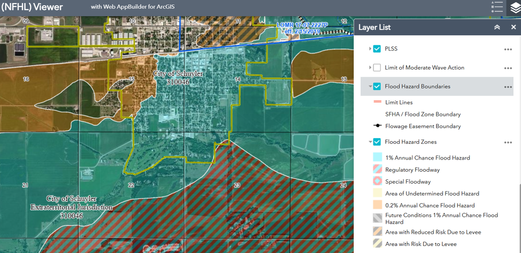
The Flood Insurance Rate Map (FIRM) is the foundation of floodplain regulation in the United States. It defines the Special Flood Hazard Area (SFHA) — the area with a one percent annual chance of flooding, commonly called the 100-year floodplain — and establishes the base flood elevation (BFE) that structures in the SFHA must meet or exceed.
For most communities, NFIP participation means adopting and enforcing a floodplain management ordinance that meets FEMA’s minimum standards: no development in the floodway, new structures elevated to or above the BFE, substantial improvement rules that require upgraded flood protection when existing structures are significantly renovated. These minimums exist to qualify residents for federally backed flood insurance. Some states go above and beyond that standard, but remember: the numbers are not designed to minimize flood damage — they are designed to minimize the insurance program’s liability.
That distinction matters enormously for comprehensive planners. A community that does exactly what NFIP requires is still approving development that will flood — it’s just approving development that has been elevated above a flood level calculated from historical data, using maps that may be decades old, in a climate where extreme precipitation events seem to be becoming more frequent and more intense.
The FIRM has additional limitations planners should understand:
FIRM maps are often outdated. Many communities are regulated by FIRMs that are twenty or thirty years old and do not reflect current development patterns, watershed conditions, or updated hydrologic data. Structures built in compliance with an old FIRM may be significantly more flood-prone than the map suggests.
FIRM maps show regulatory flood boundaries, not actual flood risk. The line between the SFHA and the non-SFHA on a FIRM is a regulatory tool, not a physical boundary. Flooding doesn’t stop at the edge of the Special Flood Hazard Area. Communities that treat the FIRM boundary as a guarantee of safety outside the mapped floodplain are misreading the map.
FIRM maps don’t account for future conditions. A FIRM calculated from historical rainfall data doesn’t reflect changes in precipitation intensity, upstream development, or watershed hydrology that have occurred since the map was produced — or that will occur in the future.
Beyond Minimum Compliance: Higher Standards That Work
The most effective floodplain management programs go beyond NFIP minimums. FEMA’s voluntary Community Rating System (CRS) provides flood insurance premium discounts to communities that adopt higher floodplain management standards — creating a direct fiscal incentive for local governments to do more than the minimum.
Higher standards that make a measurable difference include:
Freeboard requirements. Requiring structures to be elevated one or two feet above the BFE — rather than exactly at it — provides a margin of safety that accounts for map uncertainty, future conditions, and the wave action and debris that accompany real flood events. A two-foot freeboard requirement costs relatively little to implement in new construction and substantially reduces flood damage when the next event exceeds the mapped BFE.
Floodway and floodplain fringe restrictions. NFIP minimums allow considerable development in the floodplain fringe — the area between the floodway and the SFHA boundary. Communities that restrict development more stringently in the fringe, or that extend their regulatory floodplain to include areas outside the mapped SFHA, protect both future residents and downstream communities from the consequences of floodplain encroachment.
Substantial improvement thresholds. NFIP requires flood protection upgrades when a structure undergoes improvements valued at 50 percent or more of its pre-improvement market value. Communities can lower this threshold — to 30 percent, for example — to bring more existing structures into compliance with current flood protection standards over time.
Repetitive loss property programs. Properties that flood repeatedly — the roughly 2 percent of NFIP-insured properties that account for nearly 30 percent of all flood insurance claims — are among the most important targets for floodplain management action. Buyout programs that acquire repetitive loss properties, return them to open space, and remove residents from the cycle of flood damage and rebuilding are among the most cost-effective flood mitigation investments available to local governments.
Hall County, Nebraska’s post-2019 flood-risk work offers a useful planning model: begin with a better understanding of the hazard before selecting the project. Along Silver Creek and Moores Creek, the County and its partners proposed combining flood modeling, building-footprint analysis, and field observations to identify the most vulnerable structures and evaluate alternatives. Those alternatives included levees and diversion channels, but also floodplain storage, floodproofing, elevation, acquisition, updated flood studies, and capital-improvement programming. That is the right sequence for a comprehensive plan: identify the risk, understand who and what is exposed, then compare structural and nonstructural solutions rather than assuming that one type of project fits every location.
Smaller municipalities and rural jurisdictions do participate in CRS, although the staff time needed to document, certify, and maintain activities can be a real barrier. That as it may be, a community does not need a large capital project or a coastal-city budget to earn an initial Class 9, 8, or 7 rating; public information, mapping, higher standards, planning, open-space preservation, and emergency preparedness can all produce credit.
Smaller municipalities and rural jurisdictions participate in CRS, although the staff time needed to document, certify, and maintain activities can be a real barrier. The examples below show that a community does not need a large capital project or a coastal-city budget to earn an initial Class 9, 8, or 7 rating; public information, mapping, higher standards, planning, open-space preservation, and emergency preparedness can all produce credit.
The state of Vermont reports, for example, the Town of Berlin moved from Class 9 to Class 7, for a 5 percent initial discount, with a planned/approved 15 percent discount at Class 7. Berlin began by accumulating relatively accessible CRS credits, then documented additional qualifying work to improve its rating. Its local flood-information program includes public risk and preparedness information, mitigation-plan materials, and homeowner protection resources. This is a practical small-town example of beginning with “easier-to-earn” public-information and administrative credits, then building toward a stronger classification.
📋 Planning Takeaway If your community participates in the NFIP but has never considered CRS classification, you may be leaving flood insurance premium discounts on the table — and passing higher costs to your residents. A CRS class improvement from 10 to 9 provides a 5 percent discount on flood insurance premiums for properties in the SFHA. Class 5 communities achieve 25 percent discounts. While the paperwork overhead may be beyond the implementation capacity of many small towns and rural counties, the comprehensive plan policies and regulatory standards that earn CRS credits are the kind of higher-standard floodplain management that reduces flood damage over time.

Nature-Based Solutions: Working With the Floodplain
The most durable flood-mitigation strategy is also the most counterintuitive: give the river room to flood where it causes the least damage, so it does not flood where it causes the most.
For much of the last century, flood management was framed primarily as an engineering problem. Build a higher levee. Straighten the channel. Deepen the ditch. Move stormwater off the site and downstream as quickly as possible. Those measures can protect particular places and remain necessary in many developed areas. But they can also transfer risk, accelerate flow, narrow the area available for flood storage, and create larger consequences when a system is overtopped or fails.
Nature-based solutions start from a different premise. Floodwater is not a nuisance that can always be pushed somewhere else. It is a physical force moving through a watershed. The planning objective is to slow it, spread it, store it, and give it space where those functions are compatible with the surrounding land use.
That means treating wetlands, floodplains, riparian corridors, upland vegetation, small tributaries, agricultural drainageways, and open space not as undeveloped leftovers, but as part of a community’s working flood-control system. They may not look like public infrastructure in the conventional sense. They have no concrete walls, pumps, gates, or control rooms. Yet they often perform services that would be extraordinarily expensive to replace with engineered facilities.
A restored floodplain can hold water during high-flow events, reducing the height and velocity of flood peaks downstream. A wetland complex in a drainage basin can retain runoff, filter sediment and pollutants, support groundwater recharge, and attenuate the sharp storm pulses that contribute to flash flooding. A riparian buffer with native vegetation slows overland flow, stabilizes streambanks, reduces erosion, and creates hydraulic roughness that dissipates flood energy rather than concentrating it.
These are not theoretical environmental benefits separate from public safety. They are flood-mitigation functions. When a wetland is filled, a stream corridor is cleared, or a floodplain is graded for development, the community is not merely losing habitat or scenic value. It may also be losing part of the watershed’s capacity to manage water safely during the next extreme event.
The scale matters. A rain garden behind one building will not prevent a regional river flood. A restored wetland on one parcel will not solve a watershed problem created by decades of pavement, drainage alteration, and floodplain development. But the cumulative effect of many protected and restored natural features can reduce runoff volumes, delay peak flows, and preserve areas where water can spread without damaging homes, businesses, roads, or critical facilities.
For rural counties and small towns, this point is especially important. Much of the flood-storage landscape may still be in agricultural use, undeveloped river bottoms, wetlands, riparian corridors, pasture, and low-density fringe areas. That creates an opportunity to protect functioning natural systems before development pressure, scattered subdivision, road construction, drainage projects, or site grading fragments them beyond practical restoration.
A floodplain agricultural field, for example, can remain economically productive most years while still providing storage during occasional high-water events. A conservation easement that keeps the land in agriculture, prohibits residential subdivision, and protects wetlands or stream buffers may provide a more cost-effective long-term outcome than allowing development and later purchasing damaged homes after repeated floods. The goal is not to remove all human use from the floodplain. It is to match the intensity and permanence of use to the actual flood function of the land.
What This Looks Like
Nature-based flood mitigation can take several forms, depending on the watershed and development context:
- Floodplain restoration reconnects a river to portions of its historic floodplain, allowing high water to spread and slow rather than remain confined to a narrow, fast-moving channel.
- Wetland protection and restoration preserves depressional storage, improves infiltration, filters runoff, and moderates water moving through the drainage system.
- Riparian buffers maintain vegetated corridors along streams, creeks, drainageways, and rivers, helping stabilize banks, reduce sediment, filter runoff, and slow floodwater.
- Upstream detention and retention uses ponds, restored depressions, grassed waterways, floodable open space, and similar landscape features to hold water temporarily before it reaches downstream channels.
- Green infrastructure incorporates distributed runoff-management features into developed areas, including bioswales, rain gardens, permeable pavement, tree canopy, green roofs, and landscaped detention areas.
- Conservation-oriented agricultural practices—such as cover crops, grassed waterways, restored wetlands, perennial vegetation, and protected drainage corridors—can reduce erosion and slow runoff on working land.
The right measure depends on the setting. An urban infill area may rely more heavily on green infrastructure, street-tree canopy, permeable surfaces, and redesigned parking lots. A growing small town at the edge of a river valley may need floodplain overlay districts, protected riparian corridors, and subdivision standards that keep buildings out of natural storage areas. A rural county may find its greatest opportunity lies upstream: protecting headwaters, maintaining agricultural floodplain land, avoiding unnecessary drainage alterations, and partnering with producers and land trusts.
The Comprehensive Plan’s Job
For comprehensive planners, nature-based solutions translate into decisions that can be made long before a project becomes a drainage emergency.
The first task is to identify the landscape features that already perform flood-mitigation work. These include mapped floodplains, wetlands, streams, drainageways, riparian corridors, steep slopes, groundwater-recharge areas, low-lying agricultural land, and undeveloped areas that receive or store stormwater during major events. A future land-use map should not treat all of these lands as equivalent to dry, readily serviceable development sites.
Once those features are identified, the comprehensive plan can establish a policy framework that directs growth away from the highest-value flood-storage areas and toward places where development can occur with less downstream consequence. That framework can support tools such as:
- Open-space requirements that preserve floodplain, wetland, and riparian functions in new development.
- Stormwater-management standards that require post-development runoff rates and volumes to approximate pre-development conditions.
- Conservation subdivision provisions that cluster homes on safer portions of a site while retaining floodplain land, wetlands, woodlands, and drainage corridors as permanent open space.
- Floodplain overlay districts that apply stronger restrictions in floodways, floodplain fringe areas, unmapped drainage corridors, and places with high natural-storage value.
- Stream-buffer standards that maintain vegetated setbacks along waterways and drainage features.
- Capital-improvement policies that avoid locating roads, utilities, public facilities, and other critical infrastructure where their presence would obstruct flood storage or require costly future protection.
- Intergovernmental watershed policies that recognize that runoff does not stop at city limits, county lines, or subdivision boundaries.
Floodplain management is often fragmented among city planning departments, county zoning offices, emergency managers, drainage districts, and state and federal agencies. Hall County offers a more integrated model. Its Regional Planning Director serves as Floodplain Administrator for the County and local municipalities, working with the Natural Resources District, the Nebraska Department of Natural Resources, and FEMA to maintain floodplain regulations and mapping. The County and City plans also commit to revising their hazard-mitigation chapters when the regional hazard-mitigation plan is updated. The arrangement matters because floodwater does not recognize municipal boundaries, and neither should the planning process used to manage it.
The key to all this is to connect the natural resources map to the implementation tools. If a comprehensive plan identifies wetlands, river bottoms, and riparian corridors as important assets but the future land-use map designates them for intensive development, or the subdivision regulations allow them to be filled and fragmented, the plan is not functioning as a flood-mitigation document.
Conservation as Mitigation
Many communities assume that nature-based flood mitigation requires a major public acquisition program. In some cases, buyouts or public ownership are appropriate—particularly for repetitive-loss properties or land needed for a regional floodway. But preservation does not always require public purchase.
Conservation easements, land-trust partnerships, purchase or transfer of development rights, voluntary restoration programs, and agricultural conservation incentives can all protect land that provides flood-storage value while keeping it in private ownership and, in many cases, in working agricultural use. The landowner retains the property; the community retains the floodplain function; and future development rights can be limited where they would create unacceptable risk.
That approach aligns directly with the conservation tools discussed in the earlier conservation-tools series. Conservation easements, clustered development, land-trust partnerships, and working-land practices can protect floodplain and watershed functions without requiring every acre to become a public park or preserve.
This can be particularly useful where development pressure is beginning to reach farm and ranch land near a growing community. Rather than waiting for land to be subdivided into scattered lots, requiring expensive roads, utilities, drainage upgrades, and eventual flood protection, a county can identify priority flood-storage lands and give landowners conservation options before the development decision becomes irreversible.
A floodplain easement or conservation-development requirement will not eliminate all flood losses. No single policy can do that. But it can prevent the community from creating new exposure in the very places the watershed needs to store water.
A Different Measure of Value
The conventional development question is often, “What can this property become?” The flood-mitigation question is different: “What is this property already doing for the watershed?”
A wetland may be storing runoff. A floodplain pasture may be providing low-cost conveyance and storage during high water. A wooded stream corridor may be stabilizing banks and reducing sediment that would otherwise clog culverts, detention basins, and channels. An undeveloped low area may be keeping water out of a downstream neighborhood.
Those services have economic value, even if they do not appear on a municipal balance sheet. The cost of replacing them later may show up as oversized culverts, expanded detention basins, channel stabilization, levee projects, property buyouts, disaster recovery, road repair, higher insurance costs, and repeated emergency response.
Nature-based solutions do not ask communities to abandon growth or refuse every project near water. They ask communities to recognize that the floodplain is an active part of the watershed, not vacant land awaiting its highest taxable use. A comprehensive plan is where that recognition becomes a long-term land-use policy—before the next flood makes the choice much more expensive.
Building a Risk-Informed Comprehensive Plan: Where We Are
Week 1 — Public Safety Infrastructure
Week 2 — Natural Hazards
Week 3 — Technological & Man-Made Hazards
Week 4 — Flooding & Floodplain Management  ← you are here
Week 5 — The Hazard Mitigation Plan
         ↓
One Risk-Informed Comprehensive Plan
Planning for the Water We Know Is Coming
A floodplain is not simply land that happens to be empty. It is part of the watershed’s operating system. It stores water, conveys high flows, reduces flood energy, supports wetlands and riparian systems, and—when kept free of vulnerable development—can protect the homes, businesses, roads, utilities, and public facilities beyond it.
That is why floodplain management belongs in the comprehensive plan. It belongs in the future land-use map, in the locations designated for growth, in subdivision and stormwater standards, in capital-improvement decisions, in agricultural and open-space policies, and in the questions asked during routine development review. The FEMA map remains indispensable, but it should be understood as a regulatory starting point—not as the outer boundary of community responsibility for flood risk.
The flood events discussed here offer different versions of the same lesson. Hurricane Hazel demonstrated the consequences of allowing homes in active river valleys and helped produce a stronger regional approach to floodplain protection. The Great Mississippi Flood exposed the limits of trying to contain a major river through levees alone. The Midwest Flood of 1993 showed that voluntary buyouts and open-space conversion can be more durable than rebuilding in the same vulnerable locations. Southern Alberta illustrated how headwater conditions, land use, and downstream urban growth are connected. Grand Forks and East Grand Forks showed how a disaster can become an opportunity to rebuild around greenways, flood storage, and a more resilient relationship with the river.
None of these approaches requires a community to stop growing. They require a community to grow with a clearer understanding of what the landscape is already doing—and what it will cost to replace those functions after they are lost.
The most important flood-mitigation decision may never be called a flood-mitigation decision. It may be a future land-use designation, a rezoning denial, a riparian-buffer requirement, a conservation easement, a subdivision layout, a stormwater standard, or a decision to keep a critical facility out of a low-lying area. Those choices rarely make headlines when they are adopted. Their value becomes visible years later, when a river rises, a storm stalls, or a drainage system reaches its limit—and the community discovers that it gave water somewhere safe to go.
Next Sunday, August 30th, we close the series with the document that is supposed to hold all of this together — and almost never does: the Local Hazard Mitigation Plan.
Questions about floodplain management and your comprehensive plan? Get in touch and we’ll see what we can do.
I am putting final touches on my presentation on Heritage Tourism in Planning this Thursday at the Western Planner Conference in Sioux Falls, 26-28 August 2026. The Western Planner organization includes planners in states west of the Dakotas to Alaska, down to Arizona and New Mexico. And a few who wish they were.
I miss their print journals, but the Western Planner volunteers still do a great job sharing content online and at joint conferences with member states like South Dakota. Their next event will be the Western Matters Rural Summit at Coeur D’Alene, Idaho, next May, then the annual conference with APA Nevada in the fall.

FURTHER READING
The floodplain management data and programs referenced in this article are publicly available and already cover your community. The resources below will help you go deeper — whether you’re looking for FIRM map data, CRS guidance, or frameworks for integrating floodplain management into comprehensive planning. As you know, though, Federal services are subject to change on a daily basis so no guarantees.
Tools & Data
- FEMA Flood Map Service Center — Access to current Flood Insurance Rate Maps for every community in the United States. The starting point for any floodplain management analysis.
- FEMA Community Rating System — Overview of the CRS program, credit categories, and the flood insurance premium discounts available to communities that exceed NFIP minimums.
- FEMA National Flood Hazard Layer (NFHL) — GIS data layer of current effective flood hazard information for download and integration with county GIS systems. One of my favorite geosources when it is working.
Reports & Research
- NFIP Claims Data by Community — The Community Status Book reports NFIP participation status and claims history at the local level. Useful for identifying repetitive loss patterns and evaluating the fiscal case for higher floodplain management standards.
- Benefit-Cost Analysis (FEMA) — A decision-making tool FEMA uses to evaluate the cost-effectiveness of hazard mitigation projects..
- Nature-Based Solutions for Flood Mitigation (EPA) — EPA guidance on green infrastructure, natural floodplain storage, and nature-based approaches to stormwater and flood management.
Planning Guidance
- Floodplain Management Courses (FEMA) — Classroom and online course offered by FEMA and partners. I had the opportunity to attend an in-person course at the Emergency Management Institute (now National Disaster & Emergency Management University) in Emmitsburg, Maryland, and would recommend it to anybody working with hazard mitigation and floodplain administration.
- Integrating Hazard Mitigation Into Local Planning: Case Studies and Tools for Community Officials (FEMA) — Guidance on connecting hazard reduction strategies to comprehensive plans, zoning ordinances, and capital improvement programs.
- Planning for Post-Disaster Recovery: Next Generation (APA PAS 576) — Practical guidance on connecting pre-disaster planning to post-disaster recovery — the bookend to what this article covers.
Books
- The Devil Never Sleeps: Learning to Live in an Age of Disasters — Juliette Kayyem (Public Affairs, 2022)
A former deputy secretary of Homeland Security discusses disaster response, recovery, and resilience. - Floodplain Management: A New Approach for a New Era — Freitag, Bolton, Westerlund, & Clark (Island Press, 2009).
A comprehensive examination of floodplain management policy, NFIP history, and the case for higher standards and nature-based solutions. - The Big Muddy: An Environmental History of the Mississippi and Its Peoples from Hernando de Soto to Hurricane Katrina — Christopher Morris (Oxford University Press, 2012)
Historical perspective on how land use decisions have shaped flood risk along America’s most flood-prone river system — directly applicable to any watershed planning context. - Red River Rising: The Anatomy of a Flood and the Survival of an American City — Ashley Shelby (Borealis Books, 2004)
An account of the April 1997 floods that inundated the Red River Valley of North Dakota and Minnesota, devestating the city of Grand Forks; I lived through this one. - The Johnstown Flood — David McCullough (Simon & Schuster, 1987)
A classic, gripping history of the catastrophic 1889 dam break in Pennsylvania. - Rising Tide: The Great Mississippi Flood of 1927 and How It Changed America — John M. Barry (Simon & Schuster, 1997)
Explores the monumental 1927 Mississippi River flood and how it transformed American society and politics. - Planning for Disaster: How Natural and Manmade Disasters Shape the Built Environment — William G. Ramroth, Jr. (Kaplan Publishing, 2007) — Our August 2026 book of the month.
Architect Bill Ramroth outlines how disasters have shaped history and how we can make incremental improvements to do better the next time disaster lands.
This page contains affiliate links. As an Amazon Associate, JCShepard.com earns from qualifying purchases at no additional cost to you.
Resources
Rural-Ready Engagement: Practical Tools for Small Town Planners
 Watch the full replay: youtube.com/@Engaging-Communities (February 2026)
Community engagement can look very different in small towns and rural communities. This webcast was co-sponsored by the APA Community Engagement Interest Group and the Small Town & Rural Planning Division.
Dynamic Decisions Podcast (Season 2 Episode 15)
“Stop Chasing Smokestacks. Grow What You Have” with Teasha Cable of cModel Data, now playing on Youtube (audio), Apple Podcasts, Spotify (May 2026). Other listening links here.
The Rural Impact Podcast (Episode #86)
“Pathways to Powering Rural America” My guest spot on Michelle Rathman’s podcast. Episode page here, listen on Apple Podcasts or Spotify, or watch (!) on youtube. We talked about energy, data centers, and good governance, plus so much more.
Popular posts on JCShepard.com
- The Planning Process—From Vision to Action in Small Towns and Rural America (January 2026)
- Historic Preservation and Rural Economic Development: A Rural Growth Strategy (April 2026)
- Small Towns Can Build a Strong Outdoor Economy Without Selling Out (June 2026)
- The Rise of Rural Entrepreneurship: Building Economies from the Ground Up (January 2026 on Medium.com)
- Reviving Rural America: Why Heritage Tourism Is a Game-Changer Now (September 2025)
- Main Street America and the Revival of Downtown (June 2026)
- What is Economic Development in Modern America? A Field Guide for Small Towns and Rural Places (March 2026)
- Rethinking the Rural Economy: New Paths, New Possibilities for Growth (August 2025)
- How Small Towns Succeed: A Proven Playbook for Rural Action (November 2025)
- Reviving Rural America: Why Heritage Tourism Is a Game-Changer Now (September 2025)
- Is Rural Really the Same as Non-Metro? (February 2026)
- Rural Housing Supply Crisis: Why Small Towns Are Running Out of Homes (February 2026)
- The Rural Comeback: How Small Town Innovation Sparks Growth (August 2025)
- Small Towns, Big Impact: How Rural Communities Are Designing Their Own Futures (November 2025)
- Stop Chasing Smokestacks: A Practical Guide to Small‑Town Economic Development (May 2026)
- Soils and the Comprehensive Plan: What Your Soil Survey Is Trying to Tell You (July 2026)
Check out The 12 Planning & Sustainability Books You Need in 2026 and browse through the Small Town & Rural Community guides on our Resources page.
.
