

October 2026 series: Transportation & the Comprehensive Plan
The grocery store is six blocks away. On the town map, that looks like a short trip. Now imagine making it without a car: the sidewalk ends two blocks from home, the crosswalk across the highway faded out years ago and nobody pays attention to the little yellow sign anyway, and the bags will be heavier on the way back. The store is nearby, but whether it is within reach depends on more than distance.
For someone who drives, those six blocks may scarcely register as a transportation question. For a teenager, an older neighbor who has stopped driving, or a household whose only vehicle is somewhere else, they can determine whether an errand—or a job—happens at all. The destination has not moved. The available ways to reach it have changed.
In the first full article of our October series, we looked at the different jobs of streets and roads, and what happens when a highway reaches a town without adjusting to the place around it. This time, the question is more personal: once you are in town, can you get where you need to go without getting behind the wheel? Not everywhere, for every trip, in every season—but often enough to make a practical difference in daily life.
That is a useful test for the transportation chapter of a comprehensive plan. A map can show streets, sidewalks, trails, and transit services while leaving unanswered whether they work together for the people who need them. The planning task is to follow the trip from the front door to the destination and back, then identify what makes it possible or prevents it.
Small towns do not need to become miniature cities to offer more choices. Many already have a foundation in their older blocks, connected streets, nearby destinations, and local institutions. Building on that foundation means looking beyond how vehicles move and asking how residents gain access to the life of the community.

Multimodal Means Access, Not a War on Cars
The term “multimodal” sounds like big-city jargon, or worse, a declaration of war on the automobile. It is neither. The only war on cars is a podcast by that name. Multimodal simply recognizes that people travel by bus, by bicycle, on foot, and with mobility devices, and that a transportation system should account for all of them.
The useful word is access.
In rural counties, the car will remain essential for the foreseeable future. Distances are long, populations are dispersed, and many trips cannot reasonably be served by conventional transit. Pretending otherwise would be poor planning. But designing an entire community around the assumption that everyone can drive is equally unrealistic. The question is not whether cars are useful. It is whether driving should be the only practical way to take part in daily life.
Consider a household with two working adults and one reliable vehicle. Or a teenager old enough to work but not yet able to drive. Or an older resident who can still manage a home, shop, and volunteer, but no longer feels comfortable behind the wheel. Their transportation needs are not necessarily unusual. The problem is that the available choices may not fit them.
For planning purposes, we should distinguish between having a vehicle in the household and having one available when a trip needs to happen. We should also distinguish between people who cannot drive, people who cannot afford to drive, and people who would simply prefer not to drive for every errand. Those are different circumstances, but a connected sidewalk or useful transit service may help all three.
Making vehicles cleaner or less expensive can ease the burden of driving. It does not, by itself, give a resident another way to get somewhere. The same test should apply to autonomous vehicles: before counting a future driverless service as a solution, a plan should ask where it would operate, what it would cost, whether its vehicles would be accessible, and how residents would arrange a ride.
Technology may change the available tools. It does not relieve a community of deciding whom its transportation system is supposed to serve. In this article, we’ll take a look at how we did that in a few plans I’ve helped facilitate over the past few years, in New Mexico and Nebraska, with a few examples around the world for a wider perspective.

Rural transit: The service matters more than the vehicle
Public transportation in rural America does not have to look like a city bus line. The comprehensive plans I have worked on over the past few years describe several arrangements. Our 2024 comprehensive plan for the City of Kimball, Nebraska, documents a county transit system combining demand-response transportation with regional and intercity connections. They are doing incredible work with very limited resources, even providing service to Denver International Airport next door in Colorado. Our 2024 plan for the City of Burwell, Nebraska, describes public van transportation operated through Community Memorial Health Center, serving trips such as shopping, appointments, school, and social activities. Different institutions can provide similar essential functions: connecting residents with places they need to go.
But a service’s existence is only the beginning.
A bus that reaches an employment center after the morning shift begins does little for the people who work there. A medical shuttle without a workable arrangement for appointments running late may leave a patient uncertain about the ride home. A service that runs three days a week may work for scheduled shopping but not for someone with irregular hours.
Frequency, operating hours, reliability, booking requirements, eligibility, and the return trip all decide whether a service provides real access.
Getting there is only half the trip.
Demand-response transportation systems, also known as DRT, start with requests rather than a bus following the same route whether anyone needs it or not. Software-assisted microtransit adds tools for combining compatible requests and adjusting vehicle movements. In September 2020, the City of Wilson, North Carolina, replaced its low-performing, fixed-route bus network with an on-demand microtransit service called RIDE in partnership with Via Transportation. The new system provides citywide coverage, with on-demand arrival within minutes via app or phone, serving three times the ridership of the traditional service.
Overseas, France’s transport à la demande systems illustrate the range: services can operate along predefined routes and stops or within geographic zones, and they may be open to everyone or reserved for particular groups. The defining feature is that a reservation activates the service.
For a comprehensive plan, the important distinction is not between an old-fashioned telephone reservation and a new app. It is between a service residents can use and one that leaves their actual trips uncovered.
Before proposing a new program, ask:
- Can residents book easily by telephone as well as online?
- How far ahead must they reserve?
- Does the service accommodate mobility devices and people who need assistance?
- Can it serve recurring work trips without a fresh negotiation every day?
- What happens when an appointment ends late?
- Are transfers coordinated with regional buses or other services?
- What happens when requests exceed available capacity?
A smaller vehicle may fit dispersed demand better than a large bus. That is not a sufficient cost analysis, however. A plan should compare the full operating requirements: drivers, dispatch, accessible vehicles, maintenance, service hours, distances traveled, and the rides that cannot be accommodated. The relevant comparison is not simply a van against an empty bus. It is one workable service design against another.
Coordination without making the passenger the coordinator
In the US, Federal support for rural public transportation includes Section 5311, which supports capital, planning, and operating assistance in rural areas with populations below 50,000. States must devote at least 15 percent of their annual apportionment to intercity bus transportation unless, after consultation with providers, they certify that those needs are adequately met. Federal operating assistance generally requires a substantial nonfederal match: the federal share ordinarily cannot exceed 50 percent. Buying a vehicle and sustaining a service are different financial commitments.
Funding is also spread across many programs. A Coordinating Council on Access and Mobility May 2025 inventory identified more than 130 federal programs that may fund transportation for older adults, people with disabilities, or people with low incomes. That inventory should prompt a local planning question: how many separate arrangements must a resident understand before finding a ride?
Start with a service inventory, not just a vehicle inventory. Identify each provider’s service area, eligibility rules, operating hours, reservation requirements, fares, accessibility, and destinations. Then look for trips that fall between the arrangements.
The practical goal might be shared information, coordinated referrals, compatible scheduling, or an agreement covering a particular connection. Planners should investigate funding and operating constraints before assuming that vehicles or passengers can be freely reassigned among programs.
A resident should not need to navigate five agencies to get to the doctor.

A French example: organize around destinations
France’s transport à la demande system is not an out-of-the-box template for an American county. Its useful lesson is that flexible transportation can still be a recognizable public service, organized around destinations and needs.
In a July 2026 report, Cerema, France’s public technical agency, described work with the rural Communauté de Communes Entre Dore et Allier, a group of municipalities with about 20,000 residents. The proposed arrangement would collect residents at home and take them to designated stops in Lezoux near healthcare, shops, the market, the intermunicipal library, and public services. Cerema recommended a 12- to 18-month experiment with monitoring and evaluation to refine the offer.
That sequence is worth borrowing: understand the territory, identify useful destinations, design a service, and evaluate whether it meets the need.
“Launch microtransit” is not yet a transportation objective. “Provide a dependable round trip to the market town and clinic” is much closer.
A ticket for the whole country
Germany’s Deutschlandticket takes simplicity in another direction. At €63 per month in 2026, it provides a nationwide pass for local and regional public transportation. Its strength is reducing the ticketing problem across operators and jurisdictions.
Its limit is just as instructive. A common ticket cannot make an infrequent bus come more often.
For an American rural region, the transferable lesson may be more modest than a national pass: clearer information, easier payment, and understandable connections. Simplify the passenger’s experience, but do not confuse simplicity with service coverage.

Walking: the network begins at the front door
The most fundamental transportation network in any town is the one people use on foot. It is also one of the easiest to overlook.
A neighborhood may sit within half a mile of a grocery store, yet the only route crosses a wide highway without a usable crossing. A school may be close enough to walk to but separated from nearby homes by a missing sidewalk or drainage ditch. The distance looks reasonable on a map. The actual journey is another matter.
In the transportation chapters I have worked on, we sought to describe that problem in concrete terms. Our plan for Kimball identifies an established sidewalk network downtown and in older neighborhoods, but also narrow sidewalks at the curb, deteriorated sections, missing ramps, and gaps along US 30 and South Chestnut Street. Burwell’s plan describes sidewalks along most streets, while noting repair and replacement needs. An existing network and a usable network are not necessarily the same thing.
A comprehensive plan should map routes, not merely sidewalk mileage.
Which routes connect housing with schools, groceries, clinics, parks, and downtown? Where does a missing ramp break an otherwise continuous trip? Where does a driveway interrupt the walking surface? Where must someone cross the highway to reach a destination or board a bus?
A useful field review should include residents who experience those barriers directly. Looking through a windshield is not the same as using the route with a walker, wheelchair, stroller, or shopping cart.
Walkability is about more than just a walk in the park
In May, our series on Health, Parks and the Great Outdoors discussed the importance of rural health and livability. Our health is shaped as much by the place we live as by how good our diet is or how much exercise we get.
In “A Practical Guide to Rural Health, Livability & Planning Tools“, we framed the question:
A county commissioner can understand that poor walkability contributes to obesity, which contributes to diabetes, which drives up health costs and reduces workforce productivity. But what is the specific planning action that addresses that chain? The answer lies in what planning and policy documents sometimes call “levers of change.”
- Smart Growth and compact development
- Active Living policy
- Health Impact Assessments
- Local food infrastructure
- Support for local health department and Community Health Improvement Plans (CHIPs)
We also presented a rural planning example / case study of how Indiana County, Pennsylvania, incorporated walkability into their comprehensive plan. Walking (and biking) all point in the same direction, and we often see cross-support between public health, parks and recreation, and transportation goals, policies, and implementation practices.
Accessibility belongs in the work program
The Americans with Disabilities Act (ADA) is not simply a recommendation to add ramps when convenient. Title II prohibits disability discrimination in state and local government programs and services and establishes requirements for program accessibility, new construction, and alterations.
Under 28 CFR 35.150(d), a public entity with 50 or more employees must prepare a transition plan when structural changes are needed to achieve program accessibility. Where the entity has responsibility or authority over streets, roads, or walkways, the plan must include a schedule for curb ramps, prioritizing walkways serving government facilities, transportation, public accommodations, and employers, followed by other areas. Smaller entities still have accessibility obligations even where that formal transition-plan requirement does not apply.
Where a transition plan exists, it should inform the transportation element of the comprehensive plan, the capital improvement program, and the street reconstruction schedule. It should not remain a separate document known only to the person who prepared it.
The same is true of maintenance. Title II includes an obligation to maintain accessible features in operable working condition. Accessibility is not complete on the day a project opens if the route later becomes obstructed or unusable.
For the local work program, ask who inspects the route, who receives complaints, who makes repairs, and how pedestrian access will be maintained during construction. Those assignments may be less visible than a ribbon-cutting. They determine whether the investment continues to work.

Bicycles, trails, and the space between towns
A bicycle may be a practical option for a trip that is too far to walk. The planning question is whether there is a route someone would actually use.
A corridor designed for high-speed traffic and heavy trucks needs a different assessment from a quiet neighborhood street. The fact that both appear as lines on a transportation map does not make them equivalent bicycle routes.
In May, we discussed trails as community infrastructure, quality of life indicators, and economic development assets. In “Rural Recreation and the Outdoor Economy” we noted trails are among the highest-return investments available to any community, especially a small town or rural region.
“Consistent findings across dozens of studies: trail users spend money locally, trail proximity raises adjacent property values, and trail networks attract remote workers and retirees who spend money in the local economy year-round — not just on weekends. The mechanism is not complicated. Trails bring people to places they would not otherwise visit, and people who are somewhere tend to spend money there.”
In “Bringing Parks and Recreation into the Community Plan” we noted studies find three times higher physical activity rates in communities with accessible trail networks.
“A trail that links a school, a park, and a commercial district does more work than three unconnected facilities of equivalent quality. In rural contexts especially, where distances are greater and populations are spread out, connectivity is not a luxury refinement; it is the precondition for use.”
A trail map should show more than the trail. Add schools, employers, stores, housing, parks, and transit connections. Then examine entrances, crossings, surfaces, and gaps. Does the path reach the school grounds, or stop across a busy road? Does it pass behind a shopping area without an entrance? Does a bridge provide a connection, or become the point where the route fails?
A trail becomes transportation when it connects
Sometimes the useful project is not another mile of trail. It is the short connection that allows an existing trail to serve a daily trip.
This is also where recreation planning, transportation planning, and development review should meet. If a corridor is expected to support everyday travel, its connections and maintenance deserve attention before—not after—the adjacent property develops.
The plans I have worked on treat trails as more than “feel-good” recreation features. Burwell’s 2024 plan calls for a trail system connecting public facilities, parks, and schools. Kimball’s plan similarly calls for accessible bicycle and pedestrian connections to public facilities, including schools. In Grand Island and Hall County, Nebraska, we focused on treating trails as a county-wide circulation system. Those are transportation objectives, even when the same facilities also support exercise and recreation.
The distances we create
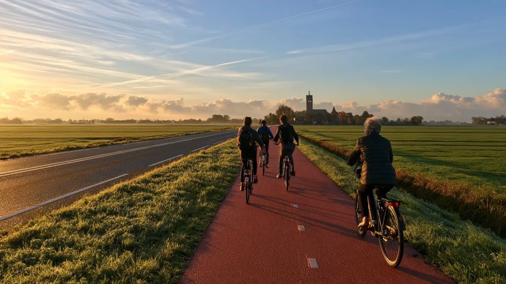
A bicycle may be a practical option for a trip that is too far to walk. The planning question is whether there is a route someone would actually use.
A corridor designed for high-speed traffic and heavy trucks needs a different assessment from a quiet neighborhood street. The fact that both appear as lines on a transportation map does not make them equivalent bicycle routes.
The plans in this series treat trails as more than recreational features. Burwell’s 2024 plan calls for a trail system connecting public facilities, parks, and schools. Kimball’s plan similarly calls for accessible bicycle and pedestrian connections to public facilities, including schools. Those are transportation objectives, even when the same facilities also support exercise and recreation.
A trail becomes transportation when it connects
A trail map should show more than the trail.
Add schools, employers, stores, housing, parks, and transit connections. Then examine entrances, crossings, surfaces, and gaps. Does the path reach the school grounds, or stop across a busy road? Does it pass behind a shopping area without an entrance? Does a bridge provide a connection, or become the point where the route fails?
Sometimes the useful project is not another mile of trail. It is the short connection that allows an existing trail to serve a daily trip.
This is also where recreation planning, transportation planning, and development review should meet. If a corridor is expected to support everyday travel, its connections and maintenance deserve attention before—not after—the adjacent property develops.
A Dutch lesson: think between places, not just within them
The Netherlands is famous for city cycling, but its regional approach is equally relevant. Dutch national policy encourages cycling routes between communities as well as within them and identifies electric bicycles as a way to make longer trips feasible. The government’s cycling-policy guidance emphasizes trips up to 15 kilometers, roughly nine miles, and the development of regional routes.
The American landscape is different. A nine-mile connection may be promising in one corridor and of little practical use in another. Right-of-way, terrain, drainage, crossings, destinations, and maintenance all belong in the assessment.
The transferable principle is not that every rural resident should bicycle everywhere. It is that planning should examine connections between nearby places rather than treating each town’s network as an island.
Could a path connect a town with a nearby school campus or employer? Could two communities share a corridor? Could an existing trail become more useful through a few carefully located links?
In another corridor, demand-response transit may be the better investment. The choice should follow actual travel needs, not a preference for one mode over another.
The Old Town Grid: Remembering What Works
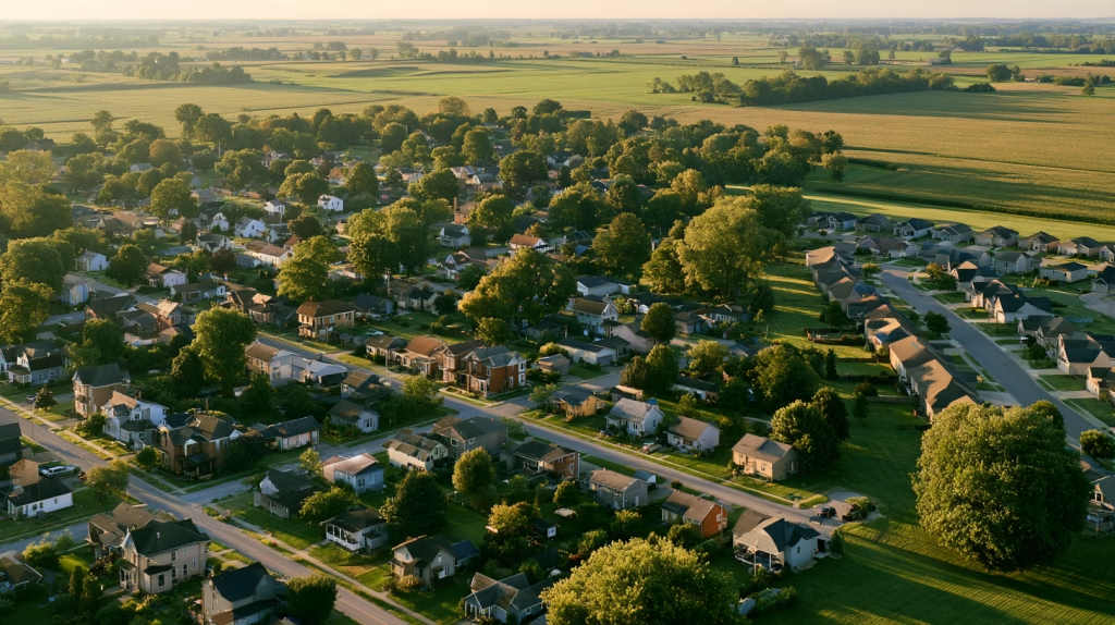
Walkability and good urban form depends on how streets, blocks, and building lots are arranged. But the traditional town grid is more than a geometry lesson. It is a record of what people learned about building places that work.
For generations, communities developed around the practical limits of everyday travel. People needed to reach work, buy groceries, send children to school, and conduct business without spending half the day getting there. Before automobiles became commonplace, walking was not an amenity to be added after development. It was a basic condition development had to accommodate. Homes, shops, workplaces, and public buildings needed useful relationships with one another because distance carried an immediate cost in time and effort.
Those relationships were refined through real-life experience. A town added a block, a builder filled a vacant lot, a merchant expanded a storefront, or a neighborhood gained another school or church. The pattern did not have to be invented from scratch with every addition. People could build on what was already there, repeat what worked, and adapt it to new needs. The result was not necessarily a single master plan carried out precisely, but a framework that many people could improve over time.
The plat might have been drawn all at once. The town was not.
That distinction matters. A grid established streets, blocks, and lots, but left room for buildings and uses to change. A neighborhood could accommodate another house, a larger business, or a different use without requiring an entirely new transportation system. Traditional development combined a relatively durable public framework with smaller, incremental private decisions. Our friends at Strong Towns describe this pattern as fine-grained development undertaken by many participants over time, rather than a place built all at once to a finished state.
We cannot preserve our old neighborhoods in amber, or assume that every inherited street is safe. A connected grid can carry unwanted through traffic, and older neighborhoods still need accessible sidewalks, usable crossings, and appropriate traffic speeds. But those shortcomings do not erase the value of the underlying network. They give us something to improve rather than something to discard.
As we discussed in last weekend’s post, streets and roads have different jobs. Streets provide access to the places along them; roads connect places over distance. The traditional town grid gives that local access a practical structure: several routes between homes, shops, schools, and public spaces, rather than one indirect way out to a collector road.
The useful inheritance is connection.
A connected neighborhood gives a person choices about how to reach a destination. It also gives the town choices about how to grow. New blocks can extend an existing pattern instead of becoming separate enclaves. A street does not have to handle every trip simply because it is the only way in or out. And a nearby destination has a better chance of being nearby in practice, not just close as the crow flies. Traditional neighborhoods possess precisely the connectedness and accessible land-use patterns that planners now seek to restore in newer development.
Alleys are part of that inheritance. Where they serve garages, deliveries, parking, and service functions, they can reduce the need for driveways across the sidewalk. Our plan for Grand Island explicitly calls for preserving alley access to reduce curb cuts. The alley may look like leftover space on a plat, but it still has a job to do. Keeping service access behind the building can help the street in front remain a place for entrances, storefronts, and people.
The more recent automobile-oriented suburban pattern changed the assumptions. Development could spread farther from existing centers because driving made those distances manageable. Residential streets increasingly became loops and cul-de-sacs feeding collectors, with traffic engineering and subdivision standards encouraging separation between local access and through movement. These arrangements offered benefits, including quieter residential streets, but they often came at the expense of direct pedestrian connections.
The problem is not that every curved street or cul-de-sac is a mistake. Nor is a rectangular grid the only way to make a walkable neighborhood. Early Radburn-style planning, for example, paired automobile cul-de-sacs with a separate pedestrian network. The more useful question is whether the development provides a direct route for someone who is not driving. A street can end for cars without becoming a dead end for everyone else.
That is where the comprehensive plan should move from appreciation of the old town to direction for the next addition.
Will the new street and pedestrian network connect with what is already there? Where a full street connection is impractical, would a pedestrian link provide a direct route to a school, park, shop, or adjacent neighborhood? Where should a future connection be reserved before another plat makes it difficult or impossible? Retrofitting those links after development can require acquiring access across private property; providing for them at the beginning is a different proposition.
The plan should also ask what surrounds the network. Connected streets are useful, but walking becomes more practical when destinations are within reach. Burwell’s 2024 comprehensive plan makes that relationship explicit, attributing its relatively favorable walkability to a compact development pattern that has kept many destinations within a 20-minute walk. The lesson is not simply to draw better streets. It is to avoid scattering the places those streets are supposed to connect.
Subdivision regulations are transportation policy, whether local officials think of them that way or not. They determine whether the next neighborhood extends the town or turns its back on it. A comprehensive plan that calls for walkability while development rules keep producing disconnected neighborhoods is working against itself.
We do not need to reproduce an old town exactly. We do need to understand why its pattern endured. Generations of residents and builders left us a framework shaped by daily use, repeated decisions, and incremental improvement. Before we replace that experience with another isolated development, we should ask what the old plat already knows.
What is your Walk Score?
Walkability has also become something we can put a number on. Walk Score, Transit Score, and Bike Score appear in real estate listings and community profiles these days, giving residents and planners a quick way to compare locations. Each uses a scale from 0 to 100, but they measure different things. They are useful indicators, not interchangeable grades for the transportation system.
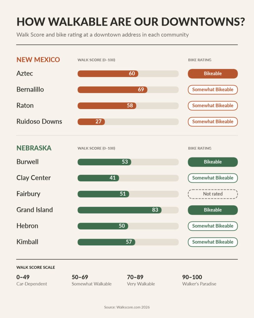
Walk Score measures access to nearby destinations, including shops, schools, parks, and other everyday amenities. Destinations within a five-minute walk receive the most credit, with points declining as distance increases. The calculation also considers street-network characteristics such as block length and intersection density. A score of 70 to 89 is labeled “Very Walkable,” meaning most errands can be accomplished on foot; 50 to 69 is “Somewhat Walkable,” meaning some errands can.
That helps explain why an older town center can perform well without having anything that looks like a modern transportation project. The destinations are already close together, and the streets provide direct connections between them. Burwell’s 2024 comprehensive plan reports a Walk Score of 59 (at that time) and credits the town’s compact pattern with keeping many destinations within a 20-minute walk. Grand Island — a larger city more spread-out, earns a Walk Score of 39 and a Bike Score of 49, though at City Hall downtown their Walk Score is an impressive 83. The state capital city of Lincoln, Nebraska, also home to the University of Nebraska’s main campus, has an average Walk Score of 44, a Transit Score of 24, and a Bike Score of 59—with Walk Score ranging from near 100 downtown and on campus to below 20 among the cul-de-sacs at the edge of town.
These metrics reflect the infrastructure each community inherited from earlier development decisions. Research by Redfin Real Estate indicate a one-point improvement in Walk Score can indicate a 1% higher average home price in a neighborhood.
But a score is not a sidewalk inspection. Walk Score’s published methods emphasize destinations, distances, and network characteristics; it does not establish whether a particular route has usable curb ramps, a comfortable highway crossing, or a sidewalk someone using a walker can negotiate. A grocery store may be close enough to contribute to the score while remaining difficult to reach in practice. The number should prompt a closer look, not substitute for one.
Transit Score measures a different kind of access. It evaluates nearby public transportation using route frequency, the type of service, and distance to stops. Its methodology relies on standardized data published by transit agencies. That makes it useful for comparing locations served by scheduled routes, but less straightforward as an assessment of rural mobility.
A county’s demand-response van may provide an essential ride without fitting neatly into a measure organized around nearby stops and scheduled service. An unavailable Transit Score should not be read as proof that no public transportation exists. Nor should a published score answer the questions that matter most to a particular passenger: Can I arrive before my shift? Am I eligible? How far ahead must I reserve? Can I get home afterward? Those require a review of the actual service, not just its proximity.
Bike Score combines four equally weighted components: bicycle infrastructure, hills, destinations and street connectivity, and the share of people commuting by bicycle. It gives separated paths more weight than bike lanes, and bike lanes more weight than shared facilities such as pavement markings.
Here, too, the number needs interpretation. Bicycle commuting is only one use of a bicycle, not a count of school trips, shopping trips, or recreational riding. And the presence of nearby infrastructure does not by itself establish that a complete route reaches the destination a resident needs. A high-scoring area still deserves a route-level review; a lower-scoring area may contain a useful connection worth strengthening.
For a comprehensive plan, the best use of these measures is to compare specific places and investigate the differences. Look at downtown, established neighborhoods, newer subdivisions, and proposed development sites. Record the location and date of each score. Then check the routes on the ground and the transit arrangements with the provider.
The planning objective is not to win a ranking. It is to understand where the town’s development pattern makes daily life easier, where the network breaks down, and what an investment or a different development decision could improve.
A score can tell us where to start looking. The walk tells us what needs fixing.
Complete Streets: Policy is Only the Beginning
Land use sets the distances. Street design decides how people can cover them.
For a small town, a Complete Streets approach should begin with the users and purpose of each corridor, not a standard package of improvements applied everywhere. It might lead to a crossing near a school, sidewalk repairs between a neighborhood and downtown, or an accessible boarding area where a transit service already stops.
It does not mean every rural highway needs the same facilities as Main Street.
The plans I’ve help write show how context changes the answer. Our 2021 plan for Aztec, New Mexico, links a proposed truck bypass with a future road diet and Complete Street on Main Avenue. Our plan for Ruidoso Downs, New Mexico, seeks pedestrian and streetscape improvements along busy US 70 while recognizing its continuing highway and freight role. The intended function of the corridor shapes the improvement.
Adopting a resolution is easier than changing the work program. Implementation touches project selection, design, budgets, maintenance, and often the relationship with the state DOT that controls the highway through town.
Every scheduled street project should therefore prompt a review of access needs early enough to influence its scope. Which identified barriers lie within the project? Which connections could be completed? What coordination is needed? What must be designed and funded before construction begins?
Kimball’s plan goes beyond a general statement of support. Action 13.1.2 commits a minimum of 5 percent of One- and Six-Year funding to multimodal improvements. That figure is a local policy, not a universal formula, and its inclusion in a plan is not proof of subsequent expenditure. But it gives decision-makers a measurable commitment to review against the annual program.
A transportation policy becomes more useful when someone can ask whether it was carried out.

What this means for your comprehensive plan
A transportation chapter in your comp plan should not start by asking which roads need widening. It should start by asking where people need to go, who has trouble getting there, and how development decisions shape those trips.
The plans in this series already point toward implementation through annual capital-program review, sidewalk and accessibility improvements, transit coordination, and connections to public facilities. The next step is to organize those actions around access rather than around separate lists of modes.
Build an access work program
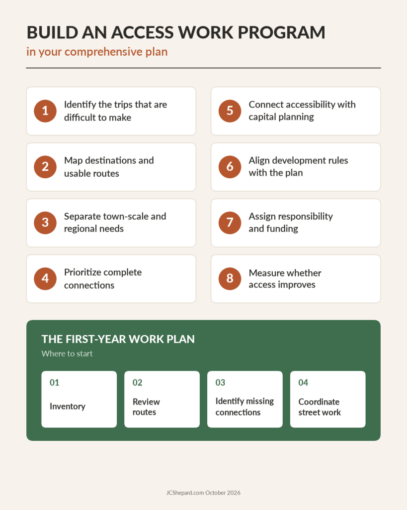
- Identify the trips that are difficult to make. Use available demographic and household information as a starting point, then talk with residents, employers, schools, transit operators, and service providers. Ask about missed trips and unsuitable schedules, not only trips already being made.
- Map destinations and usable routes. Locate schools, groceries, clinics, public offices, and employers. Examine how residents reach them, including crossings, operating hours, reservations, transfers, and the trip home.
- Separate town-scale and regional needs. A sidewalk gap downtown and a ride to a regional medical center are both access problems. They require different partners, budgets, and solutions.
- Prioritize complete connections. Evaluate a project by the route or trip it makes possible. A short missing link may be more consequential than a larger project that leaves the network disconnected.
- Connect accessibility with capital planning. Carry identified barriers into project scoping, budgets, maintenance assignments, and construction planning. Involve people who use the routes.
- Align development rules with the plan. Review street connectivity, pedestrian links, entrances, parking arrangements, and transit consultation requirements. Do not let routine approvals undo the network the plan proposes.
- Assign responsibility and funding. Identify the lead agency, partners, next decision, expected cost, and implementation window. For transit, distinguish startup costs from the continuing cost of providing rides.
- Measure whether access improves. Track not only what was built or purchased, but what became possible: a complete route to school, a workable trip to a shift, a dependable return from an appointment, or a connection that no longer requires separate arrangements.
A practical first-year program might be modest: inventory transit services, review priority pedestrian routes, identify a small set of missing connections, and coordinate them with scheduled street work. A longer-term program can then address regional service, larger crossings, trail corridors, and changes to development regulations.
The goal is not to remove the car from rural life. It is to make sure that access to work, healthcare, education, shopping, and community life does not depend entirely on owning and operating one.

In Conclusion: The Test of a Transportation System
Return to the grocery store six blocks away. The useful question is not whether the town has adopted a multimodal policy or earned a respectable Walk Score. It is whether the resident can make the trip, cross the highway, reach the entrance, and get home with the groceries. That is where the transportation chapter meets daily life.
The answer may involve repairing a sidewalk, completing a crossing, arranging a dependable ride, or keeping future housing close to existing services. It may also mean preserving an alley, reserving a connection in the next subdivision, or changing a development requirement before another barrier becomes permanent. These are different tools, but they belong to the same planning task: making the places people need available to the people who need them.
We have a useful inheritance to work with. Generations of residents and builders shaped towns through repeated use and incremental improvement, leaving networks that can still accommodate change. We need not reproduce every detail of the old town, and we should not overlook its deficiencies. We can, however, carry forward its practical lesson: put destinations within reach, connect them, and improve the connections as the community grows.
The comprehensive plan gives those intentions a place in public decision-making. Its priorities should be recognizable in the next capital budget, street project, subdivision plat, and conversation with a transit provider. A goal becomes meaningful when someone is responsible for the next step and residents can eventually use the result.
The car will remain part of small-town life. The choice before local officials is whether the town will work only for people who have one available. Those six blocks are a good place to begin—not because they settle every transportation problem, but because making one ordinary trip possible is a concrete way to build a more accessible community.
Next Sunday: Rail — freight, passengers, and the long game.
John C. Shepard, AICP, is a planner and economic development practitioner with more than thirty years in public-sector and consulting practice, and is incoming chair of the American Planning Association’s Small Town and Rural Planning Division. The views expressed here are his own.

Further Reading
Sources and background
- NDSU Upper Great Plains Transportation Institute — Rural Transit Fact Book, 2025: https://www.ugpti.org/resources/reports/details.php?id=1258
- Federal Transit Administration — Formula Grants for Rural Areas (Section 5311): https://www.transit.dot.gov/rural-formula-grants-5311
- Federal Transit Administration — CCAM Program Inventory (2025): https://www.transit.dot.gov/regulations-and-guidance/ccam/about/ccam-program-inventory
- eCFR — 28 CFR 35.150, Existing facilities (ADA Title II transition plans): https://www.ecfr.gov/current/title-28/chapter-I/part-35/subpart-D/section-35.150
- Rails to Trails Conservancy — Resource Library: https://www.railstotrails.org/resource-library/
- Cerema & ADEME — Mobility in rural and peri-urban areas (PDF in French): https://www.ort.bourgogne-franche-comte.developpement-durable.gouv.fr/IMG/pdf/plaquette_cerema_ademe_17x24_08.pdf
- Institute for Road Safety Research (SWOV) — Bicycle facilities on road segments and intersections of distributor roads (fact sheet): https://pedbikeinfo.org/resources/resources_details.cfm?id=4225
- Deutsche Bahn — Deutschland-Ticket (in German): https://regional.bahn.de/tickets/Deutschlandticket
Books
- Life After Cars: Freeing Ourselves from the Tyranny of the Automobile by Goodyear, Gordon, and Naparstek (Penguin Random House, 2025)
Written by the hosts of The War on Cars podcast, this book examines the social, environmental, and political costs of car culture and outlines practical steps like tactical urbanism and better public transit… and yes, I did say there is no war on cars, but there is a podcast by that name. - Proudly Made: A Story of Reinvention in the Big Woods and Small Towns of the Pennsylvania Wilds by Tataboline Enos (Catamount Press, 2025)
Ta Enos’ literary memoir of personal reinvention and place-based rural development, centered on the Pennsylvania Wilds movement. JCShepard.com May 2026 book of the month. - Human Transit (Revised Edition): How Clearer Thinking about Public Transit Can Enrich Our Communities and Our Lives by Jarrett Walker (Island Press, 2024)
The clearest explanation of why frequency, coverage, and connections matter more than vehicles, and a good companion to the transit section. - Confessions of A Recovering Engineer: Transportation for a Strong Town by Charles Marohn (Wiley, 2021)
Chuck Marohn delivers a vision for more accessible and engaging local transportation systems in his second book in the Strong Towns series. He delivers withering critiques of his chosen profession, yet also offers real-world examples of communities doing better for all residents. Our October 2026 featured book of the month. - Strong Towns: A Bottom-Up Revolution to Rebuild American Prosperity by Charles Marohn (Wiley, 2019)
The case for incremental, place-based development, and the land-use argument behind “the distances we create”. Our December 2025 book of the month. - Walkable City: How Downtown Can Save America, One Step at a Time by Jeff Speck (Farrar, Straus and Giroux, 2012)
A readable case for streets designed for people, and it also bridges to next week’s article. - Walkable City Rules: 101 Steps to Making Better Places by Jeff Speck (Island Press, 2018)
Practical follow-up toolkit to the bestselling Walkable City.
As an Amazon Associate, jcshepard.com earns from qualifying purchases. This does not affect the price you pay or our recommendations.
If you like books about planning and related topics, be sure to check out the Booked on Planning Podcast, a special project of the APA Nebraska Chapter with national (international!) reach. Their inaugural Virtual Book Summit takes place Monday and Tuesday this week, the 12th & 13th of October, 2026. Hope to see you (virtually) there.
Resources
Rural-Ready Engagement: Practical Tools for Small Town Planners
 Watch the full replay: youtube.com/@Engaging-Communities (February 2026). Community engagement can look very different in small towns and rural communities. This webcast was co-sponsored by the APA Community Engagement Interest Group and the Small Town & Rural Planning Division.
Dynamic Decisions Podcast (Season 2 Episode 15)
“Stop Chasing Smokestacks. Grow What You Have” with Teasha Cable of cModel Data, now playing on Youtube (audio), Apple Podcasts, Spotify (May 2026). Other listening links here.
The Rural Impact Podcast (Episode #86)
“Pathways to Powering Rural America” My guest spot on Michelle Rathman’s podcast. Episode page here, listen on Apple Podcasts or Spotify, or watch (!) on youtube. We talked about energy, data centers, and good governance, plus so much more.
Popular posts on JCShepard.com
- The Planning Process—From Vision to Action in Small Towns and Rural America (January 2026)
- Historic Preservation and Rural Economic Development: A Rural Growth Strategy (April 2026)
- Small Towns Can Build a Strong Outdoor Economy Without Selling Out (June 2026)
- The Rise of Rural Entrepreneurship: Building Economies from the Ground Up (January 2026 on Medium.com)
- When the Zoning Code Works Against the Plan (September 2026 just last month!)
- Reviving Rural America: Why Heritage Tourism Is a Game-Changer Now (September 2025)
- Main Street America and the Revival of Downtown (June 2026)
- What is Economic Development in Modern America? A Field Guide for Small Towns and Rural Places (March 2026)
- Rethinking the Rural Economy: New Paths, New Possibilities for Growth (August 2025) / Rural Entrepreneurship: Building Economies from the Ground Up (August 2026 on Medium.com)
- How Small Towns Succeed: A Proven Playbook for Rural Action (November 2025)
- Is Rural Really the Same as Non-Metro? (February 2026)
- Revitalizing Main Street the Idea-Friendly Way (August 2026 on Medium.com)
- Small Towns, Big Impact: How Rural Communities Are Designing Their Own Futures (November 2026)
- Floodplain Management and the Comprehensive Plan: Beyond the FEMA Flood Map (August 2026)
- Stop Chasing Smokestacks: A Practical Guide to Small‑Town Economic Development (May 2026)
Check out The 12 Planning & Sustainability Books You Need in 2026 and browse through the Small Town & Rural Community guides on our Resources page.
.