

Reconnecting Land Use and Community Health
Growth that ignores how people live is just sprawl with better marketing.
This week, we look at how sustainability and Smart Growth principles, local food systems, and land conservation fit together as one interconnected strategy for rural communities that want growth to work for them rather than against them.
We have done a really good job over the last century of building places we now regret. Where we thought we saw the way of progress, the wave of the future zooming by in the automobile, we build the suburban experiment. And we quietly hollowed out our middle. When we put convenience over experience, the hardware store becomes a dollar store, the hometown diner closes and nothing replaces it, the elementary school sits miles from the nearest cluster of houses and nobody walks anywhere anymore.
We talk about this in big cities. We are beginning to talk about this in the rings of suburbia. Yet most people who grow up in rural America know this feeling without having words for it. What they are describing, without knowing it, is a land use problem. Sustainability in this context means land use patterns that hold over generations: compact towns that cost less to serve, farmland that stays in production, and local food systems that can ride out shocks.
Two Towns
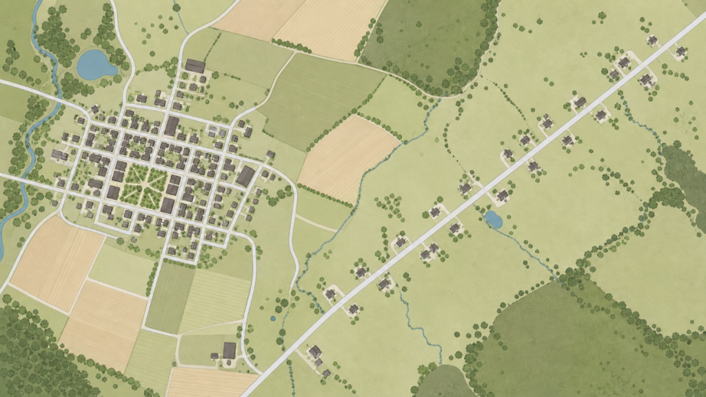
Picture two small towns, forty miles apart, both growing. In the first, a new subdivision sprouts along a county road three miles from the nearest school. The lots are large, the driveways long, and the nearest grocery store is a twenty-minute drive. Nobody planned for a sidewalk because there was nowhere obvious to walk to. The town gets bigger, but not better — and a decade later, the water and sewer extensions that made it possible are costing the county more to maintain than they generate in tax base. That pattern may feel like growth in the short term, but it is not sustainable—fiscally, environmentally, or socially—when infrastructure costs outrun the tax base and every basic need requires a car trip.
In the second town, the planning commission dedicated a full year composing their comprehensive plan. They identified an underutilized block near downtown as a priority infill site. A local developer built a modest mixed-use project — eight units above a small commercial space, served by the existing water main and within four blocks of the elementary school. A farmers market launched in the adjacent parking lot. The town grew, too. But it grew in a way that reinforced what was already there. By growing on existing water and sewer lines, within walking distance of the school, this town chose a more sustainable pattern: one that uses less land and fuel per household and costs less to maintain over time.
Both outcomes were choices. And they were planning choices, made years before the first shovel broke ground.

The Problem With the Pattern We’ve Built
Rural sprawl does not look like urban sprawl, but it produces many of the same outcomes: longer distances between people and services, higher per-capita infrastructure costs, degraded natural lands, and built environments that make daily life harder for anyone who cannot drive.
The pattern is familiar across rural America. Residential development migrates outward along arterials and township roads, drawn by cheap land and few regulatory barriers. Town centers lose the density that once made them commercially viable. Historic downtowns hollow out. The remaining residents drive farther for basics. And local governments inherit infrastructure networks — roads, water lines, emergency services — that are expensive to serve and politically difficult to rationalize.
Core Principles
The American Planning Association developed the APA Policy Guide on Smart Growth in 2002, with an update in 2012. The guide identifies Smart Growth as policies supporting choices and opportunity in how people live, work, and play. “This approach to growth and planning can not only deliver dynamic attractive communities with greater choices for consumers but can be a powerful tool for farmland, open space and habitat preservation.” The Policy Guide discusses economic benefits, inclusive planning process, transportation and land development, fiscal efficiency, social equity and community building, farmland protection and land conservation, and healthy communities.
For rural communities, sustainability is not a slogan; it is about patterns of growth that a county can afford to maintain, that keep farms and main streets viable, and that do not burn through land, water, and fuel faster than we can replace them.
In Hall County, Nebraska, the comprehensive plan (which I worked on with Marvin Planning Consultants) addresses this directly. Among its goals: directing new development to existing communities and established service areas, and supporting land use patterns that reduce vehicle miles traveled while increasing access to daily needs on foot or by bicycle. These are not aesthetic preferences. They reflect a clear-eyed accounting of what dispersed development actually costs — fiscally, environmentally, and in terms of community health.
Our comp plan with Jefferson County, Nebraska, takes a similar position on agricultural land protection, recognizing that once productive farmland is converted to low-density residential use, it rarely returns. Agricultural land generates tax revenue with relatively low service demands. A rural subdivision inverts that relationship — lower density, higher service cost, and less productive land.
The core insight of Smart Growth is not that rural communities should stop growing. It is that where and how growth happens determines whether it strengthens or weakens the community over time.
Smart Growth in Rural Communities: What It Actually Looks Like
Smart Growth is a framework, not a blueprint. The EPA’s Office of Sustainable Communities long maintained principles — compact development, mixed uses, walkable streets, a range of housing choices, and preservation of open space — that were originally developed in response to suburban sprawl but translate well, with adaptation, to rural and small-town contexts. (EPA’s Smart Growth activities are now led by the EPA Office of Community Revitalization.)
In rural communities, Smart Growth does not mean building like a city. It means building like a small town used to build — with streets that connect, buildings that front the sidewalk, and uses that reinforce each other rather than requiring a car trip between every destination. A few practical applications worth highlighting:
Infill and Redevelopment First
Before extending services to a new greenfield subdivision, most Smart Growth-aligned plans ask: is there a site within the existing service area where this development could go instead? A plan that establishes infill priority — and backs it up with streamlined permitting, reduced setbacks for urban-scale lots, and zoning that allows by-right development in designated areas — gives the market a clear signal.
Downtown as the Center of Growth Strategy
Rural Main Streets are not just economic assets; they are health assets. A walkable downtown with a grocery store, a clinic, a coffee shop, and a few upper-floor apartments is a community health intervention in land use form. Hall County’s plan references mixed-use development in downtown Grand Island as a deliberate strategy for supporting walking and reducing car dependency for daily trips.
Housing Diversity Within Town Boundaries
One of the quieter consequences of rural sprawl is that it tends to produce only one housing type: single-family detached, on a large lot, accessible only by car. Diversifying the housing stock within existing town boundaries — through accessory dwelling units, small-lot single-family development, and modest multifamily — expands who can live close to services and reduces pressure for greenfield expansion.
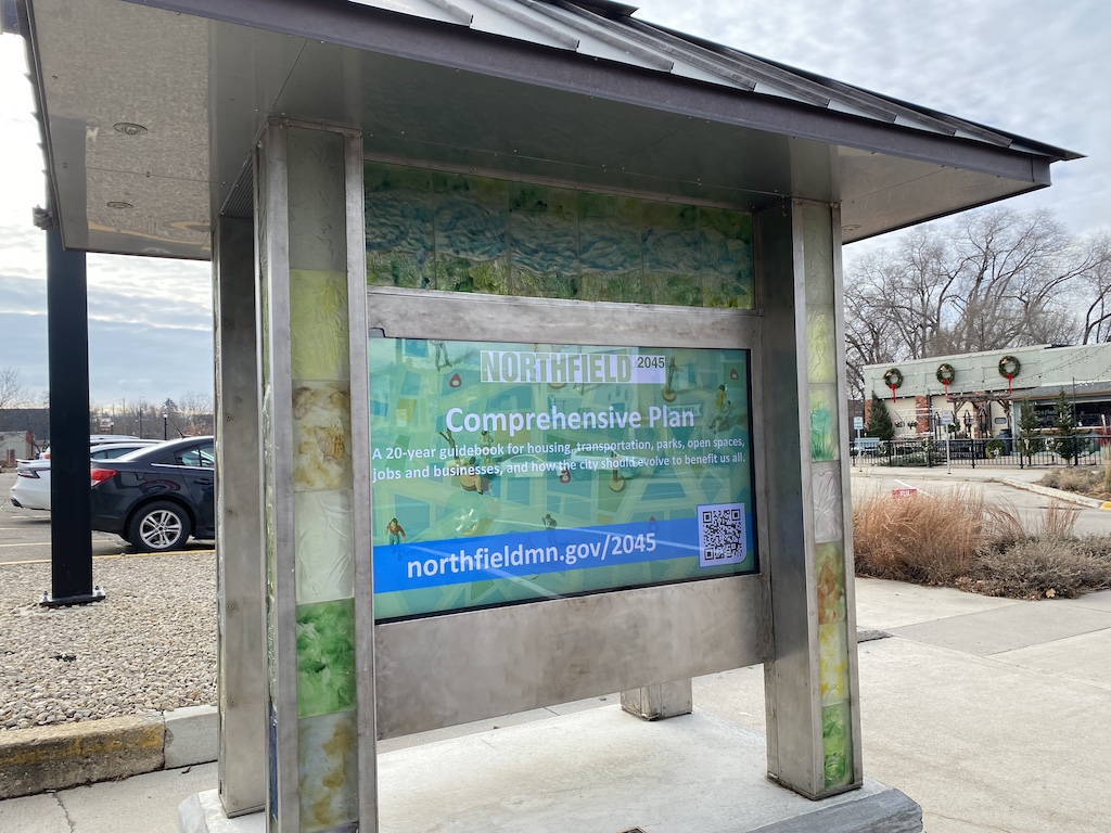
Northfield, Minnesota — Compact Growth and a Working Downtown
Rice County, Minnesota · Population ~21,000 · River town with college anchor
The City of Northfield has spent twenty years using Smart Growth principles to manage development pressure from the Twin Cities corridor without surrendering the small-town character that makes it distinctive. The city’s comprehensive plan established a clear urban growth boundary, directing new residential development into contiguous areas served by existing infrastructure rather than leap-frogging into agricultural land on the fringe.
Northfield is the kind of town that knows what it is. It is a town with two colleges more than a “college town”. It is attractive to people from the Urban Twin Cities, suburban Metro communities, and small town rural Minnesota.
Downtown has a Main Street that functions as one, a river that people actually walk to, a downtown that draws people on a Saturday morning not because there is nowhere else to go but because it is genuinely worth going to. That character did not survive twenty years of development pressure by accident. It survived because someone wrote it into a plan, and then held the line.
Downtown Northfield — centered on a National Historic District along the Cannon River — has benefited directly. A sustained policy of upper-floor housing above commercial space, combined with streetscape investment and a shared-use parking strategy, added over 60 housing units within walking distance of the downtown core between 2010 and 2022. The farmers market relocated to a permanent downtown site and now anchors a Saturday morning economy that draws from a twenty-mile radius.
The City tracks cost-of-service ratios by development type. Their analysis consistently shows that compact, infill residential development within the existing service boundary costs 40–60% less to serve annually than equivalent units at the urban fringe — a figure that has become a standard part of presentations to developers and elected officials.
Northfield recently adopted a new comprehensive plan, with a community-driven public process. Plan elements focus on Access (connecting people to places and opportunities), a Sustainable Economic Future (connecting housing and economic security), Resilient Infrastructure (connecting essential municipal services with sustainability) and Implementation. The work continues.
Tracking cost-of-service ratios by development type gives planners and elected officials a fiscal argument for compact growth that is often more persuasive than environmental or health framing alone — and it removes the perception that Smart Growth is simply an aesthetic preference.

Local Food Systems as a Smart Growth Strategy
It is tempting to treat local food as a separate topic from land use planning. It should not be. When a rural community has a functioning local food economy — farmers markets, community gardens, cottage food enterprises, food hubs, and farm-to-institution programs — it reduces food desert conditions within town, keeps dollars circulating locally, and creates economic opportunity for producers who might otherwise struggle to remain viable at small scale.
A functioning local food economy—farmers markets, CSAs, cottage foods, food hubs, and farm‑to‑institution programs—makes a town’s food supply more sustainable by shortening supply chains, cutting transport emissions, and giving small producers enough margin to stay on the land.
Hall County’s comprehensive plan makes this connection explicit, treating local food infrastructure as both a health goal and an economic development strategy. A farmers market is not just a pleasant amenity. It is a weekly gathering that generates foot traffic for adjacent businesses, shortens the supply chain between producer and consumer, and reduces the distance residents must travel for fresh produce.
Thayer County’s agricultural economy — like many rural Nebraska counties — is deeply tied to commodity production at scale. But the planning opportunity lies in the margins: cottage food production enabled by a simple zoning permission; a community garden on an underused municipal parcel; a local school lunch program that sources from a nearby farm. These are not transformational by themselves. But they are pieces of a food system that, over time, adds up to something more resilient than total dependence on distant supply chains.
- Cottage Food Permissions — Streamlining home-based food production removes a significant barrier for small producers at near-zero cost to the county
- Farmers Market Zoning — Designating a downtown site or fairgrounds lot with a simple permit process removes uncertainty for organizers and creates a predictable location for buyers
- Community Garden Policy — A water hookup, a simple lease, and a local organization to manage the site. Low capital investment, real and well-documented health returns
- Farm-to-Institution Connections — Schools, hospitals, and county facilities are among the largest food buyers in rural communities; explicit local procurement goals create a market signal for producers
- Food Hub Development — Aggregation infrastructure that allows small producers to reach institutional buyers and grocery accounts at viable volume
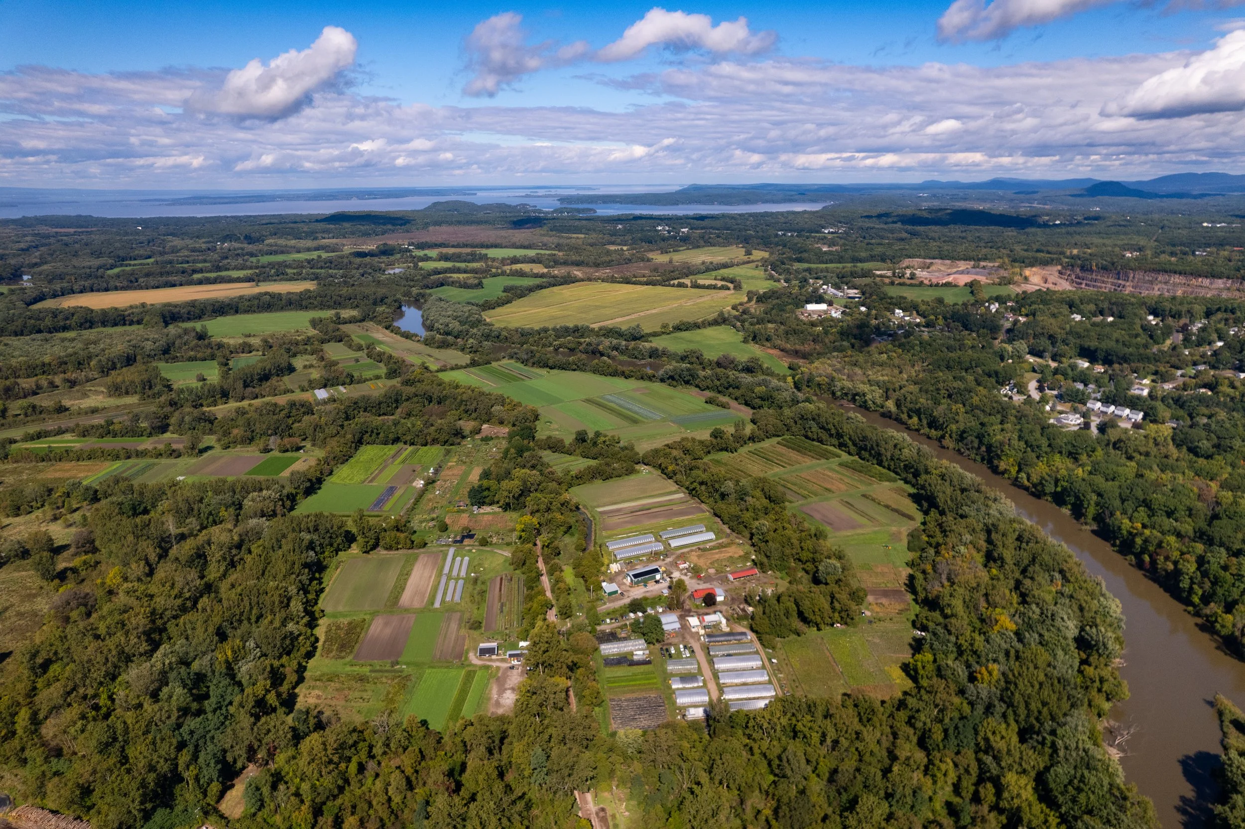
Intervale Center — Burlington, Vermont
Chittenden County, Vermont · Intervale floodplain, City of Burlington
The Intervale is one of the most studied examples of urban-edge agricultural land conservation and local food system development in the country — and it is directly relevant to rural planners because the mechanism is replicable at county scale. Burlington is a small city that has never quite forgotten it sits in a river valley surrounded by farmland. The Intervale — a stretch of floodplain ten minutes from downtown — is the reason that memory has staying power. In the late 1980s, Burlington’s city government worked with community advocates to prevent a 350-acre floodplain from being developed into a wastewater facility, instead establishing it as protected agricultural land managed by a nonprofit land trust.
Today, the Intervale hosts 14 independent farm operations producing over 500,000 pounds of food annually, with the majority sold into local markets within 50 miles. A shared-infrastructure model — common cold storage, equipment, and processing space — reduces the capital barrier for beginning farmers, who lease land at below-market rates in exchange for local market commitments. The center also operates a community supported agriculture (CSA) program serving approximately 900 households. By conserving floodplain adjacent to town for agriculture, Burlington turned land that might have been paved over into sustainable food infrastructure: 500,000 pounds of food grown close to where people live, on land that also stores floodwaters.
The planning lesson is not that every rural county needs a formal land trust or nonprofit manager. It is that agricultural land adjacent to town centers can serve double duty — conservation and local food production — when planning intentionally creates the conditions for both. A simple agricultural zoning designation and a community garden lease cost almost nothing; a managed land trust at scale costs more but can be built incrementally.
Protecting agricultural land adjacent to town centers is not just a conservation act — it is local food system infrastructure. Shared-resource models that reduce capital barriers for beginning farmers are replicable at rural county scale, often through existing conservation or extension channels.

Land Conservation as Infrastructure
Conservation easements, agricultural zoning, and open space preservation are often treated as environmental programs; in reality they are core sustainability tools. They protect the working land base that rural economies, food systems, and water quality depend on.
A conservation easement on a working farm at the edge of town does several things at once: it keeps that land in agricultural production, maintains a tax base with low service demands, prevents the extension of costly infrastructure into low-density residential development, and preserves the rural character that attracts people to these communities in the first place. In counties where agricultural identity is central to economic development strategy — heritage tourism, agritourism, food systems — that character is not sentiment. It is a competitive asset.
Jefferson County’s comprehensive plan addresses this directly, calling for the protection of agricultural land and the prevention of premature conversion to non-agricultural uses. Thayer County’s plan similarly emphasizes supporting the agricultural economy as a foundation of community health. These commitments, to be meaningful, need to be translated into specific land use policies: agricultural zoning with meaningful minimum lot sizes, transfer of development rights programs where feasible, and targeted acquisition of easements on the most productive or environmentally sensitive parcels.
A community that protects its agricultural land on the periphery has a stronger rationale for directing growth inward. The two strategies reinforce each other — or undermine each other.
Conservation also connects directly to public health. Access to natural areas, working landscapes, and open space is associated with reduced stress, increased physical activity, and stronger community attachment. Thayer County’s plan identifies outdoor recreation as a component of quality of life and community health — a conservation argument as much as a recreation argument. The open lands have to be there first.
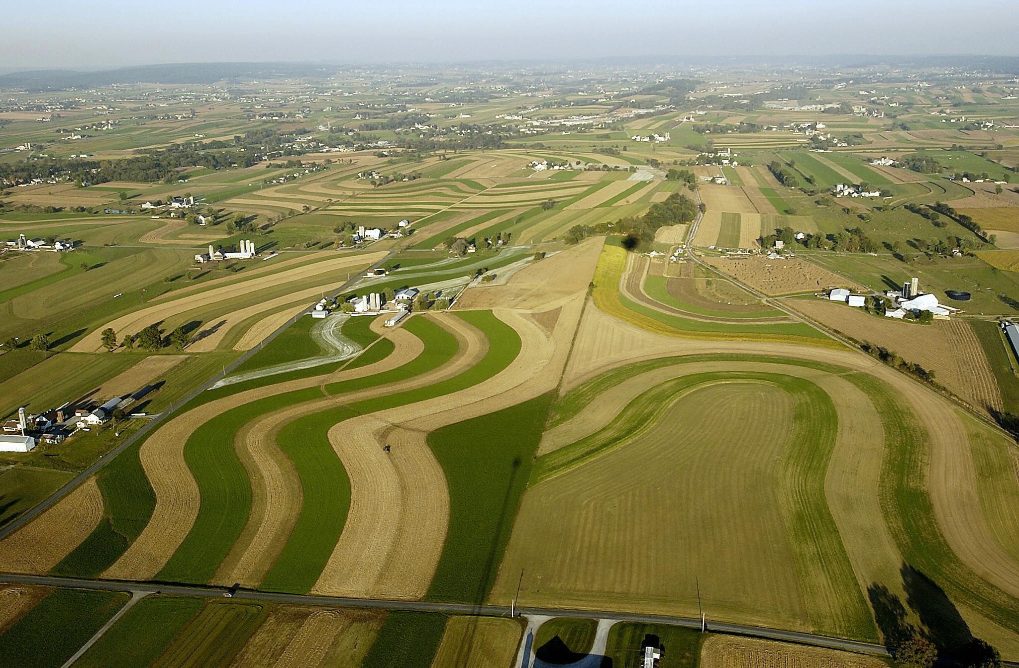
Lancaster County, Pennsylvania — Farmland Preservation at County Scale
Lancaster County, Pennsylvania · Population ~550,000 · Nation’s most productive non-irrigated agricultural county
Lancaster County operates what is widely regarded as the most successful county-level farmland preservation program in the United States. Lancaster County is Amish country, yes — but it is also one of the most contested agricultural landscapes in the eastern United States, caught between some of the most productive non-irrigated farmland in the country and one of the most relentless development corridors on the East Coast. The preservation program was not born of sentiment. It was born of urgency. Facing intense development pressure from Philadelphia and the I-95 corridor since the 1970s, the county established a dedicated Agricultural Preserve Board in 1980 with authority to purchase agricultural conservation easements on a voluntary basis from willing landowners.
The program has since preserved over 100,000 acres across more than 1,400 farms — permanently removing that land from development while keeping it in private agricultural ownership and production. Funding comes from a combination of county bond authority, state Agricultural Conservation Easement Program (ACEP) matching funds, and municipal contributions. An independent economic analysis found that every dollar invested in farmland preservation generates approximately $3 in avoided infrastructure costs — roads, water lines, emergency services — that would have been required if that land had developed at residential densities. That is sustainability in numbers: every dollar spent to keep farmland in production prevents three dollars of new pipe, pavement, and emergency service coverage
For rural planners in smaller counties, Lancaster’s scale is not the lesson — the mechanism is. A modest easement fund of $500,000, matched with state ACEP and USDA RCPP funds, can protect several farms per year in a county where land values are lower. The political case is easier to make when the fiscal return is documented and local.
Farmland preservation generates a documented fiscal return through avoided infrastructure costs — an argument that works across political lines. State and federal matching programs (ACEP, RCPP) make county-level programs viable at modest investment levels; the mechanism scales down to smaller rural counties when land values allow.

Integrating the Three Strategies
A comprehensive plan that treats Smart Growth, local food, and land conservation as separate elements — rather than as components of a single resilience strategy — will produce siloed implementation. The most effective plans make the connections explicit: land conservation protects the agricultural base that supports local food systems; local food systems give economic value to working landscapes that makes conservation more viable; compact development reduces pressure on those landscapes and strengthens the town centers where markets, gardens, and local enterprise can thrive.
Patterns that reduce vehicle miles traveled and increase access to daily needs on foot or by bicycle are sustainability strategies as much as health strategies; they lock in lower emissions and lower long‑term infrastructure costs. Traditional main‑street patterns—with trees, shade, and buildings close to the sidewalk—also create microclimates that are safer and more comfortable in summer than wide, treeless arterials, a small but real part of climate resilience. An infrastructure policy that favors maintenance and reinvestment over endless extensions is a sustainability policy: it limits the miles of pipe and pavement the county must support, it preserves groundwater and septic capacity, and it keeps existing neighborhoods viable.
The recent Nebraska county plans we’ve looked at today — Hall, Jefferson, and Thayer — each approach this differently, shaped by local conditions. In Hall County’s plan we made the most of connecting food access, health outcomes, and economic development in the same policy framework. Jefferson County leans hardest on agricultural land protection as an economic foundation. In Thayer County’s plan, we emphasized the connection between natural landscapes, outdoor recreation, and quality of life. Together, they illustrate how the same underlying logic plays out differently depending on what a county already has and what it most needs to protect.
When small town planners talk about sustainability in rural communities, this is what we mean: conserving working landscapes, growing compact towns we can afford to maintain, and building local food and transportation systems that don’t fall apart when fuel prices spike or supply chains break. Smart Growth, land conservation, and local food policy are three faces of that same long‑term stewardship.
- Write growth boundaries into the plan — Not as hard regulatory lines, but as preferred development areas reflecting existing infrastructure; make the fiscal case for requiring full cost recovery on extensions beyond them
- Connect food policy to land use language — A single paragraph in the economic development or health chapter provides the policy basis for later action on markets, gardens, and cottage food
- Protect agricultural land through zoning, not just aspiration — Minimum agricultural lot sizes, limitations on non-farm residential uses, and a clear policy against piecemeal rezoning are the tools that actually slow conversion
- Make compact development the easier path — Reduce regulatory friction for infill: streamlined permitting, reduced setbacks, by-right approval for appropriately scaled projects in designated areas
- Pursue agricultural conservation easements strategically — State ACEP and USDA RCPP matching funds make county-level programs viable; prioritize the most productive parcels adjacent to existing town centers
- Document the fiscal case — Cost-of-service comparisons, avoided infrastructure cost calculations, and local economic multiplier data are more persuasive with elected officials than environmental framing alone

Looking Ahead
Week 4 arrives just in time for Memorial Day weekend — which is not a coincidence. Outdoor recreation is the thread that connects the conservation landscape to the local economy, and it is one of the fastest-growing rural economic sectors in the country. Next week: trails, campgrounds, wildlife areas, and county fairgrounds as economic infrastructure, and the planning frameworks that help communities make the most of what they already have.
Most rural communities don’t have a growth problem. They have a pattern problem. The land exists. The farmland exists. The downtown exists. What’s missing is the planning framework that treats them as a system — not as separate issues competing for the same limited budget. The places worth saving already exist. The question is whether the plan reflects that.
Pull up your county’s comprehensive plan and search for the word “food.” If it doesn’t appear in your land use or economic development chapter, that’s your starting point — one paragraph of explicit policy language opens the door to everything else.
- Week 1 — Public health and livability: tools, data, and what local government can do
- Week 2 — Bringing Parks and Recreation into the Community Plan
- Week 3 — Sustainability and Smart Growth: land conservation, local food, and compact development (this article)
- Week 4 — Outdoor recreation (Memorial Day): economic development, identity, and health
- Week 5 — A county-level playbook: synthesizing five weeks into Monday morning actions
Smart Growth America is a national nonprofit that connects the dots across sectors—housing, transportation, climate, equity, and governance—while translating them into a practical, bipartisan, and results-oriented agenda. We provide community leaders, advocates, and philanthropy with proven strategies, trusted analysis, peer networks, and clear pathways to lasting change.
Primary landing page for Smart Growth resources, including key topics, technical assistance, tools and resources.
Landing page for rural Smart Growth resources, including the Putting Smart Growth to Work in Rural Communities guide co-published with ICMA. Case studies and technical assistance examples scaled to smaller jurisdictions.
NAR’s Smart Growth program has resources to help local real estate professionals including smart growth grants, placemaking grants, issue research and assistance, publications, plus polling and surveys.
State-by-state data on agricultural land conversion rates, conservation easement program information, and policy tools for agricultural land protection. Their national reports quantify conversion in ways useful for public communication.
Federal matching funds for agricultural land easements, administered through NRCS. Essential when advising local landowners or working with conservation partners; state offices administer local application cycles and eligibility.
Local Food Directories, market data, and technical assistance for communities building local food infrastructure. Includes guidance on farmers market development, food hub feasibility, and farm-to-institution programs.
Marohn’s case for incremental, fiscally sound development is required reading for anyone making the political argument for compact growth in small towns. The fiscal analysis tools — comparing the cost of development patterns — are directly applicable to rural planning.
Supports local and regional land trusts with resources on conservation easements, agricultural land protection, and community conservation planning. Useful for connecting rural counties with existing land trust partners in their region.
An informal coalition of organizations and individuals who seek to promote the Smart Growth approach in the United Kingdom, as a sustainable approach to planning that emphasises compact and accessible urban communities and which opposes urban sprawl and car dependency.
The most practical single resource on rural Smart Growth implementation. Covers infill, agricultural land protection, downtown revitalization, and natural resource stewardship with rural-specific case studies throughout.
What is smart growth? the authors of the book Suburban Nation present ideas on new urbanism, green design, and healthy communities in a comprehensive, illustrated handbook.
This academic treatment, as Planetizen’s book review tells us, combines issues associated with smart growth (zoning, transit, street design) with traditional environmental issues (stormwater runoff, wildlife preservation, etc).
Not a rural planning book per se — but the most persuasive case for incremental, fiscally sound development available. Marohn’s argument that small investments in the built environment compound over time maps directly onto the Smart Growth framework in this article.
More from JCShepard(dot)com
Related posts:
- November 2025: Wins for Active Living: Simple Infrastructure to Unlock Rural Health
- July 2025: The New Rural Playbook: Planning Trends That Matter
- April 2025: From Vision to Reality: Why Good Planning Powers Good Governance
Our April 2026 series on Community Facilities:
- Rural Civic Infrastructure Is Driving a New Future for Small Town Communities
- Historic Preservation and Rural Economic Development: A Rural Growth Strategy
- Good Governance and Trust in Rural America
- How Education as Infrastructure Is Powering Rural Economic Growth
2026: Bring Your Plans to Life – Monthly Themes Preview
RuralStrong Podcast (Season 1 Episode 36)
Now playing on Youtube (audio), Spotify, and Apple Podcasts (February 2026). Transcription on the blog here.
Rural-Ready Engagement: Practical Tools for Small Town Planners
 Watch the full replay: youtube.com/@Engaging-Communities (February 2026)
Community engagement can look very different in small towns and rural communities. This webcast was co-sponsored by the APA Community Engagement Interest Group and the Small Town & Rural Planning Division.
Popular posts on JCShepard.com
- The Planning Process—From Vision to Action in Small Towns and Rural America (January 2026)
- Reviving Rural America: Why Heritage Tourism Is a Game-Changer Now (September 2025)
- What is Economic Development in Modern America? A Field Guide for Small Towns and Rural Places (March 2026)
- Rural Housing Supply Crisis: Why Small Towns Are Running Out of Homes (February 2026)
- How Small Towns Succeed: A Proven Playbook for Rural Action (November 2025)
- The Rural Comeback: How Small Town Innovation Sparks Growth (August 2025)
- How Small Towns Can Build a Strong Outdoor Economy Without Selling Out (June 2025)
Check out The 12 Planning & Sustainability Books You Need in 2026 and browse through the Small Town & Rural Community guides on our Resources page.
(As an Amazon Associate, we may earn commissions from qualifying purchases. Check your local library or bookshop, too.)

1 Comment
I wanted to clarify this statistic: “An independent economic analysis found that every dollar invested in farmland preservation generates approximately $3 in avoided infrastructure costs…” This restates the statistic agricultural land typically only requires 36 cents in infrastructure and services for every $1 in taxes, referring back to general Costs of Community Services studies, as summarized in particular:
Kotchen, M. J., & Schulte, S. L. (2009). A meta-analysis of cost of community service studies. International Regional Science Review, 32(3), 376–399. https://doi.org/10.1177/0160017609336082
I need to find a more up to date source, hopefully not hidden behind an academic paywall–let me know if you know of one.