
How Small Towns Can Plan for People, Land, and Legacy
This article continues our November series: From Ideas to Action — A Month of Praxis and Implementation in Rural Communities.
In week three, we focus on turning planning theories into useful rural zoning strategies — the essential tools that help small towns manage growth, protect open land, and stay true to their character. In practice, land use planning for small towns means more than zoning maps and ordinances; it’s about practical, place-based decisions made by neighbors, planning boards, and elected officials. These decisions shape how and where to build, what to preserve, and how to ensure development aligns with community identity.
Across the country, rural communities are turning ideas into action through smart rural land use implementation. Whether it’s protecting farmland through conservation subdivisions, revitalizing Main Street with flexible mixed-use codes, or using cluster housing in rural areas to guide compact growth, the focus is on solutions that fit both people and place.
When done well, zoning in rural America is less about regulation and more about stewardship. The best land use codes emerge from local conversation, not outside templates. They preserve what matters—working lands, walkable communities, and rural legacies—while allowing room for change that serves the whole.
Zoning, in this context, is not just about drawing lines on a map—it’s about making choices. How do we grow without giving up what grounds us? How do we plan not just for buildings, but for belonging? These aren’t theoretical questions. They are the heart of rural planning—and their answers lie in thoughtful, grounded implementation.

Praxis at Work: Rural Zoning Strategies in Action
Theory is important—but it’s implementation that shapes the towns we live in. For rural communities, the effectiveness of zoning isn’t measured by how well it matches national templates, but by how well it supports the land, the people, and the long-term goals of the place.
That’s the essence of praxis: turning planning concepts into real-world decisions through ordinances, site design, and public engagement. It might mean updating outdated code. It might mean piloting cluster housing in rural areas to preserve farmland. But in every case, it’s about finding rural zoning strategies that serve both community needs and the land itself.
These efforts are especially critical when it comes to land use planning for small towns, where resources are limited and every planning decision has long-term impact. When communities take ownership of zoning, they can implement smart, flexible solutions—from conservation subdivisions to form-based codes—that balance growth with preservation.
The case studies below offer tangible examples of rural land use implementation in action. These aren’t abstract ideas—they’re real projects and policies that show what’s possible when zoning is grounded in local values, practical tools, and a deep respect for place.

Compact Development Protects Farmland in Vermont: How Hinesburg Enables Growth Without Sprawl
Compact development patterns are grounded in planning theories such as Smart Growth and sustainable urbanism, which advocate for denser, mixed-use community layouts that concentrate growth within established town or village boundaries instead of scattered, low-density expansion. Believe it or not, there is no place more “urban” than a traditional small town!
The core premise of these planning theories is that compact development preserves rural landscapes and open spaces, reduces infrastructure costs, fosters community engagement, and supports local economies.
Why Vermont?
Vermont’s landscape and economy revolve around working lands—family farms, maple groves, and open fields. Yet like many rural states, it faces mounting development pressure. Without intervention, traditional subdivisions and scattered growth could fragment farmland and disrupt the fabric of small-town life.
To counter this, towns like Hinesburg, located south of the state’s largest city of Burlington, have embraced cluster housing through forward-thinking zoning ordinances. These type of conservation subdivisions allow homes to be built on smaller lots in designated areas while protecting surrounding acreage for farming or open space—often through permanent easements.
Vermont state law encourages municipalities to use planned unit development (PUD) regulations to enable cluster development and provide flexibility in zoning. This approach not only curbs sprawl and reduces infrastructure costs, but it also supports Vermont’s long-standing commitment to compact, walkable communities with a strong sense of place. It’s a clear example of how rural zoning strategies can serve both people and the land.
Goals and Benefits
Communities in Vermont are encouraging rural cluster development to:
- Preserve agricultural and forest lands by discouraging their conversion to house lots.
- Maintain open space and the integrity of natural landscapes and wildlife corridors.
- Streamline local permitting processes and making growth predictable for applicants.
- Support affordability and sustainability of rural communities, including through infrastructure and housing support.
Implementation Strategies
Common strategies and tools in Vermont for rural cluster development have included:
- Clustered Subdivisions: Houses are built close together on a part of a parcel, leaving large portions undeveloped.
- Density-Based Zoning: Allows for smaller lots grouped together, keeping overall development density low to minimize land fragmentation.
- Planned Unit Developments (PUDs): Municipalities can provide for PUD development, which provide flexibility in lot layout, building placement, and clustering, compatible with rural character.
- Village and Hamlet Centers: Growth is focused in or near designated village centers and hamlets, supporting walkability and mixed uses, with connections to support services.
Disclosure: I have not yet had a chance to visit the Green Mountain State, although my ancestors were early pioneers there. So these are observations from a distance.
Village Growth Area, Hinesburg
Background
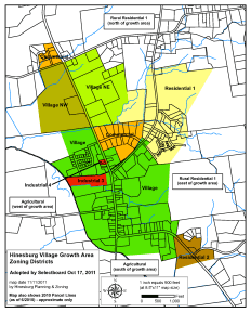
Hinesburg, Vermont, is a town of about 4,700 residents in Chittendon County, Vermont. The Village Growth Area (VGA) is the town’s central planning district, designed to concentrate future growth in an area with existing infrastructure, walkable streets, and proximity to essential services. Created in 2015 through major zoning revisions, the VGA covers eight subdistricts that collectively form the heart of the Hinesburg village.
Features and Vision
- The VGA enables higher-density residential and mixed-use development, supporting smart growth principles while conserving open space.
- Development is clustered near the village center, making efficient use of water, sewer, roads, and community infrastructure, and reducing sprawl in rural surroundings.
- The district promotes walkability, improved bike and pedestrian connectivity, and access to shops, schools, and public amenities.
- Open space, stream buffers, and greenways are required elements in all large new developments, enhancing conservation and environmental protection.
Zoning and Development Standards
- Densities range from 2 to 4 dwelling units per acre, with the highest concentrations closest to Main Street.
- Inclusionary zoning requirements in the VGA mandate affordable housing set-asides for larger projects, ensuring economic diversity while facilitating more homes.
- Density bonuses are available for developments emphasizing green building, small dwelling units, renewable energy adoption, or expanded public amenities.
- Development review encourages clustering of homes and businesses, maintaining large swaths of land in open or natural form.
Impact and Implementation
- Since adoption, the VGA has guided most new development in Hinesburg, from housing subdivisions to new retail, school, and recreation facilities.
- The VGA has become a model for Vermont towns aiming to grow without sacrificing rural character, making the village the hub of commerce, culture, and daily life.
The Village Growth Area in Hinesburg is an example of Vermont’s contemporary zoning for sustainable village-centered growth, enhancing livability, affordability, and environmental stewardship in the region.
Outcomes
- Farmland and Open Space Protected:
- 40% of the VGA’s total area (200+ acres) is permanently protected as farmland or forest (Chittenden County Regional Planning Commission, 2023).
- Three new farms established on protected land, supported by USDA Beginning Farmer grants.
- Efficient Infrastructure:
- 35% lower per-unit infrastructure costs compared to sprawling subdivisions (Headwaters Economics, 2022).
- Shared stormwater systems and solar microgrids reduced long-term maintenance costs.
- Housing and Economic Diversity:
- 20% of new units are affordable, funded through VHCB and state housing programs.
- Local businesses thrived: A new village market, brewery, and daycare opened due to increased foot traffic.
- Community Buy-In:
- 80% of residents surveyed in 2023 supported the VGA model, citing preserved rural views and stronger community ties (Hinesburg Planning Commission).
Lessons Learned
- Phased Growth Reduces Risk:
- Hinesburg staggered development over 10 years, allowing time to adjust infrastructure and monitor impacts.
- Design Matters:
- Requiring traditional New England architecture (gable roofs, clapboard siding) helped new development blend seamlessly with the existing village.
- Partnerships Are Key:
- Collaborations with VHCB, USDA, and local land trusts provided funding for easements and affordable housing.
Key Takeaways and Advice for Planners
1. Start with a Shared Vision
- Hold a community charrette or workshop to map out what residents want to protect (e.g., farmland, views, historic buildings) and where growth could go.
- Tip: Use large-scale maps and sticky notes to let people visually mark priorities.
2. Design for the Land (Not Against It)
- Work with farmers and conservationists to identify where clustering makes sense and what land should be protected.
- Allow flexibility and mixed-use to provide options for land owners and residents.
- Example: Hinesburg’s VGA was sited near existing water/sewer lines to minimize infrastructure costs.
- Avoid placing clusters in floodplains, prime farmland, or ecologically sensitive areas.
3. Use Visuals to Build Support
- Create before/after renderings of how cluster housing will look. Middlebury’s 3D models helped skeptics visualize the benefits.
- Show the alternatives: Compare a sprawl scenario (lost farmland, higher taxes) with a cluster scenario (protected land, lower costs).
4. Phase Growth and Monitor Impacts
- Start small: Designate one cluster zone first (like Hinesburg’s VGA) and expand if successful.
- Track metrics: Measure farmland preserved, infrastructure savings, and community satisfaction to refine the approach.
5. Leverage Funding and Partnerships
- Vermont Housing & Conservation Board (VHCB): Offers grants for conservation easements and affordable housing.
- USDA Rural Development: Provides low-interest loans for infrastructure in cluster developments.
- Local Land Trusts: Can hold conservation easements and help with stewardship.
6. Write Flexible, Clear Codes
- Avoid overly prescriptive rules. Middlebury’s code allows a mix of housing types (single-family, duplexes, cottages) to meet diverse needs.
- Include design guidelines (e.g., “Buildings should use materials common to Vermont vernacular architecture”) rather than rigid mandates.
Common Pitfalls and How to Avoid Them
| Pitfall | Solution |
|---|---|
| Resistance from landowners | Involve farmers and large landowners early in the process. Offer tax incentives or easement payments for protected land. |
| NIMBYism (“Not In My Backyard”) | Use visuals and data to show how clustering protects the broader landscape. Highlight success stories from nearby towns. |
| Developer Pushback | Offer density bonuses (e.g., extra units if 50% of land is preserved). Streamline permitting for cluster projects. |
| Infrastructure Overload | Phase growth and upgrade infrastructure incrementally. Use shared systems (e.g., one septic system for multiple homes). |
| Affordability Challenges | Require 10–20% affordable units in cluster developments. Partner with state housing agencies for funding. |
Conclusions and Advice
Why Compact Development Zoning Works in Rural Areas
- Preserves What Matters: Compact development and cluster housing protects farmland, open space, and rural character—the very things that make small towns desirable.
- Saves Money: Compact development lowers infrastructure costs for towns and residents, freeing up funds for schools, roads, and services.
- Builds Community: Walkable, mixed-income neighborhoods foster social connections and support local businesses.
- Adapts to Change: Flexible designs allow towns to accommodate growth without sprawl, keeping rural economies viable.
Opinions: What Makes Vermont’s Model Stand Out
- Collaboration Over Conflict: Vermont’s success stems from bringing farmers, planners, and residents together early. Too often, zoning becomes a battleground—Vermont’s towns turned it into a shared project.
- Design as a Tool for Acceptance: The use of visuals, charrettes, and pilot projects made abstract zoning rules tangible and relatable. People could see how cluster housing would benefit them.
- State Support Matters: Vermont’s Housing and Conservation Trust Fund and VHCB provided critical funding and expertise. Rural towns elsewhere should seek similar state or regional partners.
Advice for Other Rural Communities
- Start with a Pilot: Pick one area (e.g., a farm on the edge of town) and test cluster zoning there. Monitor results before expanding.
- Focus on Farmland First: Work with local land trusts or USDA programs to protect agricultural land before development pressure builds.
- Make Affordability a Priority: Use cluster zoning to integrate affordable housing. Vermont’s towns required 10–20% affordable units in new developments, funded through state grants.
- Communicate the “Why”: Residents are more likely to support cluster housing if they understand it’s about preserving their way of life—not just accommodating growth.
- Learn from Vermont’s Tools:
- VHCB’s model ordinances (vhcb.org) offer ready-to-adapt zoning language.
- Headwaters Economics’ cost calculators (headwaterseconomics.org) help towns compare sprawl vs. cluster development costs.
Supported by:
- Vermont Housing & Conservation Board (VHCB): vhcb.org
- USDA Rural Development – zoning and conservation support: rd.usda.gov
- Headwaters Economics: Vermont’s Housing and Conservation Trust Fund
Final Thought
Compact development zoning in Vermont offers a clear reminder that rural communities don’t have to choose between growth and character. With thoughtful land use planning for small towns, tools like cluster housing in rural areas can help preserve working landscapes, manage infrastructure costs, and maintain the local identity that residents value.
Recent projets show what’s possible when rural zoning strategies are rooted in local values rather than imported templates. By designing with the land—and with the people who know it best—these communities have created models of development that are both practical and principled.
For planners, officials, and engaged residents:
“Don’t wait until sprawl is at your doorstep. Start the conversation now: Where should growth go? What do we want to protect? Cluster zoning isn’t just a planning technique—it’s a way to take control of your community’s future before someone else does.”
The Cannery Agrihood: How Davis, California Blended Housing and Agriculture into a National Model
Planning theories support the combination of compact development with agriculture—such as the “agrihood” model—emphasizing benefits that merge local food systems, community well-being, land preservation, and sustainable growth.
Academics and practitioners are enthusiastic about integrating residential density with farmland, preserving agriculture through mechanisms like density transfer, land covenants, and clustering development around working farms. “Agrarian Urbanism,” promoted by theorist Andres Duany, similarly advocates embedding productive landscapes and food systems into daily life within compact communities.
As the folks at Agrihood Living say: “At a record-setting pace, people are purchasing homes in Farm-to-Table neighborhoods as a way of connecting with the land, getting to know their neighbors and trusting the source of where their food comes from.”
Why Davis? The Need for a New Approach
Davis, California (population ~70,000), is a college town surrounded by some of the most productive farmland in the U.S. Yet, like many growing communities, it faced a dilemma:
- Housing Demand: The city needed more housing to accommodate a growing population, including students, faculty, and young families.
- Farmland Preservation: Davis is in Yolo County, where agriculture contributes $1.5 billion annually to the local economy. Residents and farmers wanted to protect this resource.
- Sustainability Goals: The city aimed to reduce car dependency and promote local food systems.
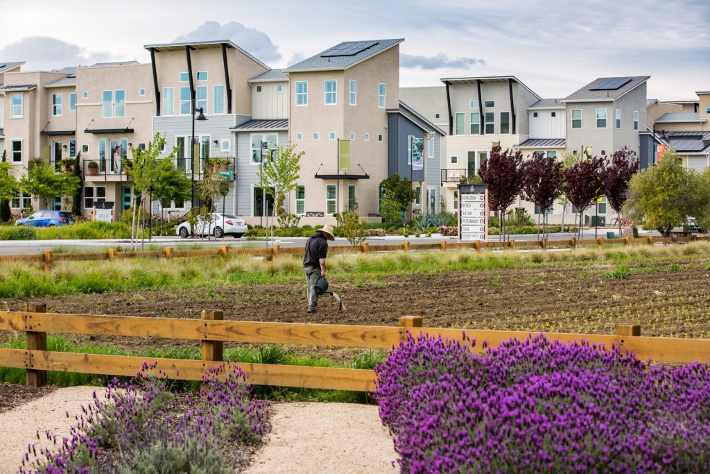
The solution? The Cannery, a 100-acre agrihood where housing, farmland, and community space coexist. Developed in partnership with The New Home Company and SWA Group, The Cannery became a model for integrating agriculture and residential development.
The Cannery: Design and Zoning Innovations
The Cannery is not just a neighborhood with a garden—it’s a fully integrated agrihood, where agriculture is central to the community’s design and economy. Here’s how it works:
1. Zoning for Agriculture + Housing
- Old Rule: Davis’s zoning traditionally separated housing and farmland, making it difficult to develop residential projects that included working farms.
- New Rule: The city created a special “Agrihood Overlay Zone” for The Cannery, requiring:
- At least 25% of the site (25 acres) to remain in active agricultural use, protected by a conservation easement.
- Farm infrastructure (e.g., irrigation, storage, farm stands) to be permanently maintained.
- Residential density bonuses for developers who included affordable housing and sustainable design (e.g., solar panels, drought-resistant landscaping).
2. Farm-Centric Design
- The Farm: A certified organic farm (operated by the Center for Land-Based Learning) grows vegetables, fruits, and flowers for residents and the broader community.
- CSA (Community Supported Agriculture) Program: Residents can subscribe to weekly farm boxes.
- Farm Stand: Open to the public, selling produce, honey, and value-added products (e.g., jams, pickles).
- Educational Programs: Workshops on sustainable farming, cooking, and composting.
- Housing: 547 homes (single-family, townhomes, and apartments), including 15% affordable units.
- Public Spaces:
- Walking/biking trails connecting homes to the farm and downtown Davis.
- Community barn for events, classes, and farm-to-table dinners.
- Orchard and vineyard areas where residents can pick fruit.
3. Sustainability Features
- Solar Panels: All homes are solar-ready, and the farm uses renewable energy for irrigation and storage.
- Water Conservation: Drip irrigation and greywater systems reduce water use by 40% compared to traditional developments.
- Walkability: The Cannery is designed so that all residents live within a 5-minute walk of the farm and trails.
Outcomes: Did It Work?
The Cannery’s impacts are measurable and ongoing. Here’s what changed by 2025:
| Metric | Pre-Cannery (2015) | Post-Cannery (2025) | Source |
|---|---|---|---|
| Agrihood Housing Units | n/a | 547 (15% of Davis’s new housing) | City of Davis Housing Report (2025) |
| Farm Profitability | Struggling small farms | 30% increase in revenue (via CSA, farm stand, events) | Center for Land-Based Learning (2024) |
| Local Food Access | Limited | 80% of residents participate in CSA or buy from farm stand | Cannery Resident Survey (2024) |
| Affordable Housing Units | 8% of new developments | 15% of Cannery units (82 homes) | Davis Affordable Housing Report (2025) |
| Walkability Score | 45 (car-dependent) | 78 (very walkable) | Walk Score (2025) |
| Water Use Reduction | Baseline | 40% lower than traditional developments | Davis Sustainability Report (2024) |
| Replication | None | 12+ agrihoods inspired by The Cannery (CO, OR, NC) | Agritecture (2024) |
Economic Impact
- Farm Revenue: The Cannery’s farm tripled its profits within 5 years by selling directly to residents and the public. CSA memberships grew from 50 to 300 households, and the farm stand now generates $250,000 annually (Center for Land-Based Learning, 2024).
- Property Values: Homes in The Cannery appreciated by 18% in 5 years, compared to 12% citywide (Zillow, 2025). Buyers cited the farm amenities and walkability as key selling points.
- Local Business Growth: The farm stand and community events drew visitors from across Yolo County, boosting sales for nearby restaurants and shops by 15% (Davis Chamber of Commerce, 2024).
Social and Environmental Impact
- Community Cohesion: 90% of Cannery residents reported feeling a stronger sense of community than in previous neighborhoods, citing the farm and shared spaces (University of California, Davis, 2023).
- Food Security: 60% of residents grow some of their own food in community garden plots or through the CSA.
- Carbon Footprint: The Cannery’s walkability and solar energy reduced household carbon emissions by 25% compared to Davis’s average (Davis Climate Action Plan, 2024).
Lessons Learned: What Worked (and What Didn’t)
Successes
- Farm + Housing Synergy
- Lesson: The farm isn’t just a marketing gimmick—it’s a profit center that supports the development’s financial viability. The direct-to-consumer model (CSA, farm stand) created a steady revenue stream for the farm and lowered grocery costs for residents.
- Quote: “The Cannery proves that farms and housing can support each other economically. The farm attracts buyers, and the residents provide a reliable market for the farm’s products.” — Craig McNamara, Center for Land-Based Learning
- Zoning as a Tool for Integration
- Lesson: Davis’s Agrihood Overlay Zone was critical. It required agricultural use while allowing flexible housing types, ensuring the farm wouldn’t be an afterthought.
- Example: The zoning prohibited future rezoning of the farmland, protecting it from development pressure.
- Affordability and Diversity
- Lesson: Including 15% affordable units ensured the Cannery wasn’t just for wealthy buyers. Diversity strengthened the community—teachers, farmers, and retirees live alongside tech workers and students.
- Example: The affordable units are clustered near the farm, giving lower-income residents equal access to amenities.
- Design for Walkability and Connection
- Lesson: The Cannery’s trails, barn, and farm stand are central to daily life. Residents walk more, drive less, and interact often—unlike traditional subdivisions.
- Example: The community barn hosts weekly potlucks, farming workshops, and kids’ camps, fostering social ties.
Challenges and Solutions
| Challenge | Solution |
|---|---|
| Developer Skepticism | The city offered density bonuses (extra units) for including the farm and affordable housing. The New Home Company saw higher sales prices due to the farm’s appeal. |
| Farm Viability Concerns | Partnered with Center for Land-Based Learning, a nonprofit with farming expertise, to manage the farm professionally. |
| Water Use Regulations | Used drip irrigation, greywater recycling, and drought-resistant crops to comply with California’s strict water laws. |
| Affordability Pressures | Secured state housing grants and low-income housing tax credits to fund affordable units. |
| Resident Engagement | Hosted monthly farm workdays and cooking classes to build community and educate residents about agriculture. |
Expert Opinions and Analysis
Why The Cannery Works
- It’s More Than a Development—It’s a Food System
- The Cannery integrates housing, agriculture, and community in a way that supports all three. The farm isn’t just decorative—it’s a functional part of the neighborhood’s economy and culture.
- Quote: “Most developments treat open space as an amenity. The Cannery treats agriculture as infrastructure—something that feeds the community in every sense.” — Henry Gordon-Smith, Agritecture
- Zoning Made It Possible
- Davis’s Agrihood Overlay Zone was innovative but replicable. It protected the farmland legally while allowing flexible housing designs.
- Example: The zoning required the farm to stay in production—not just as open space, but as a working, profitable enterprise.
- It’s a Model for Climate Resilience
- The Cannery’s walkability, solar energy, and local food production align with climate goals. Residents drive less, waste less food, and use fewer resources than in traditional suburbs.
- Quote: “This is what climate-adaptive development looks like: compact, food-secure, and community-driven.” — Michael Boswell, UC Davis Professor of City Planning
How Other Communities Can Replicate The Cannery
Step 1: Assess Your Farmland and Housing Needs
- Ask:
- Where is underutilized or at-risk farmland near your town?
- What housing demands exist (e.g., affordable units, senior housing, starter homes)?
- Are there local farmers or nonprofits who could partner on an agrihood?
- Tools:
- USDA’s Farmland Information Center (farmlandinfo.org) to map farmland.
- Local housing needs assessments (check with your city or county planning department).
Step 2: Create an Agrihood Zoning Overlay
- Action: Draft a special zoning district that:
- Requires a minimum percentage of land (e.g., 20–30%) to remain in active agricultural use.
- Allows mixed housing types (single-family, townhomes, apartments) to support diversity.
- Incentivizes affordability (e.g., density bonuses for affordable units).
- Example Language: “In the Agrihood Overlay District, at least 25% of the total site area must be dedicated to active agricultural use, managed by a qualified farm operator. Residential and commercial uses are permitted, provided they support the agricultural component.”
Step 3: Partner with Farmers and Nonprofits
- Action: Work with local farms, land trusts, or agricultural nonprofits to:
- Manage the farm (e.g., CSA programs, farm stands).
- Provide education (e.g., farming workshops, school programs).
- Example Partners:
- Land Trusts (e.g., American Farmland Trust) can hold conservation easements.
- Agricultural Nonprofits (e.g., Center for Land-Based Learning) can operate the farm and train new farmers.
Step 4: Design for Walkability and Community
- Action: Prioritize pedestrian-friendly design:
- Trails connecting homes to the farm and downtown.
- Community gathering spaces (e.g., barns, orchards, plazas).
- Mixed-use buildings (e.g., farm stand + café + housing).
- Example: The Cannery’s central barn and trails are its social heart—design your agrihood’s gathering spaces first.
Step 5: Pilot and Iterate
- Action: Start with a smaller agrihood project (e.g., 10–20 acres) to test the model before scaling up.
- Monitor:
- Farm profitability (CSA members, farm stand sales).
- Housing demand (sales prices, occupancy rates).
- Community engagement (event attendance, resident surveys).
Key Takeaways for Planners and Communities
1. Agrihoods Are a Tool for Rural and Urban Communities
- Not Just for Farm Towns: While Davis is agricultural, agrihoods work in suburban and exurban areas too (e.g., Colorado’s Agraria, North Carolina’s Serenbe).
- In fact, there tends to be more development pressure in urbanizing areas, supporting the economics to make agrihoods a viable alterhantive to sprawl.
- Adapt to Your Context: No farmland? Partner with community gardens, orchards, or urban farms.
2. Zoning Is the Foundation
- Protect the Farmland Legally: Use conservation easements and agrihood overlays to ensure the land stays in production.
- Allow Flexibility: Let the farm evolve (e.g., from vegetables to agri-tourism) as markets change.
3. The Farm Must Be Viable
- Business Plan First: Treat the farm as a business, not just an amenity. Partner with experienced farmers or nonprofits to manage it.
- Diversify Revenue Streams: CSAs, farm stands, events, and agri-tourism (e.g., weddings, workshops) can support profitability.
4. Affordability and Equity Matter
- Include Affordable Housing: Agrihoods risk becoming luxury developments—require 10–20% affordable units to keep them inclusive.
- Support Local Farmers: Offer low-cost leases or grants to help farmers start or expand operations.
5. Community Buy-In Is Critical
- Engage Early and Often: Host farm tours, design workshops, and potlucks to build excitement.
- Show the Benefits: Highlight lower grocery bills, walkability, and social connections—not just “pretty farm views.”
Conclusions and Advice
Why The Cannery Is a National Model
- It Proves Farmland and Housing Can Coexist: The Cannery didn’t sacrifice farmland for growth—it integrated them, creating a more resilient community.
- It’s Economically Viable: The farm pays for itself through direct sales, events, and grants, while the housing supports local businesses.
- It’s Replicable: Communities in Colorado, Oregon, and North Carolina have already adapted the model, proving it works in diverse climates and markets.
Opinions: What Makes This Model Special
- It’s Not Just Housing with a Garden: The Cannery is a fully integrated food system. The farm is central to the neighborhood’s identity and economy—not an afterthought.
- Zoning Made It Possible: Davis’s Agrihood Overlay Zone was innovative but simple. Other towns can adapt this tool without reinventing the wheel.
- It’s a Climate Solution: By reducing car dependency, supporting local food, and using renewable energy, The Cannery aligns with global sustainability goals.
Advice for Planners and Developers
- Start Small: Pilot an agrihood on 5–10 acres before scaling up. Monitor farm profitability and resident satisfaction.
- Partner with Experts: Work with land trusts, farming nonprofits, or agricultural extensions to manage the farm professionally.
- Design for Community: The farm and gathering spaces should be central and accessible—not tucked away.
- Use Zoning as a Tool: Create an Agrihood Overlay District to protect farmland and allow flexible housing.
- Make It Affordable: Include affordable units and support for farmers to ensure the agrihood serves all residents, not just the wealthy.
Supported by:
- SWA Group: The Cannery Project Overview
- Agritecture: The Challenges of a California Agrihood
- ATTRA/NCAT: Agrihoods – Development-Supported Agriculture
- Agriburbia—Agriculture for People and the Planet (Quint and Jennifer Redmond, classmates of mine from CU-Denver)
Final Thought: Agrihoods as the Future of Rural-Urban Living
The Cannery shows that agrihoods aren’t just a trend—they’re a practical solution for communities facing housing shortages, farmland loss, and climate challenges. By integrating agriculture into residential design, towns can:
- Preserve farmland while accommodating growth.
- Support local food systems and reduce carbon footprints.
- Create vibrant, walkable neighborhoods where people know their farmers and neighbors.
For planners and local leaders:
Don’t wait until your farmland is paved over. Start now: Identify a site, partner with a farmer, and rewrite one zoning rule to allow an agrihood. The Cannery proves that farmland and housing aren’t opposites—they’re partners in building a stronger community.
Planner’s Tip:
Don’t think of farmland and housing as opposites. Use zoning to frame them as complements—each supporting the long-term value of the other.

Five Principles for Rural Zoning That Works
Rural zoning doesn’t have to be complicated or contentious. When done right, it protects what residents love while enabling sensible growth. Here’s how to make zoning work for your small town or rural community, with real-world examples and actionable steps for each principle.
1. Write Codes People Can Understand
Why It Matters: Zoning codes written in legal jargon alienate residents and discourage participation. Clear, simple language—paired with visuals—helps everyone understand the rules, ask questions, and contribute meaningfully.
How to Do It:
- Use Plain Language:
- List different land uses in a Matrix for easy cross-reference, including what types of review are required in different zoning districts
- Present setbacks and dimensional standards in tables for easy reference and comparison
- Avoid acronyms (e.g., say “farmland protection zone” instead of “FPZ”).
- Consider avoiding formal codification services, which can be difficult for casual users of zoning regulations, if your municipal attorney will let you.
- Add Diagrams and Maps:
- Include simple sketches of allowed building types, setbacks, and lot layouts.
- Use before/after visuals to show how zoning changes could reshape a street or neighborhood.
- Avoid formal codification services if they will not allow you to include graphics.
- Example: A one-page infographic showing where tiny homes, farms, or home businesses are allowed.
- Create a “Zoning 101” Guide:
- Publish a short, illustrated brochure or website section explaining key terms (e.g., “setback,” “mixed-use,” “overlay district”).
- Host a “Zoning Coffee Hour” where residents can ask questions in a relaxed setting.
Real-World Example:
Port Townsend, Washington, rewrote its zoning code in plain language and added comic-style illustrations to explain rules. Plus videos! The result? Public engagement expanded, and the code passed with broad support.
2. Plan With the Community
Why It Matters: Zoning imposed from above often fails. Co-creating the rules with residents ensures they reflect local values—whether that’s protecting farmland, reviving Main Street, or adding sidewalks for kids.
How to Do It:
- Host a Community Charrette:
- Gather residents, farmers, and business owners for a hands-on workshop to map out priorities. Use sticky notes, markers, and large maps to visualize ideas.
- Ask: “What places in town need protecting? Where should growth happen?”
- Use Digital Tools:
- Platforms like Place Score or CommunityViz (one of my personal favorites) let residents pinpoint priorities (e.g., “We need a grocery store here” or “Save this view”).
- Example: Parkes, Australia, used a digital liveability survey to shape its zoning strategy, leading to a 30% increase in park usage.
- Focus on “What Matters”:
- Common rural priorities:
- Farmland buffers (e.g., “No development within 100 feet of a farm”).
- Viewshed protection (e.g., limits on building heights near scenic areas).
- Walkable Main Streets (e.g., mixed-use zoning to keep shops and homes close).
- Common rural priorities:
Real-World Example:
Middlebury, Vermont, held weekend charrettes to identify issues, create a vision, and develop a master plan for their downtown. These events were public, community-focused design sessions that brough people together to create plans for the town’s future.
3. Zone for What You Want
Why It Matters: Traditional zoning focuses on what’s prohibited. Smart rural zoning actively permits the things communities do want: affordable housing, local businesses, renewable energy, or farm preservation.
How to Do It:
- Permit by Right (Not by Exception):
- If your town wants tiny homes, farm stands, or solar arrays, write the code so these are allowed by right in certain zones—no special hearings needed.
- Example: “Accessory dwelling units (ADUs) are allowed on all lots over 1 acre in the Rural Residential zone.”
- Create “Yes” Zones:
- Designate areas where specific goals are prioritized:
- “Main Street Revival Zone”: Mixed-use buildings, minimal parking requirements, façade grants for historic storefronts.
- “Farmland Forever Zone”: Cluster housing only; 75% of land must stay in agriculture.
- “Renewable Energy Zone”: Streamlined approval for wind or solar projects.
- Designate areas where specific goals are prioritized:
- Incentivize Good Development:
- Offer fast-track reviews for projects which align with community goals expressed in the Comprehensive Plan (e.g., affordable housing, downtown revitalization).
Real-World Example:
Business owners in Burwell, Nebraska, asked the City to allow shipping containers to be used as storage units, instead of storing goods outdoors. This also would allow existing businesses to expand downtown instead of moving to the outskirts. After discussing pros and cons, the Planning Commission recommended a process to approve Portable Onsite Storage which the City Council adopted.
4. Protect What Makes You Unique
Why It Matters: Rural communities lose their identity when zoning ignores cultural landmarks, historic buildings, or natural landscapes. Overlay districts and design guidelines can safeguard these assets.
How to Do It:
- Use Overlay Districts:
- Apply extra rules to special areas:
- Historic District Overlay: Limits changes to building façades or signs.
- Scenic Corridor Overlay: Restricts billboards or tall buildings along a river or highway.
- Agricultural Overlay: Requires buffers (e.g., tree lines) between farms and new homes.
- Apply extra rules to special areas:
- Write Design Guidelines (Not Just Rules):
- Instead of saying “No vinyl siding,” say: “Buildings should use materials that reflect our town’s historic character, like wood, brick, or stone.”
- Include photos of “good fits” vs. “poor fits” for new construction.
- Protect Natural and Cultural Assets:
- Zone to preserve viewsheds, wetlands, or heritage sites.
- Example: Sedona, Arizona uses a Scenic Corridor Overlay to protect its famous red rock views.
Real-World Example:
Woodstock, Vermont, created a Historic District Overlay (Design Review District) to maintain its New England charm. The result? Tourism revenue increased and property values rose without displacing locals.
5. Make Room for Experimentation
Why It Matters: Permanent zoning changes can feel risky. Pilot projects—like pop-up parks, tiny home villages, or outdoor markets—let communities test ideas before committing.
How to Do It:
- Temporary Use Permits:
- Allow short-term projects (e.g., a weekend market, a tiny home village for seasonal workers) to test demand and impact.
- Example: “Food trucks can operate in the town square on Fridays for 6 months—then we’ll review.”
- Demonstration Projects:
- Partner with a local nonprofit or developer to pilot a new model:
- A tiny home community for farmworkers.
- A pop-up bike lane to gauge support for permanent infrastructure.
- Partner with a local nonprofit or developer to pilot a new model:
- Adaptive Reuse:
- Encourage creative reuse of empty buildings (e.g., a closed school becomes a community center with housing upstairs).
- Offer grants or tax breaks for adaptive reuse projects.
Real-World Example:
During the pandemic, Crested Butte, Colorado, like many other communities, piloted an outdoor dining “parklet” program for outdoor restaurant seating in rights-of-way. The pilot was reviewed and improved, and continues to be a popular option in the small mountain town.
Putting It All Together: A Checklist for Rural Zoning Success
| Principle | Action Steps | Tools/Resources |
|---|---|---|
| Write Codes People Can Understand | Use plain language; add diagrams; create a “Zoning 101” guide. | Plain Language Guides, Canva for infographics |
| Plan With the Community | Host charrettes; use digital tools; ask “What matters?” | Place Score, CommunityViz, Miro |
| Zone for What You Want | Permit desired uses by right; create “Yes” zones; incentivize good development. | Model zoning codes from APA |
| Protect What Makes You Unique | Use overlay districts; write design guidelines; safeguard natural/cultural assets. | National Register of Historic Places |
| Make Room for Experimentation | Pilot temporary uses; test adaptive reuse; review and adapt. | Temporary Use Permit Templates |

Key Takeaway
Rural zoning works best when it’s clear, collaborative, and flexible. By focusing on what communities love (not just what they fear), planners can create rules that preserve character, enable opportunity, and adapt over time.
Start small: Pick one principle—like rewriting a section of your zoning code in plain language or hosting a charrette—and build from there.
Action Steps for Planners
- Audit Your Zoning Code: Does it reflect current needs and values? Invite peer review or host a zoning clinic.
- Pick One Pilot: Start with a farm edge, a downtown block, or a school site. Test new approaches on a small scale.
- Learn from Peers: Reach out to planners in Vermont, Missoula, and Davis. What worked? What didn’t?
- Bring Real Voices to the Table: Farmers, renters, youth, and small business owners should shape how zoning is implemented.
The Bottom Line
Zoning in small towns isn’t about controlling change. It’s about shaping it. The best land use codes are rooted in community values, not abstract ideals. They protect what’s cherished—farmland, place identity, and social fabric—while allowing for smart, grounded growth.
What’s one zoning change your community could make this year to better reflect its people and place?

Read More & Take Action
Books
1. The Smart Growth Manual
Authors: Andres Duany, Jeff Speck, and Mike Lydon Publication Year: 2010 (with timeless principles still relevant in 2025) Focus: A practical guide to implementing “smart growth” principles—such as compact development, mixed-use zoning, and preserving open spaces—in both urban and rural communities. It includes case studies, illustrations, and step-by-step guidelines for local planners.
Why It’s Relevant:
- The original good town planning book
- Tips for engaging communities in planning processes.
- Examples of successful projects in the U.S.
2. Rural by Design: Planning for Town and Country
Author: Randall Arendt Publication Year: 1994 (2nd edition, 2019) Focus: A classic resource for rural planners, offering strategies to balance growth, conservation, and community character. Arendt emphasizes designing with the land, protecting farmland, and creating walkable rural villages.
Why It’s Relevant:
- Cluster development and conservation subdivisions as tools for rural zoning.
- Visual examples of how to integrate housing with open space.
- Community engagement techniques for rural planning.
- Where to Find: This is a very expensive book, even for a used edition. Ask at your library!
3. “Zoning for Small Towns: A Practical Guide”
Author: American Planning Association (APA) Publication Year: 2020 (part of the APA’s “Planning Advisory Service” series) Focus: A hands-on guide specifically for small towns, covering simplified zoning codes, mixed-use districts, and community engagement. It includes templates, checklists, and examples of successful rural zoning ordinances.
Why It’s Relevant:
- Step-by-step instructions for updating zoning codes.
- Examples of rural zoning ordinances from across the U.S.
- Tips for avoiding bureaucratic overreach while protecting local character. Where to Find: APA Planners Press
4. The Option of Urbanism: Investing in a New American Dream
Author: Christopher B. Leinberger Publication Year: 2008 (with insights still applicable to rural and small-town planning) Focus: While primarily urban-focused, this book explores walkable communities, mixed-use development, and the economic benefits of smart growth—principles that can be adapted for rural towns.
Why It’s Relevant:
- Market-driven arguments for mixed-use zoning and compact development.
- Case studies of small towns that have revitalized their downtowns.
- Ideas for attracting investment while preserving rural character.
5. Local Planning: Contemporary Principles and Practice
Authors: Edited by Gary Hack, Eugenie L. Birch, Paul H. Sedway, Mitchell J. Silver Publication Year: 2008 Focus: This successor to the “Green Bible” this is a comprehensive textbook on local planning, including chapters on rural zoning, land-use regulation, and community participation. It’s ideal for both practitioners and students.
Why It’s Relevant:
- Detailed explanations of zoning tools like overlay districts and form-based codes.
- Examples of rural and small-town planning from the U.S. and Canada.
- Ethical considerations in local planning decisions.
6. The Citizen’s Guide to Planning
Authors: Christopher Duerksen, Gregory Dale, and Donald Elliot Publication Year: 2019 Focus: A user-friendly guide for citizens and local officials, explaining how planning and zoning work—and how communities can shape their own futures.
Why It’s Relevant:
- Plain-language explanations of zoning, comprehensive plans, and land-use regulations.
- Tips for organizing community meetings and advocating for better planning.
- Case studies of small towns that have successfully updated their zoning.
- The authors are all really cool guys.
7. An Even Better Way to Zone: Achieving More Affordable, Equitable, and Sustainable Communities
Author: Donald Elliot Publication Year: 2025 Focus: Elliott explains how outdated assumptions about development and unnecessary barriers in our current zoning regulations have contributed to development patterns that are not sustainable, affordable, or equitable to historically disadvantaged populations. It identifies what types of changes to zoning rules, procedures, and maps could improve outcomes in each of those areas. Importantly, it also helps the reader think through what to do when zoning changes that would improve outcomes for one of those challenges would undermine success in the others.
Why It’s Relevant:
- Forthcoming December 2, 2025; pre-order yours now.
- The author is a really cool guy.
Resources
- USDA Rural Development: Grants and Loans for Rural Housing and Infrastructure
- Center for Zoning Solutions / formerly the Form-Based Codes Institute: Design-Based Zoning for Small Towns
- CivicWell: Rural Smart Growth Strategies
Action Steps
- Audit Your Zoning Code: Is it helping or hindering your community’s goals? Invite a planning expert to review it.
- Host a Community Visioning Session: Use sticky notes, maps, and photos to gather ideas for how land should be used.
- Start Small: Pick one project—a downtown block, a farm, a vacant lot—and use it to pilot a new zoning approach.
- Learn from Others: Reach out to towns with successful models (like Missoula or Davis) and ask for their lessons learned.
Looking for more?
- The New Rural Playbook: Planning Trends That Matter
- Planning with Purpose: Emerging Trends in Rural and Small Town Planning
- Thriving Together: Proven Strategies for Sustainable Rural Economies in 2025
- Wired for Change: Rural America and the Energy Economy of Tomorrow
The Best Books for Rural Development and Planning in 2025 and check out the Small Town & Rural Community guides on our Resources page.
(As an Amazon Associate, we may earn commissions from qualifying purchases. Check your local library or bookshop, too.)